RiverReports preview · current series loading
Recent flow
RiverReports gauge
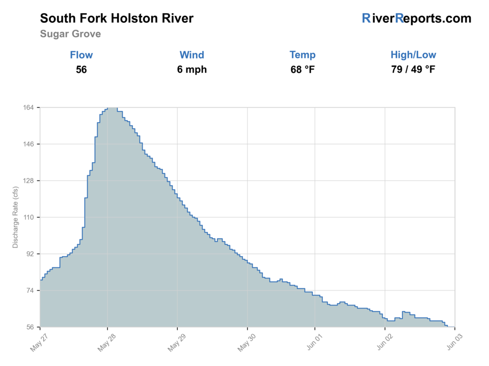
Showing the available RiverReports chart while the current structured flow series loads. Check the chart on RiverReports Opens in a new tab.
If you go: Wading. Wading is the most sensitive plan today. Use protected edges only, avoid crossings, and downgrade quickly if clarity or current feels wrong.
Rating updatedRiver local time:
Wade: Wading is the most sensitive plan today. Use protected edges only, avoid crossings, and downgrade quickly if clarity or current feels wrong.
NWS air forecast near
This is an air forecast, not a river-temperature reading. Check the water with a stream thermometer before fishing in hot weather.
RiverReports gauge
Showing the available RiverReports chart while the current structured flow series loads. Check the chart on RiverReports Opens in a new tab.
Clear
The National Weather Service forecast is temporarily unavailable.
RiverReports gauge: South Fork Holston River at Sugar Grove
Seasonal starting points, not a live hatch report. Match what you see on the water.
Each fly name opens its matching Fly Box guide.
The strongest Virginia South Fork Holston plan is cool, stable, and section-by-section. If you want the Tennessee dam tailwater, use that separate report and generation sources instead.
Use stealth, small nymphs, and light tippet in better oxygenated water.
Dry-droppers and short indicator rigs work well through pockets.
Streamers and heavier nymphs can work from safe banks and edges.
Check temperature and move or stop when trout handling becomes risky.
These scores compare the risks of wading, bank fishing, and floating.
Wading is the most sensitive plan today. Use protected edges only, avoid crossings, and downgrade quickly if clarity or current feels wrong.
This report does not recommend bank fishing on this reach.
This report does not recommend floating this reach.
Is South Fork Holston River worth the trip today? Check flow, weather, hatches, access, and rules for Virginia before you go.
The South Fork Holston in Virginia is a special fishing rule and stocked-trout drainage around Sugar Grove and Buller. Do not apply South Holston Dam tailwater guidance from Tennessee to this page.
Wade: Wading is the most sensitive plan today. Use protected edges only, avoid crossings, and downgrade quickly if clarity or current feels wrong.
USGS shows 53 cfs. The flow has been stable over about 6 hours. USGS marks this reading provisional and may revise it. USGS records for this date (1921-2026, 96 readings) show a median near 35 cfs and the upper quartile near 52 cfs; today's flow is high for the date. Fishable water may exist, but do not rate it highly without a safe access, clarity, and wading or boat plan.
Fall: Cooler water, lower pressure, and streamer opportunities improve.
The current NWS air forecast is about 49F, and the next 24-hour high reaches about 67F. Clear.
No active NWS alert was returned for this forecast point.
Use RiverReports and USGS 03471500 near Chilhowie as the main live trend. Stable medium water supports dry-droppers and pocket-water nymphing. High, stained, or warm water should shorten the plan or move it.
Skip or change the plan when section-by-section rules are unclear, the river is rising after storms, water is warm enough to stress trout, roadside access is questionable, or the plan relies on Tennessee tailwater generation assumptions.
Start with Virginia DWR trout rules and the Holston River South Fork waterbody page, then match Sugar Grove weather and near-Chilhowie flow to one legal upper-river reach.
If the Virginia South Fork Holston is high, warm, crowded, or rule-complicated, compare the Tennessee South Holston River, Lower Jackson River, or Upper James River before forcing the same plan.
Use these places as starting points. Open the access link below and check posted signs before you park or enter.
Check Virginia DWR trout rules and South Fork Holston waterbody information for current section-by-section rules.
Core upper-river orientation and RiverReports match.
Important DWR special fishing rule and hatchery-area planning.
Different downstream flow and species expectations.
Official agencies and primary river operators come first. Secondary tools are labeled so you know what carries the most weight.
Check what is allowed, where the rule applies, and whether the river is open.
Check the latest river reading and forecast before you leave.
Check public entry points, land rules, and seasonal access changes.
Check what is allowed, where the rule applies, and whether the river is open.
Open the current rules and check the river section, season, and special limits.
Open the current rules and check the river section, season, and special limits.
Check the latest river reading and forecast before you leave.
Open this page and check the latest safety advice before your trip.
Open this river reading to check the latest level, flow, and update time.
Open this river reading to check the latest level, flow, and update time.
Check public entry points, land rules, and seasonal access changes.
Open the land or access page, then check signs before you park or enter.
What was checked: This report is maintained from current regulation, access, flow, weather, and public planning sources so anglers can make better trip decisions than a raw gauge or generic overview would allow.
Live measurements and forecasts keep their provider timestamps. Rules, access, and trip guidance use the source-review date shown here. BlueStreamFly planning advice is editorial interpretation, not an agency notice.
First-hand experience: BlueStreamFly does not claim a first-hand visit or local field test for this report unless a real contributor is explicitly named and linked.
Check Virginia DWR reach rules, Sugar Grove/Riverside flow, stockings, water temperature, and access.
Start around Sugar Grove or Buller after confirming the exact rule section you plan to fish.
Yes in safe, stable flows, but warm water and special fishing rule reach boundaries matter.
Bring the seasonal fly box, then adjust size, weight, and color to the water level, clarity, temperature, and pressure you find.
















