Fly fishing river flowing through a wooded mountain valley

Fly fishing report · Rockies

Flat Creek

A Jackson-area Flat Creek report built around the below-Cache-Creek gauge, National Elk Refuge fishing seasons, and realistic low-gradient trout planning near town.

Check flow & weather
Today's fishing decisionMost live data available
Use caution

Flat Creek is a cautious call right now.

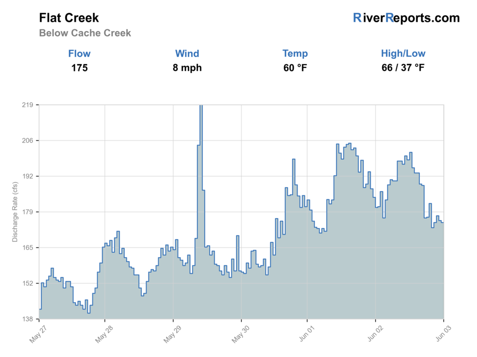
Current USGS flow is 136 cfs and has been stable for about 6 hours. Today's flow is high for this date; the upper end of the normal range is near 135 cfs. Fishable water may exist, but do not rate it highly without a safe access, clarity, and wading or boat plan.

Best supported approachFloat
Watch nextFlow: Current USGS flow is 136 cfs and has been stable for about 6 hours. Today's flow is high for this date; the upper end of the normal range is near 135 cfs.
Updated Aug 5, 1:45 PM UTCUsually refreshes about every 45 minutes
Best supported approachFloat

Compare wading, bank fishing, and floating before choosing how you will fish.

Wade49/100

Wading is the most sensitive plan today. Use protected edges only, avoid crossings, and downgrade quickly if clarity or current feels wrong.

Bank / edge61/100

Bank and edge fishing is the safer default when water is high, pushy, or not fully verified.

Float · Best fit73/100

A float can fit better than wading only if launches, shuttle, boat skill, wind, and local rules all check out.

Check before you drive

Current flow and weather.

Look at whether the river is rising or falling, then check wind, rain, and storms. These can change both safety and fishing.

Loading current flow and weather.

Before you rely on this report

How current is this report?

Conditions can change quickly. Check these dates before you decide to fish, and open the official source when safety or rules matter.

River conditions
Checked Aug 5, 2026, 9:45 AM

High confidence in the current score inputs.

Fishing guidance
Reviewed Jun 2, 2026

6 sources are listed below for you to open.

Public access
No reviewed map pin available

3 public access records are listed. Private spots are never shown.

Rules and closures
Official rule links checked

Source checked Jul 30, 2026

Plan your access

Know where you can enter.

These are public parking, launch, trail, or recreation areas—not secret fishing spots. We never show an angler's private pins, notes, or photos here.

0
Shown on map
3
No map pin
Location checkedDescription only
01

Roadside access

McBride Bridge corridor

No map pin

The key official reference point separating upper Flat Creek access on the refuge page.

Restrictions and seasonal notes

The refuge page says upper Flat Creek is open from May 1 through November 30 upstream from McBride Bridge to the national forest boundary.

Lower Flat Creek is open only from August 1 through October 31 between posted boundaries and is artificial-flies-only.

Official source Checked Jun 2, 2026
02

Area description

Posted lower Flat Creek boundaries

No map pin

The only responsible way to plan the late-summer lower reach.

Restrictions and seasonal notes

The refuge page says upper Flat Creek is open from May 1 through November 30 upstream from McBride Bridge to the national forest boundary.

Lower Flat Creek is open only from August 1 through October 31 between posted boundaries and is artificial-flies-only.

Official source Checked Jun 2, 2026
03

Area description

Jackson National Fish Hatchery area

No map pin

Useful orientation support when pairing a town day with refuge-managed water.

Restrictions and seasonal notes

The refuge page says upper Flat Creek is open from May 1 through November 30 upstream from McBride Bridge to the national forest boundary.

Lower Flat Creek is open only from August 1 through October 31 between posted boundaries and is artificial-flies-only.

Official source Checked Jun 2, 2026

How to fish it

Flat Creek is worth fishing when the season window, the posted reach, and the water temperature all line up, not when you assume every Jackson creek bend is open and cold.

This lower Flat Creek route is defined as much by refuge season dates and posted boundaries as by the water itself. Keep RiverReports open for trend context, confirm with USGS 13018350, and build the day around the exact National Elk Refuge window that matches your reach.

  • The refuge page says upper Flat Creek is open from May 1 through November 30 upstream from McBride Bridge to the Bridger-Teton National Forest boundary.
  • The same page says lower Flat Creek is open only from August 1 through October 31 between posted boundaries and is artificial-flies-only.
  • All other refuge waters are closed, which makes this a river where posted signs matter as much as fly choice.
  • Because this is low-gradient Jackson water, temperature and fish handling can decide the day before the flow chart does.
Why the score looks this way
FlowUse caution

USGS shows 136 cfs with a stable over about 6 hours trend. Today's flow is high for this date; the upper end of the normal range is near 135 cfs. Fishable water may exist, but do not rate it highly without a safe access, clarity, and wading or boat plan.

SeasonHelps score

Summer: Best on cooler mornings and only on sections currently open under refuge rules.

Water temperatureHelps score

USGS water temperature is about 59F, with no heat stop triggered.

Public alertsHelps score

No active NWS alert was returned for this forecast point.

Fishing usefulnessHelps score

Skip when the refuge season is closed, when temperatures are climbing, or when muddy runoff wipes out sightlines and structure.

Read the water

What changes the plan.

Flat Creek below Cache Creek is best as a deliberate late-summer or fall plan when the lower refuge section is open, or as a cooler-season upper-window option when the creek still has healthy trout temperatures. Skip it when the seasonal boundary is closed or when warm low water turns the creek into a poor trout decision.

01

Cool clear summer flow

Good only if the posted open reach is in season and the water stays trout-safe.

02

Late-summer low flow

Fish early, fish lightly, and leave if temperatures climb.

03

Autumn moderate flow

Often the best lower-section window because access lines up with cooler weather.

04

Muddy runoff

A pass for this low-gradient route because the creek loses clarity and structure fast.

Your trip plan

Know when to go—and when to skip it.

Best flows

Best on moderate clear flows with cool temperatures. Lower autumn windows often fish best because weather improves as access opens.

When to skip

Skip when the refuge season is closed, when temperatures are climbing, or when muddy runoff wipes out sightlines and structure.

Local plan

Confirm the exact open section first, fish early, and keep a Snake River backup ready if Flat Creek looks warm or crowded.

Backup water

Move to the Snake or a Yellowstone park day if Flat Creek is closed, warm, or too pressured to fish well.

Hatches & flies

Bring a flexible box.

TimingWhat to watchUseful flies

What to carry

Choose flies for the water you expect.

Use the condition that best matches your plan, then open a reviewed guide to identify and fish the pattern.

ApproachFlies to bringWhen it fits
01

Match the trip to the correct refuge section first, then match flies to the water.

02

Sight-fish or prospect with small accurate drifts instead of covering water blindly.

03

On warm days, fish early and stop early because temperature is the first serious risk here.

04

If the posted boundary is unclear, treat it as closed until you know otherwise.

Rules & closures

Check the official rules before you go.

Open the agency page to confirm the exact river section, species, season, tackle rules, limits, and emergency closures.

Official links checked
Rules for this river or sectionNo special rule found
We did not find a special rule for this river.

We checked the state source but did not find a clearly supported exception for this river. Check the official rules for the exact section you plan to fish.

Rules checkedJul 30, 2026
Report a correction ↗
Always follow the official rule

This summary helps with trip planning. The linked agency rule is the one you must follow.

Updates from anglers

What anglers are seeing.

Recent observations from general areas of Flat Creek. We review every update before it appears and never publish exact fishing spots, private access details, or photo locations.

Angler updates are not loading right now.

You can still use the river plan above. Check back later for recent observations from other anglers.

Where this report comes from

Open the sources we checked.

Fishing guidance checked: Jun 2, 2026

Site check: Jul 14, 2026. We regularly test report links, live scores, flow and weather data, and page loading. The content date changes only when the fishing guidance or its sources change.

Common questions

Before you leave.

When is the lower Flat Creek section below Cache Creek open?+

The National Elk Refuge says the lower Flat Creek section is open from August 1 through October 31 between posted boundaries, and it is artificial-flies-only.

What should I check before fishing Flat Creek near Jackson?+

Check the refuge fishing page, the posted boundary signs, USGS 13018350, water temperature, and Wyoming regulations before you rig up.

When should I skip Flat Creek?+

Skip it when your target section is out of season, when posted boundaries are unclear, or when warm low water makes trout handling questionable.