RiverReports preview · current series loading
Recent flow
RiverReports gauge
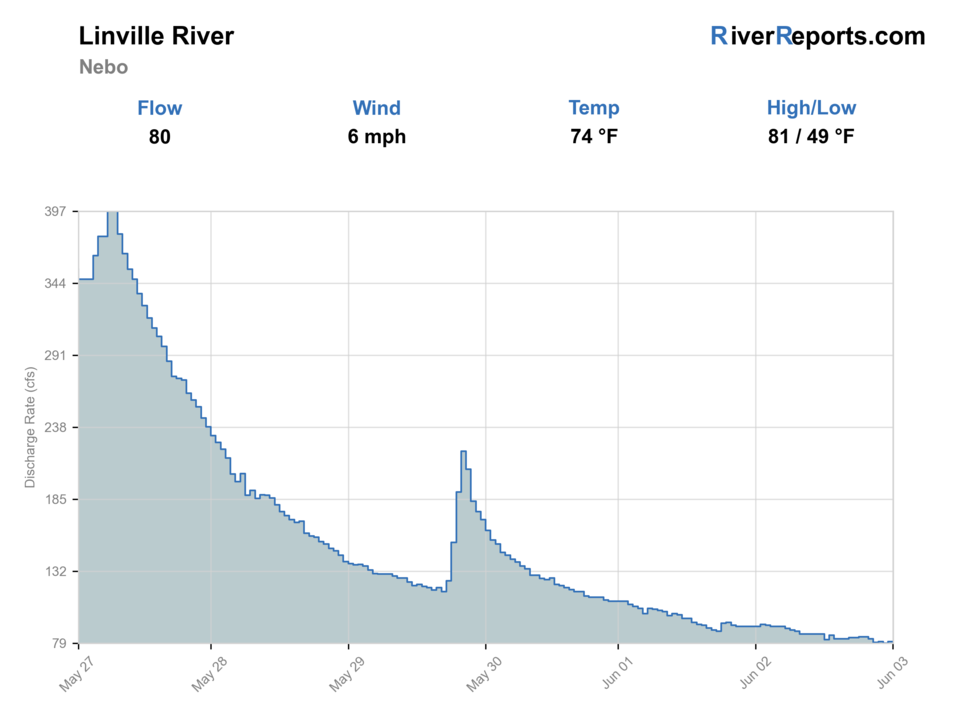
Showing the available RiverReports chart while the current structured flow series loads. Check the chart on RiverReports Opens in a new tab.
Generated artwork: BlueStreamFly · Regional illustration; not the exact location.
Best option: Floating. A float can fit better than wading only if launches, shuttle, boat skill, wind, and local rules all check out.
Check first: Water temperature is unconfirmed. Use a stream thermometer before fishing.
Rating updatedRiver local time:
USGS shows 634 cfs. The flow has been rising about 25% over about 6 hours. USGS marks this reading provisional and may revise it. USGS records for this date (1922-2025, 104 readings) show a median near 57 cfs and a high-water marker near 170 cfs; today's flow is above that high-water marker. Treat this as high-water fishing: wading, clarity, crossings, and boat control need a conservative check.
NWS air forecast near
This is an air forecast, not a river-temperature reading. Check the water with a stream thermometer before fishing in hot weather.
RiverReports gauge
Showing the available RiverReports chart while the current structured flow series loads. Check the chart on RiverReports Opens in a new tab.
Chance Rain Showers
The National Weather Service forecast is temporarily unavailable.
RiverReports gauge: Linville River near Nebo
Seasonal starting points, not a live hatch report. Match what you see on the water.
Also try foam dry-dropper
Each fly name opens its matching Fly Box guide.
Best fishing windows are stable, clear, and safe enough to approach without rushing. High water, thunderstorms, poor trail information, or limited daylight should push the plan toward easier nearby water.
Best for careful pocket-water nymphing and dry-dropper fishing.
Avoid wading and steep descents. The terrain raises the consequence of a bad decision.
Fish shaded pockets, long leaders, and quiet approaches.
Leave early or choose another river. Gorge escape routes take time.
These scores compare the risks of wading, bank fishing, and floating.
Wading is the most sensitive plan today. Use protected edges only, avoid crossings, and downgrade quickly if clarity or current feels wrong.
This report does not recommend bank fishing on this reach.
A float can fit better than wading only if launches, shuttle, boat skill, wind, and local rules all check out.
Is Linville River worth the trip today? Check flow, weather, hatches, access, and rules for North Carolina before you go.
The Linville River can be beautiful and productive, but the gorge makes access and safety the first decision. Check the gauge, Forest Service conditions, NCWRC rules, and weather before you decide whether to fish, scout from above, or pick an easier river.
USGS shows 634 cfs. The flow has been rising about 25% over about 6 hours. USGS marks this reading provisional and may revise it. USGS records for this date (1922-2025, 104 readings) show a median near 57 cfs and a high-water marker near 170 cfs; today's flow is above that high-water marker. Treat this as high-water fishing: wading, clarity, crossings, and boat control need a conservative check.
Float: A float can fit better than wading only if launches, shuttle, boat skill, wind, and local rules all check out.
Fall: Often the best mix of cooler weather, lower water, and better hiking conditions.
The current NWS air forecast is about 56F, and the next 24-hour high reaches about 64F. Chance Rain Showers.
No active NWS alert was returned for this forecast point.
Clear moderate flows that leave safe entries and enough pocket-water depth without making crossings dangerous.
Skip during high water, storms, poor trail conditions, late starts, or limited daylight.
Base near Linville Falls, Marion, Morganton, or Nebo. Check the gauge and Forest Service conditions before choosing access.
Catawba, Davidson, and Nantahala pages give safer alternatives when Linville is too high or the access window is poor.
Use these places as starting points. Open the access link below and check posted signs before you park or enter.
Check NCWRC rules and trout-water classifications before fishing. Forest Service access rules, closures, and wilderness restrictions also matter.
Check Forest Service conditions, closures, permits, and trail status before committing.
Useful for gorge orientation and road/trail planning, not automatic river access.
Use the gauge to judge whether the river is safe before driving into more difficult access.
Official agencies and primary river operators come first. Secondary tools are labeled so you know what carries the most weight.
Check what is allowed, where the rule applies, and whether the river is open.
Check the latest river reading and forecast before you leave.
Check public entry points, land rules, and seasonal access changes.
Use these links for stocking, safety, and other local details.
Check what is allowed, where the rule applies, and whether the river is open.
Open the current rules and check the river section, season, and special limits.
Check the latest river reading and forecast before you leave.
Open this page and check the latest safety advice before your trip.
Open this river reading to check the latest level, flow, and update time.
Open this river reading to check the latest level, flow, and update time.
Check public entry points, land rules, and seasonal access changes.
Open the land or access page, then check signs before you park or enter.
Open the land or access page, then check signs before you park or enter.
Use these links for stocking, safety, and other local details.
Open this page for more river information and check when it was last updated.
What was checked: This report starts with official regulation, access, flow, weather, and public-land sources, then adds practical planning guidance for fly anglers.
Live measurements and forecasts keep their provider timestamps. Rules, access, and trip guidance use the source-review date shown here. BlueStreamFly planning advice is editorial interpretation, not an agency notice.
First-hand experience: BlueStreamFly does not claim a first-hand visit or local field test for this report unless a real contributor is explicitly named and linked.
Use RiverReports for the quick chart and USGS 02138500 near Nebo for the official gauge reference.
No. Many routes are steep, primitive, and condition-dependent. Check Forest Service information before committing.
Choose another river during high water, storm threats, poor trail conditions, late starts, or when your group is not prepared for gorge travel.