RiverReports preview · current series loading
Recent flow
RiverReports gauge
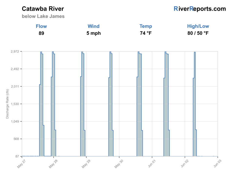
Showing the available RiverReports chart while the current structured flow series loads. Check the chart on RiverReports Opens in a new tab.
No single best way to fish. Wading, Bank fishing, and Floating have the same top score. Use current access, footing, weather, and local rules to choose.
Rating updatedRiver local time:
USGS shows 108 cfs. The flow has been stable over about 6 hours. USGS marks this reading provisional and may revise it. USGS records for this date (2010-2026, 16 readings) show a median near 523 cfs and the lower quartile near 325 cfs; today's flow is below normal for the date. This is below normal, so edge depth, temperature, and pressure matter.
NWS air forecast near
RiverReports gauge
Showing the available RiverReports chart while the current structured flow series loads. Check the chart on RiverReports Opens in a new tab.
Sunny
The National Weather Service forecast is temporarily unavailable.
RiverReports gauge: Catawba River below Lake James
Seasonal starting points, not a live hatch report. Match what you see on the water.
Each fly name opens its matching Fly Box guide.
The best fly-fishing window is stable water with enough clarity to read banks and riffles. Low warm water favors early starts and smallmouth or panfish tactics. Higher or changing water favors bank scouting, streamers near edges, or waiting for a safer level.
Best for cautious wading, nymphing seams, and bank-focused streamers.
Avoid mid-channel wading and keep the plan close to shore.
Fish early, check temperature, and shift to warmwater targets when trout stress is likely.
Use small streamers or larger nymphs tight to softer edges.
Wading, Bank fishing, and Floating have the same top score. Use current access, footing, weather, and local rules to choose.
Wading is in play only where your chosen access has clear footing, legal entry, and no forced crossings.
Bank and edge fishing remains a practical low-commitment option if access is legal and footing is safe.
A float is in play where this report supports boat access and wind, releases, and shuttle logistics are manageable.
Is Catawba River worth the trip today? Check flow, weather, hatches, access, and rules for North Carolina before you go.
The Catawba below Lake James can shift from comfortable edge water to a stronger tailwater-style river. Start with the live gauge, then choose whether the day is better for cautious wading, bank fishing, or a float-oriented smallmouth plan.
USGS shows 108 cfs. The flow has been stable over about 6 hours. USGS marks this reading provisional and may revise it. USGS records for this date (2010-2026, 16 readings) show a median near 523 cfs and the lower quartile near 325 cfs; today's flow is below normal for the date. This is below normal, so edge depth, temperature, and pressure matter.
Trout and salmonids need extra handling discipline in this temperature window; consider warmwater targets where that matches the river and rules.
USGS water temperature is about 68.9F. USGS marks the temperature data provisional and may revise it. Fish early and stop if handling stress is likely.
Wade: Wading is in play only where your chosen access has clear footing, legal entry, and no forced crossings.
Fall: Stable flows and cooling weather can improve streamer and nymph options.
Stable moderate flows that leave visible edges, safe entries, and enough cover for fish without pushing anglers into heavy current.
Skip wading during rising releases, muddy water, unclear access, or warm-water trout stress.
Base around Morganton, Marion, Bridgewater, or Lake James. Check the gauge first, then pick a trout or warmwater tactic.
Linville River, Davidson River, and New River pages give nearby alternatives when Catawba flows or temperatures are wrong.
Use these places as starting points. Open the access link below and check posted signs before you park or enter.
Check NCWRC rules and any Public Mountain Trout Waters classification before fishing. Rules can change by reach and season.
Use the gauge, legal parking, and posted access before entering the river.
Check current public access options rather than assuming roadside pullouts are legal.
Better suited to warmwater tactics when summer temperatures rise.
Official agencies and primary river operators come first. Secondary tools are labeled so you know what carries the most weight.
Check what is allowed, where the rule applies, and whether the river is open.
Check the latest river reading and forecast before you leave.
Check public entry points, land rules, and seasonal access changes.
Use these links for stocking, safety, and other local details.
Check what is allowed, where the rule applies, and whether the river is open.
Open the current rules and check the river section, season, and special limits.
Check the latest river reading and forecast before you leave.
Open this page and check the latest safety advice before your trip.
Open this river reading to check the latest level, flow, and update time.
Open this river reading to check the latest level, flow, and update time.
Check public entry points, land rules, and seasonal access changes.
Open the land or access page, then check signs before you park or enter.
Use these links for stocking, safety, and other local details.
Open this page for more river information and check when it was last updated.
What was checked: This report starts with official regulation, access, flow, weather, and public-land sources, then adds practical planning guidance for fly anglers.
Live measurements and forecasts keep their provider timestamps. Rules, access, and trip guidance use the source-review date shown here. BlueStreamFly planning advice is editorial interpretation, not an agency notice.
First-hand experience: BlueStreamFly does not claim a first-hand visit or local field test for this report unless a real contributor is explicitly named and linked.
Use RiverReports for the quick chart and USGS 02138520 below Lake James near Bridgewater for the official gauge reference.
It can be either depending on reach, season, and temperature. Check NCWRC rules and use a thermometer before handling trout in warm water.
Only when the gauge and release conditions are safe. If water is rising or strong, stay on the bank or choose another plan.