Wade · Best fit74/100
Wading is in play only where your chosen access has clear footing, legal entry, and no forced crossings.
Fly fishing report · Southeast
A Nantahala report for lower gorge flows, upper delayed-harvest context, release safety, public trout rules, access, hatches, and tactics.
Check flow & weatherCurrent USGS flow is 225 cfs. It has fallen about 67% over the past 6 hours. Today's flow is unusually low for this date and below the usual low-water marker near 231 cfs. Low water can make fish spooky, warm, pressured, or concentrated; check temperature and handling risk.
Compare wading, bank fishing, and floating before choosing how you will fish.
Wading is in play only where your chosen access has clear footing, legal entry, and no forced crossings.
Bank and edge fishing remains a practical low-commitment option if access is legal and footing is safe.
This report does not describe this as a primary mode. Verify legal access, depth, launches, and retreat options before planning around it.
Check before you drive
Look at whether the river is rising or falling, then check wind, rain, and storms. These can change both safety and fishing.
Before you rely on this report
Conditions can change quickly. Check these dates before you decide to fish, and open the official source when safety or rules matter.
High confidence in the current score inputs.
8 sources are listed below for you to open.
3 public access records are listed. Private spots are never shown.
Source checked Jul 30, 2026
Plan your access
These are public parking, launch, trail, or recreation areas—not secret fishing spots. We never show an angler's private pins, notes, or photos here.
Area description
Whiteoak Creek to hydropower discharge canal rule context.
Upper and lower Nantahala reaches are not interchangeable; check rules and flow for the exact water.
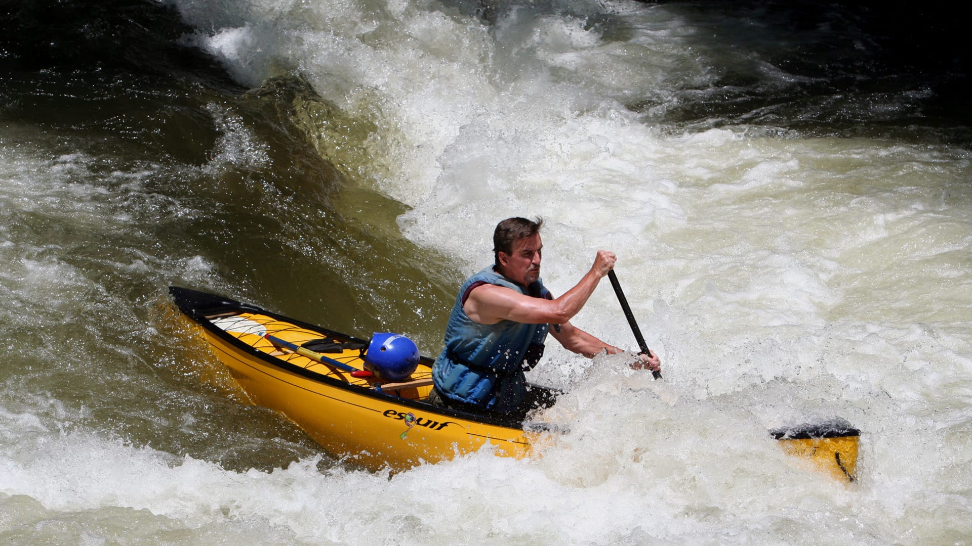
Raft traffic can make midday lower-gorge fly fishing less effective and less safe.
Area description
USFS and whitewater corridor planning with release awareness.
Upper and lower Nantahala reaches are not interchangeable; check rules and flow for the exact water.
Raft traffic can make midday lower-gorge fly fishing less effective and less safe.
Area description
Primary lower-river flow reference.
Upper and lower Nantahala reaches are not interchangeable; check rules and flow for the exact water.
Raft traffic can make midday lower-gorge fly fishing less effective and less safe.
How to fish it
The Nantahala changes character by reach. The upper river has delayed-harvest and forest-road trout planning, while the lower gorge is release-aware water with whitewater traffic.
USGS shows 225 cfs with a falling about 67% over about 6 hours trend. Today's flow is unusually low for this date and below the usual low-water marker near 231 cfs. Low water can make fish spooky, warm, pressured, or concentrated; check temperature and handling risk.
Summer: Early, shaded, or release-aware windows; watch heat and rafting pressure.
The NWS forecast is about 75F with Partly Cloudy.
No active NWS alert was returned for this forecast point.
Skip lower-gorge wading during generation, heavy raft traffic, high/stained water, or when you cannot confirm the current trout-water classification for the reach.
Read the water
The best Nantahala plan matches the reach to the day. Fish upper delayed-harvest style when you want smaller technical water; treat the gorge as release- and safety-driven.
More wading options can open in the gorge, but still check footing and traffic.
Avoid wading the main push; fish banks or choose upper water.
Dry-dropper and nymph rigs can cover riffles and plunge pools.
Check temperature and fish early or higher/colder water.
Your trip plan
Use RiverReports Hewitt and USGS 03505550 for the lower gorge trend, with USGS 03504000 as upper-river context. Match the gauge to the reach you actually plan to fish.
Skip lower-gorge wading during generation, heavy raft traffic, high/stained water, or when you cannot confirm the current trout-water classification for the reach.
Choose upper or lower Nantahala first. Then check Hewitt/Rainbow Springs context, NC Wildlife rules, USFS access, weather, and a second access before rigging.
If the Nantahala is releasing, crowded, or rule-complicated, compare Davidson River, New River, or nearby Georgia tailwater reports before forcing the gorge.
Hatches & flies
 Fly pattern · report suggests “Zebra midge”Zebra MidgeLook for a very slim tapered thread body, evenly spaced contrasting wire rib, a small bead, and no tail or wing. The reviewed classic is black with silver wire and a silver bead. Red, olive, brown, glass-bead, jig-hook, resin-coated, or tailed forms must remain labeled variations rather than replacing the classic identity.See photos & how to fish it ↗
 Fly family · report suggests “black stonefly nymph”Black Stonefly PatternsBlack stonefly wording is a color and insect-group label, not one exact recipe. Size, nymph versus adult stage, wing profile, and weighting must remain explicit.See family guide ↗+ 2 more reviewed guides in the Fly Box
  Fly pattern · report suggests “Elk hair caddis”Elk Hair CaddisLook for a tented elk- or deer-hair wing, clipped hair head, dubbed body, rib, and hackle palmered along the body. The body color should be labeled because tiers often match different natural caddis colors.See photos & how to fish it ↗
 Fly family · report suggests “sulphur emerger”Sulphur Mayfly PatternsSulphur is hatch wording. Nymphs, emergers, Comparaduns, parachutes, traditional dries, soft hackles, and spinners have different silhouettes and depths.See family guide ↗+ 3 more reviewed guides in the Fly Box
  Fly family · report suggests “Foam ant”Ant PatternsAnt patterns can be foam, fur-bodied, winged, or sunken. The narrow waist and paired body lobes matter more than one material recipe.See family guide ↗
 Fly family · report suggests “beetle”Beetle PatternsBeetle flies range from simple foam shells to hair-bodied and sunken forms. A rounded back and compact profile distinguish the family from ants and hoppers.See family guide ↗+ 3 more reviewed guides in the Fly Box
  Fly family · report suggests “BWO emerger”Blue-Winged Olive PatternsBWO describes a hatch group, not one fly. Nymph, emerger, dry, cripple, and spinner profiles must stay separate because they occupy different parts of the water column.See family guide ↗
 Fly family · report suggests “October caddis”October Caddis PatternsOctober Caddis names a hatch group. Amber or orange pupae, soft-hackle or wet forms, and large tent-wing adults fish at different levels.See family guide ↗+ 3 more reviewed guides in the Fly Box
 Separate upper river, delayed-harvest, and lower gorge plans before rigging.
Fish small nymphs and dry-droppers in upper pocket water.
Use heavier nymphs or streamers in the gorge only when flows allow safe presentations.
Avoid standing in main current during generation or raft releases.
Scout pull-offs and trails before committing to a long roadside walk.
Rules & closures
Open the agency page to confirm the exact river section, species, season, tackle rules, limits, and emergency closures.
Official links checkedWe checked the state source but did not find a clearly supported exception for this river. Check the official rules for the exact section you plan to fish.
This summary helps with trip planning. The linked agency rule is the one you must follow.
Updates from anglers
Recent observations from general areas of Nantahala River. We review every update before it appears and never publish exact fishing spots, private access details, or photo locations.
You can still use the river plan above. Check back later for recent observations from other anglers.
Where this report comes from
Fishing guidance checked: May 31, 2026
Site check: Jul 14, 2026. We regularly test report links, live scores, flow and weather data, and page loading. The content date changes only when the fishing guidance or its sources change.
Common questions
Check Hewitt flow, upper/lower reach choice, NC trout classification, release schedule, and weather.
Yes. Rules vary by reach, including delayed-harvest and hatchery-supported water.
Sometimes. The lower gorge can be unsafe during generation or heavy raft traffic; upper water is a different plan.
Bring the seasonal hatch box, a nymph box, a few streamers, and a backup plan for clear, high, warm, or crowded water.