RiverReports preview · current series loading
Recent flow
RiverReports gauge
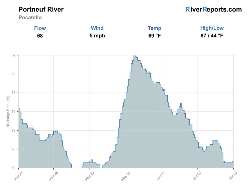
Showing the available RiverReports chart while the current structured flow series loads. Check the chart on RiverReports Opens in a new tab.
No single best way to fish. Wading and Floating have the same top score. Use current access, footing, weather, and local rules to choose.
Rating updatedRiver local time:
USGS shows 144 cfs. The flow has been stable over about 6 hours. USGS marks this reading provisional and may revise it. USGS records for this date (1899-2026, 116 readings) show a typical middle range of 133 cfs to 260 cfs. Flow is within the typical range for this date, so weather, temperature, and access become the next checks.
NWS air forecast near
This is an air forecast, not a river-temperature reading. Check the water with a stream thermometer before fishing in hot weather.
RiverReports gauge
Showing the available RiverReports chart while the current structured flow series loads. Check the chart on RiverReports Opens in a new tab.
Mostly Sunny
The National Weather Service forecast is temporarily unavailable.
RiverReports gauge: Portneuf River at Pocatello
Seasonal starting points, not a live hatch report. Match what you see on the water.
Each fly name opens its matching Fly Box guide.
The Portneuf is most useful when you enter with a section plan. It fishes best when you know whether you want the colder upper trout window or the easier lower public-access window, and when you are willing to leave once water quality, heat, or runoff undercut the day.
Best for wading selected seams and fishing deeper buckets without too much push or color.
Good for stealth and spotting structure, but fish can get selective and exposed in the easiest-access reaches.
Push upstream or skip the day. The lower river loses value fast when color and debris build.
Treat the Pocatello area cautiously and favor cooler upper sections if temperatures climb.
Wading and Floating have the same top score. Use current access, footing, weather, and local rules to choose.
Wading is in play only where your chosen access has clear footing, legal entry, and no forced crossings.
This report does not recommend bank fishing on this reach.
A float is in play where this report supports boat access and wind, releases, and shuttle logistics are manageable.
Is Portneuf River worth the trip today? Check flow, weather, hatches, access, and rules for Idaho before you go.
The Portneuf can be a worthwhile trout river when flows are manageable and you match your day to the right reach. The best planning split is simple: colder upper water around Lava Hot Springs for more trout focus, broader lower water around Pocatello for easier public access and more mixed uses.
USGS shows 144 cfs. The flow has been stable over about 6 hours. USGS marks this reading provisional and may revise it. USGS records for this date (1899-2026, 116 readings) show a typical middle range of 133 cfs to 260 cfs. Flow is within the typical range for this date, so weather, temperature, and access become the next checks.
Fall: Often the cleanest time for broad Portneuf planning and the best balance of access and trout focus.
The current NWS air forecast is about 51F, and the next 24-hour high reaches about 72F. Mostly Sunny.
No active NWS alert was returned for this forecast point.
Skip when the lower river is muddy or warm, or when runoff makes the upper river too pushy to fish safely from selected access points.
Moderate flows that keep upper-river seams defined and lower-river clarity good enough to trust what you are seeing.
Skip when the lower river is muddy or warm, or when runoff makes the upper river too pushy to fish safely from selected access points.
Choose upper or lower before you leave town, then let the gauge and the first access check confirm whether that decision still makes sense.
If the Portneuf lower area looks poor, head upstream toward colder water or switch to the Blackfoot or South Fork Snake depending on how much current and travel you want.
Use these places as starting points. Open the access link below and check posted signs before you park or enter.
IDFG's 2025-2027 special rule for the Portneuf River from above East Main Street Bridge in Lava Hot Springs upstream to Chesterfield Reservoir is catch-and-release, no bait, and barbless only from December 1 through the Friday before Memorial Day weekend. From the Saturday of Memorial Day weekend through November 30 the trout limit is 6 with no cutthroat harvest. Other sections outside the Fort Hall Reservation follow Southeast Region rules.
The best official lower-river access anchor near Pocatello for scouting and short floating or wading plans.
The cleaner trout-focused reference area when you want colder water and are prepared to follow the seasonal rule split.
Useful lower-river options when flows, clarity, and summer temperatures still make the urban area worthwhile.
Official agencies and primary river operators come first. Secondary tools are labeled so you know what carries the most weight.
Check what is allowed, where the rule applies, and whether the river is open.
Check the latest river reading and forecast before you leave.
Check public entry points, land rules, and seasonal access changes.
Check what is allowed, where the rule applies, and whether the river is open.
Open the current rules and check the river section, season, and special limits.
Check the latest river reading and forecast before you leave.
Open this page and check the latest safety advice before your trip.
Open this river reading to check the latest level, flow, and update time.
Open this river reading to check the latest level, flow, and update time.
Check public entry points, land rules, and seasonal access changes.
Open the land or access page, then check signs before you park or enter.
Open the land or access page, then check signs before you park or enter.
What was checked: This report uses official regulation, flow, weather, and public-access sources first, then adds practical planning guidance for fly anglers.
Live measurements and forecasts keep their provider timestamps. Rules, access, and trip guidance use the source-review date shown here. BlueStreamFly planning advice is editorial interpretation, not an agency notice.
First-hand experience: BlueStreamFly does not claim a first-hand visit or local field test for this report unless a real contributor is explicitly named and linked.
The Lava Hot Springs upstream section changes seasonally, including catch-and-release, no-bait, and barbless requirements from December 1 through the Friday before Memorial Day weekend.
Sometimes, especially at moderate flows with decent clarity, but it is not a blind-faith plan. If the lower area looks warm, muddy, or messy, move upstream or switch rivers.
Start with RiverReports and USGS 13075500 at Pocatello for lower-river trend context, then match that read to the exact section you plan to fish.