Wade, bank, and floatLimited data
Use the live sources and what you see at the river before choosing an approach.
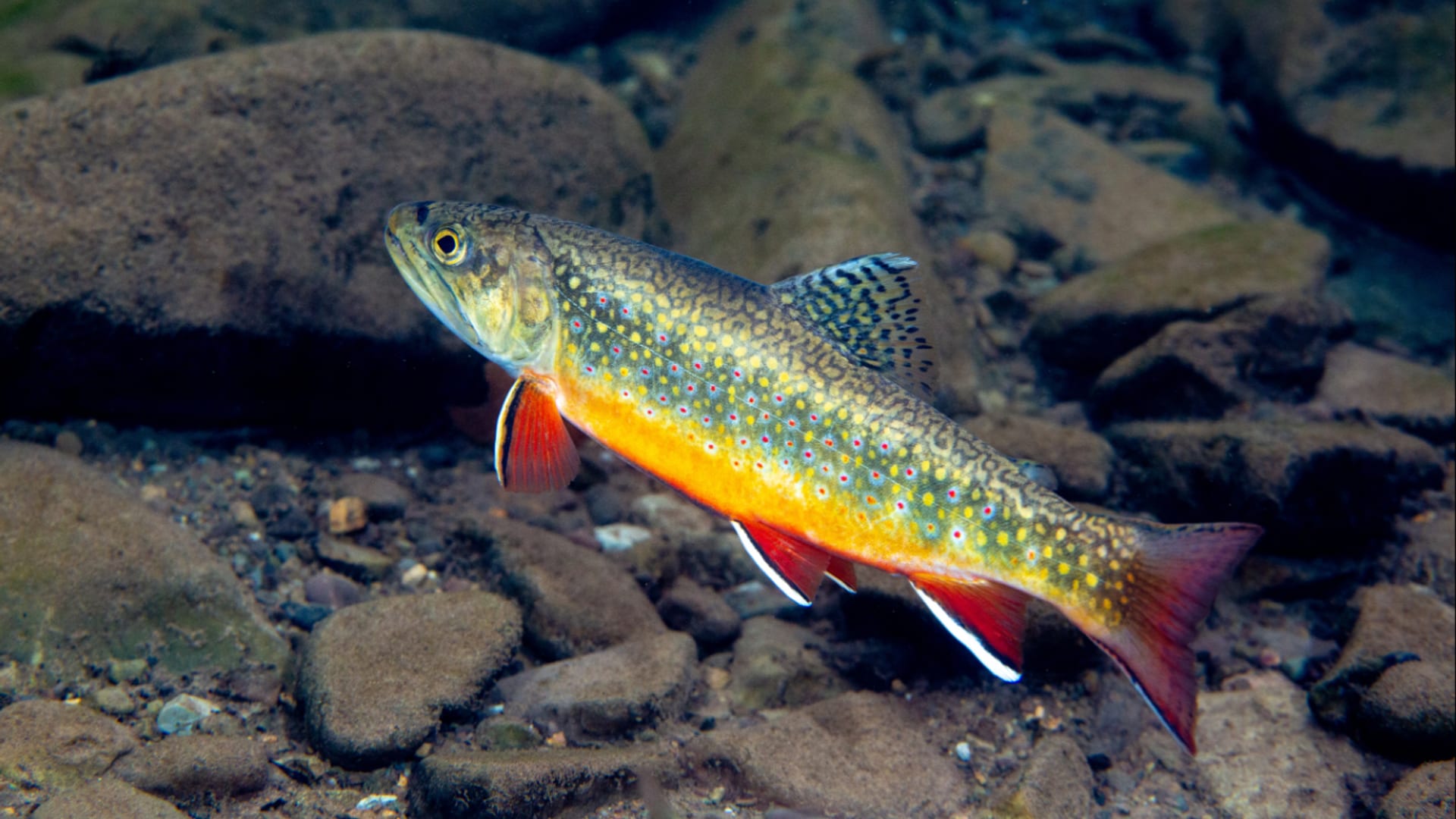
Fly fishing report · Southeast
A Seneca Rocks and backcountry planning report for Seneca Creek, with special-regulation guardrails, access context, hatches, and no-gauge flow guidance.
Check flow & weatherThis river does not have a reliable live gauge attached. Check the weather, recent rain, local reports, and the water when you arrive.
There is not enough reliable current information to recommend wading, bank fishing, or floating.
Use the live sources and what you see at the river before choosing an approach.
Check before you drive
Look at whether the river is rising or falling, then check wind, rain, and storms. These can change both safety and fishing.
Before you rely on this report
Conditions can change quickly. Check these dates before you decide to fish, and open the official source when safety or rules matter.
Medium confidence in the current score inputs.
7 sources are listed below for you to open.
3 public access records are listed. Private spots are never shown.
Source checked Jul 30, 2026
Plan your access
These are public parking, launch, trail, or recreation areas—not secret fishing spots. We never show an angler's private pins, notes, or photos here.
Area description
Use WVDNR and USFS sources to confirm the short special-regulation reach.
A direct current gauge was not verified for the fishing reach.
Backcountry water crossings can become unsafe after rain.
Trailhead
Backcountry access context where trail and weather planning matter.
A direct current gauge was not verified for the fishing reach.
Backcountry water crossings can become unsafe after rain.
Trailhead
A remote plan; do not assume easy exits or cell service.
A direct current gauge was not verified for the fishing reach.
Backcountry water crossings can become unsafe after rain.
How to fish it
Seneca Creek has a small special-regulation reach near Seneca Rocks and a separate mountain backcountry personality upstream. Do not use one rule, access point, or flow assumption for the whole creek.
No verified live public gauge is attached, so the page cannot make a strong real-time call.
The forecast has storm or heavy-precipitation risk, so timing and access matter more than the score alone.
A Flood Watch is active near this forecast point, so the score is capped until runoff, clarity, crossings, and road access are checked. NWS alert: Flood Watch issued August 2 at 9:54PM EDT until August 3 at 2:00AM EDT by NWS Baltimore MD/Washington DC.
Summer: Best in shaded, cool periods; watch temperature and crowds near easier access.
The NWS forecast is about 70F with Showers And Thunderstorms Likely.
Read the water
The best fishing comes when the creek is clear, cool, and not bank-full. If rain, snowmelt, or trail conditions are uncertain, stay near easier access or choose a gauged river.
Use dries, dry-droppers, and small nymphs through pocket water.
Fish edges only after the creek starts clearing and footing is safe.
Skip backcountry crossings and use the day for scouting.
Fish early, check temperature, and stop before trout handling becomes stressful.
Your trip plan
No verified current public gauge is used for the fishing reach. Use recent rain, field clarity, trail condition, the National Weather Service point, and an on-site temperature check before committing.
Skip or change the plan when water is rising or opaque, special-regulation boundaries are unclear, trails are muddy or storm-damaged, crossings are risky, summer water is warm, or the day depends on one crowded roadside pool.
Choose the mouth reach or the backcountry first, then pair WVDNR rule checks with USFS trail status, weather, water treatment, and a realistic exit time before selecting flies.
If Seneca Creek is high, warm, unclear, crowded, or trail-limited, compare Shavers Fork River, Elk River, or Second Creek before forcing the same plan.
Hatches & flies
 Fly family · report suggests “Quill Gordon”Quill Gordon PatternsQuill Gordon may refer to the eastern Epeorus pleuralis hatch, a stage-specific imitation, or the traditional Gordon dry. The photographed natural aquatic forms have a broad flattened head and body, paired wing pads, plate-like side gills, long legs, a tapered abdomen, and two tails. Those clues do not identify the adult dry, prove a local population, or turn every gray quill-bodied fly into the exact traditional pattern.See family guide ↗
 Fly family · report suggests “Blue Quill”Blue Quill PatternsBlue Quill is hatch wording rather than one mandatory recipe. The traditional dry is only one adult imitation; subsurface and spent stages need different profiles.See family guide ↗+ 3 more reviewed guides in the Fly Box
  Fly family · report suggests “March Brown”March Brown Dry FliesThis family includes traditional hackled, parachute, and Comparadun-style March Brown dries. Each exact construction rides differently and should be named when known.See family guide ↗
 Fly family · report suggests “sulphur emerger”Sulphur Mayfly PatternsSulphur is hatch wording. Nymphs, emergers, Comparaduns, parachutes, traditional dries, soft hackles, and spinners have different silhouettes and depths.See family guide ↗+ 3 more reviewed guides in the Fly Box
  Fly family · report suggests “Foam ant”Ant PatternsAnt patterns can be foam, fur-bodied, winged, or sunken. The narrow waist and paired body lobes matter more than one material recipe.See family guide ↗
 Fly family · report suggests “beetle”Beetle PatternsBeetle flies range from simple foam shells to hair-bodied and sunken forms. A rounded back and compact profile distinguish the family from ants and hoppers.See family guide ↗+ 3 more reviewed guides in the Fly Box
  Fly family · report suggests “BWO emerger”Blue-Winged Olive PatternsBWO describes a hatch group, not one fly. Nymph, emerger, dry, cripple, and spinner profiles must stay separate because they occupy different parts of the water column.See family guide ↗
 Fly family · report suggests “midge pupa”Midge Patterns by StageMidge wording can mean a threadlike larva, wing-padded pupa, film emerger, tiny adult, or visible cluster. Those profiles fish at different depths.See family guide ↗+ 3 more reviewed guides in the Fly Box
 Treat the mouth and backcountry sections as separate plans with separate access risk.
Fish dry-droppers through pocket water and switch to a single dry when trout look up.
Use small streamers only when water is safely up and slightly stained.
Step around shallow spawning or nursery water and keep fish in the water.
Carry enough time to hike out before dark if you leave the road corridor.
Rules & closures
Open the agency page to confirm the exact river section, species, season, tackle rules, limits, and emergency closures.
Official links checkedWe checked the state source but did not find a clearly supported exception for this river. Check the official rules for the exact section you plan to fish.
This summary helps with trip planning. The linked agency rule is the one you must follow.
Updates from anglers
Recent observations from general areas of Seneca Creek. We review every update before it appears and never publish exact fishing spots, private access details, or photo locations.
You can still use the river plan above. Check back later for recent observations from other anglers.
Where this report comes from
Fishing guidance checked: Jul 6, 2026
Site check: Jul 14, 2026. We regularly test report links, live scores, flow and weather data, and page loading. The content date changes only when the fishing guidance or its sources change.
Common questions
WVDNR regulations, Monongahela access status, recent rain, trail conditions, and weather
There is no direct current Seneca Creek gauge used here. Use recent rain, trail reports, and on-site clarity instead of a misleading nearby substitute.
Start at Seneca Rocks for the short mouth-area plan, or build a separate backcountry plan through Monongahela National Forest access sources.
Yes in normal clear flows, but crossings become risky after rain and in cold high water.