RiverReports chart
Recent flow
RiverReports gauge
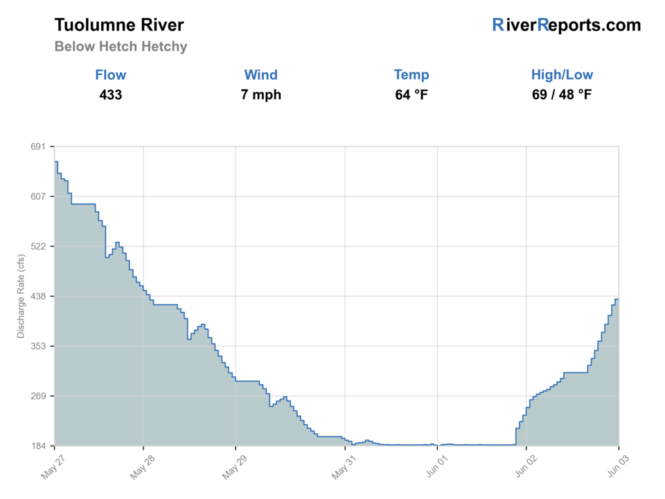
BlueStreamFly cannot read the latest value from this image. Check the chart on RiverReports Opens in a new tab.
Best option: Floating. A float is in play where this report supports boat access and wind, releases, and shuttle logistics are manageable.
Check first: No structured live flow
Rating updatedRiver local time:
RiverReports is linked for the flow chart, but this page does not have a structured live flow value the score can read automatically. Treat the rating as conservative and open the chart before committing.
NWS air forecast near
This is an air forecast, not a river-temperature reading. Check the water with a stream thermometer before fishing in hot weather.
RiverReports gauge
BlueStreamFly cannot read the latest value from this image. Check the chart on RiverReports Opens in a new tab.
Mostly Clear
The National Weather Service forecast is temporarily unavailable.
RiverReports gauge: Tuolumne River below Hetch Hetchy
Seasonal starting points, not a live hatch report. Match what you see on the water.
Each fly name opens its matching Fly Box guide.
Best windows come with stable flow, cool water, and access that does not require unsafe crossings. Skip the trip when the gauge rises fast, roads are uncertain, or water is too warm.
Best for careful canyon trout fishing where access is legal.
Do not wade if flow or release timing is uncertain.
Treat closures and posted rules as trip-stoppers.
Fish early or choose a cooler backup.
These scores compare the risks of wading, bank fishing, and floating.
Wading is in play only where your chosen access has clear footing, legal entry, and no forced crossings.
This report does not recommend bank fishing on this reach.
A float is in play where this report supports boat access and wind, releases, and shuttle logistics are manageable.
Is Tuolumne River below Hetch Hetchy worth the trip today? Check flow, weather, hatches, access, and rules for California before you go.
Tuolumne River below Hetch Hetchy should be planned around flow, legal access, and the specific reach you intend to fish. The best plan is built around safe flow, legal access, water temperature, and short realistic reaches instead of trying to cover the whole drainage.
RiverReports is linked for the flow chart, but this page does not have a structured live flow value the score can read automatically. Treat the rating as conservative and open the chart before committing.
Float: A float is in play where this report supports boat access and wind, releases, and shuttle logistics are manageable.
Fall: Cooler nights, lower pressure, and stable water can create the cleanest trout fishing.
The current NWS air forecast is about 41F, and the next 24-hour high reaches about 60F. Mostly Clear.
No active NWS alert was returned for this forecast point.
Stable, clear, cool water with safe crossings and enough depth to hold trout in pockets.
Skip during sharp rises, hot low water, unsafe crossings, or road and trail uncertainty.
Hetch Hetchy, Mather, or Groveland is the practical base. Check nps hetch hetchy rules, riverreports chart, blm/forest notices, cdfw rules, and weather, then pick a short legal access plan instead of trying to cover the whole river.
Check nearby BlueStreamFly reports if the gauge, rules, or weather do not fit the plan.
Use these places as starting points. Open the access link below and check posted signs before you park or enter.
Check current CDFW inland trout rules plus park, forest, or BLM notices before fishing. Rules can vary by reach and season.
NPS restrictions and entry rules control the first planning decision.
BLM and forest context helps, but canyon access is demanding.
Use as a logistics base, not as proof of easy access.
Official agencies and primary river operators come first. Secondary tools are labeled so you know what carries the most weight.
Check what is allowed, where the rule applies, and whether the river is open.
Check the latest river reading and forecast before you leave.
Check public entry points, land rules, and seasonal access changes.
Use these links for stocking, safety, and other local details.
Check what is allowed, where the rule applies, and whether the river is open.
Open the current rules and check the river section, season, and special limits.
Open the current rules and check the river section, season, and special limits.
Check the latest river reading and forecast before you leave.
Open this page and check the latest safety advice before your trip.
Open this river reading to check the latest level, flow, and update time.
Check public entry points, land rules, and seasonal access changes.
Open the land or access page, then check signs before you park or enter.
Open the land or access page, then check signs before you park or enter.
Use these links for stocking, safety, and other local details.
Open this page for more river information and check when it was last updated.
What was checked: This report uses official regulation, flow, weather, access, and public-source material first, then adds practical angler planning guidance without replacing current rules.
Live measurements and forecasts keep their provider timestamps. Rules, access, and trip guidance use the source-review date shown here. BlueStreamFly planning advice is editorial interpretation, not an agency notice.
First-hand experience: BlueStreamFly does not claim a first-hand visit or local field test for this report unless a real contributor is explicitly named and linked.
Check current CDFW rules and land-management notices first. This page gives planning context, but legal status comes from current rules.
Wade-and-move is the baseline. Float only where you have whitewater skill, legal access, and a safe takeout.
Use the RiverReports chart for a fast read, then verify conditions with the listed park, forest, or water-management sources before fishing.