WadeNot advised
Wading is the most sensitive plan today. Use protected edges only, avoid crossings, and downgrade quickly if clarity or current feels wrong.

Fly fishing report · Northeast
A northwestern Pennsylvania report for anglers planning Oil Creek around delayed-harvest water, state-park access, flows, and warm-versus-cool-water timing.
Check flow & weatherThe forecast has storm or heavy-precipitation risk, so timing and access matter more than the score alone.
Compare wading, bank fishing, and floating before choosing how you will fish.
Wading is the most sensitive plan today. Use protected edges only, avoid crossings, and downgrade quickly if clarity or current feels wrong.
This report does not describe this as a primary mode. Verify legal access, depth, launches, and retreat options before planning around it.
A float can fit better than wading only if launches, shuttle, boat skill, wind, and local rules all check out.
Check before you drive
Look at whether the river is rising or falling, then check wind, rain, and storms. These can change both safety and fishing.
Before you rely on this report
Conditions can change quickly. Check these dates before you decide to fish, and open the official source when safety or rules matter.
High confidence in the current score inputs.
8 sources are listed below for you to open.
4 public access records are listed. Private spots are never shown.
Source checked Jul 30, 2026
Plan your access
These are public parking, launch, trail, or recreation areas—not secret fishing spots. We never show an angler's private pins, notes, or photos here.
Trailhead
A practical central park base for nearby creek access, bike trail use, and quick flow checks.
The park is open sunrise to sunset, and day-use areas close at dusk.
Use only signed public access and treat tributary pull-offs carefully; some of the valley is straightforward, but not every roadside break is public.
Day use
Useful public pull-offs on the south side of the park for walk-in access and short sessions.
The park is open sunrise to sunset, and day-use areas close at dusk.
Use only signed public access and treat tributary pull-offs carefully; some of the valley is straightforward, but not every roadside break is public.
Area description
Tributary scouting options when the main creek is too warm or you want smaller brook-trout water.
The park is open sunrise to sunset, and day-use areas close at dusk.
Use only signed public access and treat tributary pull-offs carefully; some of the valley is straightforward, but not every roadside break is public.
Boat launch
Relevant only when you have legal boat permits and levels fit DCNR's guidance.
The park is open sunrise to sunset, and day-use areas close at dusk.
Use only signed public access and treat tributary pull-offs carefully; some of the valley is straightforward, but not every roadside break is public.
How to fish it
Oil Creek is one of the easier Pennsylvania planning pages to use because the park, the gauge, and the regulation structure line up well. Start with the Rouseville flow, decide whether you want delayed-harvest trout water or broader mixed-species water, and keep current speed and water temperature honest before you wade.
The forecast has storm or heavy-precipitation risk, so timing and access matter more than the score alone.
A Flood Watch is active near this forecast point, so the score is capped until runoff, clarity, crossings, and road access are checked. NWS alert: Flood Watch issued August 2 at 1:45PM EDT until August 3 at 12:00AM EDT by NWS Pittsburgh PA.
Float: A float can fit better than wading only if launches, shuttle, boat skill, wind, and local rules all check out.
USGS shows 90 cfs with a rising about 18% over about 6 hours trend. Today's flow is within the normal seasonal range of 65 cfs to 152 cfs. Weather, water temperature, and access are the next checks.
Late spring to early summer: Usually the strongest trout window for delayed-harvest structure, caddis, and mixed hatch activity.
Read the water
The best fishing window is usually stable or slowly falling flow with enough color to cover water but not enough push to limit wading. Skip the trout plan when the creek is warm, muddy, or pushing above your safe wading comfort level.
Best for covering delayed-harvest runs with nymphs, caddis, and small streamers.
Fish early, monitor temperature, and shift toward bass or tributary scouting if trout water warms.
Hold off on wading and let clarity return before forcing the day.
Useful for boaters with the right permits and skill, but often a poor wading setup.
Your trip plan
Stable or gently dropping levels that leave enough edge and clarity for nymphs and dry-droppers without pushing you off the bank.
Skip trout fishing in warm summer water, after muddy rain spikes, or when current is high enough that you are guessing at exits.
Base near Oil City, Titusville, or Petroleum Centre, check the Rouseville gauge, then decide between delayed-harvest trout water and a bass-oriented backup.
Kettle Creek is the colder trout backup, while Slippery Rock Creek is the western Pennsylvania alternative when you want a different regulation mix.
Hatches & flies
 Fly pattern · report suggests “Zebra midge”Zebra MidgeLook for a very slim tapered thread body, evenly spaced contrasting wire rib, a small bead, and no tail or wing. The reviewed classic is black with silver wire and a silver bead. Red, olive, brown, glass-bead, jig-hook, resin-coated, or tailed forms must remain labeled variations rather than replacing the classic identity.See photos & how to fish it ↗
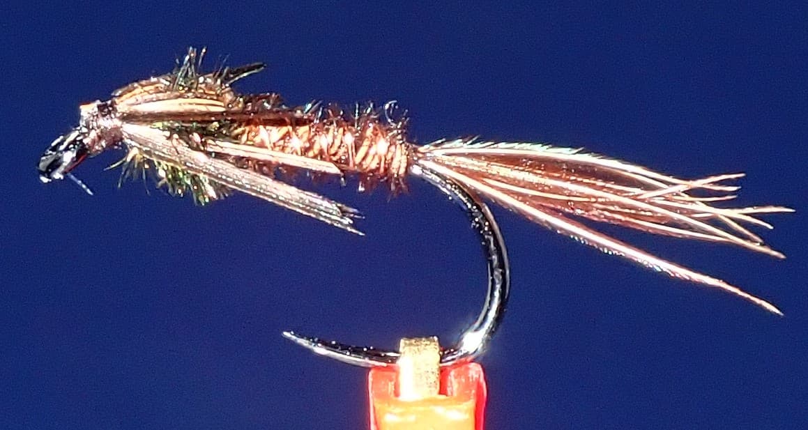 Fly pattern · report suggests “pheasant tail”Pheasant Tail NymphThe pilot page distinguishes the sparse original idea from the bulkier American form. Both use pheasant-tail fibers and copper wire, but bead heads, peacock-herl thoraxes, legs, flashbacks, jig hooks, and soft-hackle collars are variations that must be labeled.See photos & how to fish it ↗+ 2 more reviewed guides in the Fly Box
  Fly pattern · report suggests “Elk hair caddis”Elk Hair CaddisLook for a tented elk- or deer-hair wing, clipped hair head, dubbed body, rib, and hackle palmered along the body. The body color should be labeled because tiers often match different natural caddis colors.See photos & how to fish it ↗
 Fly family · report suggests “soft hackle”Soft-Hackle Wet FliesA slim body and sparse webby feather collar define the family. Body material, tail, bead, and insect-specific color create different named patterns.See family guide ↗+ 2 more reviewed guides in the Fly Box
  Fly family · report suggests “Foam ant”Ant PatternsAnt patterns can be foam, fur-bodied, winged, or sunken. The narrow waist and paired body lobes matter more than one material recipe.See family guide ↗
 Fly family · report suggests “beetle”Beetle PatternsBeetle flies range from simple foam shells to hair-bodied and sunken forms. A rounded back and compact profile distinguish the family from ants and hoppers.See family guide ↗+ 2 more reviewed guides in the Fly Box
  Fly family · report suggests “BWO comparadun”Blue-Winged Olive PatternsBWO describes a hatch group, not one fly. Nymph, emerger, dry, cripple, and spinner profiles must stay separate because they occupy different parts of the water column.See family guide ↗Fly family · report suggests “soft hackle”Soft-Hackle Wet FliesA slim body and sparse webby feather collar define the family. Body material, tail, bead, and insect-specific color create different named patterns.See family guide ↗+ 2 more reviewed guides in the Fly Box
 Split the creek into two plans: delayed-harvest trout water when temperatures and clarity cooperate, or broader mixed-species water when summer warmth pushes trout management into the background.
Use the Rouseville gauge first, then confirm whether your chosen access has enough room for a safe entry and exit. Oil Creek fishes smaller than some of its drainage numbers suggest once banks tighten up.
A dry-dropper or light two-fly nymph rig covers most productive water. Save streamers for stained water, lower light, or bass-oriented stretches.
If the main stem is too warm, too high, or too crowded, scout the park's named brook-trout tributaries only where access and posted rules are clear.
Rules & closures
Open the agency page to confirm the exact river section, species, season, tackle rules, limits, and emergency closures.
Official links checkedWe checked the state source but did not find a clearly supported exception for this river. Check the official rules for the exact section you plan to fish.
This summary helps with trip planning. The linked agency rule is the one you must follow.
Updates from anglers
Recent observations from general areas of Oil Creek. We review every update before it appears and never publish exact fishing spots, private access details, or photo locations.
You can still use the river plan above. Check back later for recent observations from other anglers.
Where this report comes from
Fishing guidance checked: Jun 2, 2026
Site check: Jul 14, 2026. We regularly test report links, live scores, flow and weather data, and page loading. The content date changes only when the fishing guidance or its sources change.
Common questions
Use RiverReports for the quick chart and USGS 03020500 at Rouseville as the official flow reference.
It is a trout-and-bass river. Trout planning matters most in the delayed-harvest water and cooler months, while bass becomes a smarter fallback in warm periods.
Yes, but only with the right permit and only when levels fit park guidance. DCNR recommends at least 2.75 feet for kayaks, 3.0 feet for canoes, and says 5.0 feet or more is not recommended.