WadeNot advised
Wading is the most sensitive plan today. Use protected edges only, avoid crossings, and downgrade quickly if clarity or current feels wrong.

Fly fishing report · Southeast
A Linville River report for anglers checking gorge access, steep terrain, flows, NC trout rules, hatches, and when to choose a safer backup plan.
Check flow & weatherCurrent USGS flow is 232 cfs. It has risen about 22% over the past 6 hours. Today's flow is above the usual high-water marker for this date; the seasonal median is 62 cfs. Treat this as high-water fishing: wading, clarity, crossings, and boat control need a conservative check.
Compare wading, bank fishing, and floating before choosing how you will fish.
Wading is the most sensitive plan today. Use protected edges only, avoid crossings, and downgrade quickly if clarity or current feels wrong.
This report does not describe this as a primary mode. Verify legal access, depth, launches, and retreat options before planning around it.
A float can fit better than wading only if launches, shuttle, boat skill, wind, and local rules all check out.
Check before you drive
Look at whether the river is rising or falling, then check wind, rain, and storms. These can change both safety and fishing.
Before you rely on this report
Conditions can change quickly. Check these dates before you decide to fish, and open the official source when safety or rules matter.
High confidence in the current score inputs.
7 sources are listed below for you to open.
3 public access records are listed. Private spots are never shown.
Source checked Jul 30, 2026
Plan your access
These are public parking, launch, trail, or recreation areas—not secret fishing spots. We never show an angler's private pins, notes, or photos here.
Trailhead
Check Forest Service conditions, closures, permits, and trail status before committing.
Gorge trails are steep, primitive, and not always signed or blazed.
Some routes require wet crossings or may be affected by storm damage.
Trailhead
Useful for gorge orientation and road/trail planning, not automatic river access.
Gorge trails are steep, primitive, and not always signed or blazed.
Some routes require wet crossings or may be affected by storm damage.
Area description
Use the gauge to judge whether the river is safe before driving into more difficult access.
Gorge trails are steep, primitive, and not always signed or blazed.
Some routes require wet crossings or may be affected by storm damage.
How to fish it
The Linville River can be beautiful and productive, but the gorge makes access and safety the first decision. Check the gauge, Forest Service conditions, NCWRC rules, and weather before you decide whether to fish, scout from above, or pick an easier river.
USGS shows 232 cfs with a rising about 22% over about 6 hours trend. Today's flow is above the usual high-water marker for this date; the seasonal median is 62 cfs. Treat this as high-water fishing: wading, clarity, crossings, and boat control need a conservative check.
The forecast has storm or heavy-precipitation risk, so timing and access matter more than the score alone.
Float: A float can fit better than wading only if launches, shuttle, boat skill, wind, and local rules all check out.
Summer: Early and shaded windows matter; heat and storms can narrow the day.
The NWS forecast is about 72F with Showers And Thunderstorms Likely.
Read the water
Best fishing windows are stable, clear, and safe enough to approach without rushing. High water, thunderstorms, poor trail information, or limited daylight should push the plan toward easier nearby water.
Best for careful pocket-water nymphing and dry-dropper fishing.
Avoid wading and steep descents. The terrain raises the consequence of a bad decision.
Fish shaded pockets, long leaders, and quiet approaches.
Leave early or choose another river; gorge escape routes take time.
Your trip plan
Clear moderate flows that leave safe entries and enough pocket-water depth without making crossings dangerous.
Skip during high water, storms, poor trail conditions, late starts, or limited daylight.
Base near Linville Falls, Marion, Morganton, or Nebo; check the gauge and Forest Service conditions before choosing access.
Catawba, Davidson, and Nantahala pages give safer alternatives when Linville is too high or the access window is poor.
Hatches & flies
 Fly pattern · report suggests “Zebra midge”Zebra MidgeLook for a very slim tapered thread body, evenly spaced contrasting wire rib, a small bead, and no tail or wing. The reviewed classic is black with silver wire and a silver bead. Red, olive, brown, glass-bead, jig-hook, resin-coated, or tailed forms must remain labeled variations rather than replacing the classic identity.See photos & how to fish it ↗
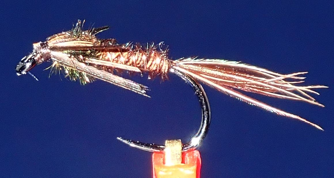 Fly pattern · report suggests “pheasant tail”Pheasant Tail NymphThe pilot page distinguishes the sparse original idea from the bulkier American form. Both use pheasant-tail fibers and copper wire, but bead heads, peacock-herl thoraxes, legs, flashbacks, jig hooks, and soft-hackle collars are variations that must be labeled.See photos & how to fish it ↗+ 1 more reviewed guide in the Fly Box
  Fly pattern · report suggests “Elk hair caddis”Elk Hair CaddisLook for a tented elk- or deer-hair wing, clipped hair head, dubbed body, rib, and hackle palmered along the body. The body color should be labeled because tiers often match different natural caddis colors.See photos & how to fish it ↗
 Fly pattern · report suggests “stimulator”StimulatorLook for a hair tail, dubbed abdomen with palmered hackle, tented hair wing, contrasting front hackle, and bright thorax or head. Colors and sizes vary widely and must remain labeled.See photos & how to fish it ↗+ 1 more reviewed guide in the Fly Box
  Fly family · report suggests “Ant”Ant PatternsAnt patterns can be foam, fur-bodied, winged, or sunken. The narrow waist and paired body lobes matter more than one material recipe.See family guide ↗
 Fly family · report suggests “beetle”Beetle PatternsBeetle flies range from simple foam shells to hair-bodied and sunken forms. A rounded back and compact profile distinguish the family from ants and hoppers.See family guide ↗+ 1 more reviewed guide in the Fly Box
  Fly family · report suggests “BWO emerger”Blue-Winged Olive PatternsBWO describes a hatch group, not one fly. Nymph, emerger, dry, cripple, and spinner profiles must stay separate because they occupy different parts of the water column.See family guide ↗
 Fly family · report suggests “soft hackle”Soft-Hackle Wet FliesA slim body and sparse webby feather collar define the family. Body material, tail, bead, and insect-specific color create different named patterns.See family guide ↗+ 1 more reviewed guide in the Fly Box
 Decide whether the access is safe before deciding what to fish.
Fish short pockets and boulder edges from stable footing; do not chase one more cast into unsafe current.
Move slowly and fish upstream where possible to avoid spooking clear-water fish.
Turn around early if weather, daylight, or trail conditions change.
Rules & closures
Open the agency page to confirm the exact river section, species, season, tackle rules, limits, and emergency closures.
Official links checkedWe checked the state source but did not find a clearly supported exception for this river. Check the official rules for the exact section you plan to fish.
This summary helps with trip planning. The linked agency rule is the one you must follow.
Updates from anglers
Recent observations from general areas of Linville River. We review every update before it appears and never publish exact fishing spots, private access details, or photo locations.
You can still use the river plan above. Check back later for recent observations from other anglers.
Where this report comes from
Fishing guidance checked: Jun 2, 2026
Site check: Jul 14, 2026. We regularly test report links, live scores, flow and weather data, and page loading. The content date changes only when the fishing guidance or its sources change.
Common questions
Use RiverReports for the quick chart and USGS 02138500 near Nebo for the official gauge reference.
No. Many routes are steep, primitive, and condition-dependent. Check Forest Service information before committing.
Choose another river during high water, storm threats, poor trail conditions, late starts, or when your group is not prepared for gorge travel.