Wade · Best fit82/100
Wading is in play only where your chosen access has clear footing, legal entry, and no forced crossings.

Fly fishing report · Northeast
A White Mountains and central New Hampshire report for anglers checking flows, access, water temperature, and trout tactics before fishing the Pemi.
Check flow & weatherCurrent USGS flow is 91 cfs and has been stable for about 6 hours. Today's flow is below the normal seasonal range, which begins near 110 cfs. This is below normal, so edge depth, temperature, and pressure matter.
Compare wading, bank fishing, and floating before choosing how you will fish.
Wading is in play only where your chosen access has clear footing, legal entry, and no forced crossings.
This report does not describe this as a primary mode. Verify legal access, depth, launches, and retreat options before planning around it.
This report does not describe this as a primary mode. Verify legal access, depth, launches, and retreat options before planning around it.
Check before you drive
Look at whether the river is rising or falling, then check wind, rain, and storms. These can change both safety and fishing.
Before you rely on this report
Conditions can change quickly. Check these dates before you decide to fish, and open the official source when safety or rules matter.
High confidence in the current score inputs.
6 sources are listed below for you to open.
3 public access records are listed. Private spots are never shown.
Source checked Jul 30, 2026
Plan your access
These are public parking, launch, trail, or recreation areas—not secret fishing spots. We never show an angler's private pins, notes, or photos here.
Roadside access
Use town access, road pullouts, and posted rules; the river changes quickly around bridges and ledge.
Public-looking water is not always public access. Use signed access, public land, or clear permission.
National Forest sites can be excellent bases, but some are day-use only or have seasonal service limits.
Parking
Check recreation-site hours, fees, parking, and facilities before relying on a specific access.
Public-looking water is not always public access. Use signed access, public land, or clear permission.
National Forest sites can be excellent bases, but some are day-use only or have seasonal service limits.
Day use
A lower-valley planning zone with day-use and roadside options; confirm posted access before fishing.
Public-looking water is not always public access. Use signed access, public land, or clear permission.
National Forest sites can be excellent bases, but some are day-use only or have seasonal service limits.
How to fish it
The Pemigewasset can look friendly from the road, but the best fly-fishing plan starts with the Woodstock gauge, the weather, and the specific access you intend to use. Cold pockets, shaded tributary influence, and morning windows matter more than a generic statewide trout plan.
USGS shows 91 cfs with a stable over about 6 hours trend. Today's flow is below the normal seasonal range, which begins near 110 cfs. This is below normal, so edge depth, temperature, and pressure matter.
Early summer: Often the most balanced window for hatches, access, and trout-friendly temperatures.
The NWS forecast is about 71F with Cloudy.
No active NWS alert was returned for this forecast point.
Skip trout fishing during rising runoff, hot low-water afternoons, thunderstorms, poor clarity, or uncertain access.
Read the water
Best conditions are usually stable to gently falling flows, clear enough water to see the first shelf, and cool weather that keeps trout handling reasonable. After heavy rain, snowmelt, or thunderstorms, wait for the gauge and clarity to settle before wading.
Best for dry-dropper fishing, light nymphing, and careful pocket-water work.
Skip wading and wait. The river can gain speed faster than it looks from the road.
Fish early, carry a thermometer, and move away from stressed trout.
Use larger nymphs or small streamers tight to softer banks and seams.
Your trip plan
Stable or gently falling flows that leave visible edges, readable pocket water, and safe entries at public access.
Skip trout fishing during rising runoff, hot low-water afternoons, thunderstorms, poor clarity, or uncertain access.
Base in Lincoln, Woodstock, Plymouth, or Campton; check the gauge first, then choose upper cold-water access or lower mixed-water access.
Saco River, Merrimack River, and Androscoggin River pages give nearby alternatives when the Pemi is high, warm, or crowded.
Hatches & flies
 Fly pattern · report suggests “Zebra midge”Zebra MidgeLook for a very slim tapered thread body, evenly spaced contrasting wire rib, a small bead, and no tail or wing. The reviewed classic is black with silver wire and a silver bead. Red, olive, brown, glass-bead, jig-hook, resin-coated, or tailed forms must remain labeled variations rather than replacing the classic identity.See photos & how to fish it ↗
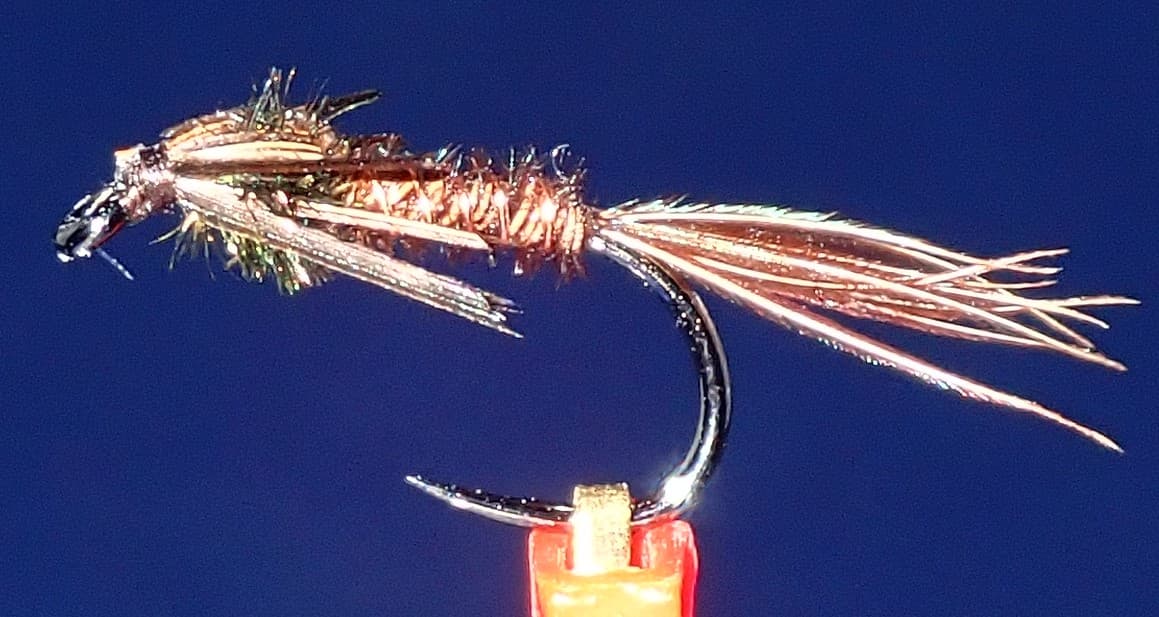 Fly pattern · report suggests “pheasant tail”Pheasant Tail NymphThe pilot page distinguishes the sparse original idea from the bulkier American form. Both use pheasant-tail fibers and copper wire, but bead heads, peacock-herl thoraxes, legs, flashbacks, jig hooks, and soft-hackle collars are variations that must be labeled.See photos & how to fish it ↗+ 2 more reviewed guides in the Fly Box
  Fly pattern · report suggests “Elk hair caddis”Elk Hair CaddisLook for a tented elk- or deer-hair wing, clipped hair head, dubbed body, rib, and hackle palmered along the body. The body color should be labeled because tiers often match different natural caddis colors.See photos & how to fish it ↗
 Fly family · report suggests “soft hackle”Soft-Hackle Wet FliesA slim body and sparse webby feather collar define the family. Body material, tail, bead, and insect-specific color create different named patterns.See family guide ↗+ 2 more reviewed guides in the Fly Box
  Fly family · report suggests “Foam ant”Ant PatternsAnt patterns can be foam, fur-bodied, winged, or sunken. The narrow waist and paired body lobes matter more than one material recipe.See family guide ↗
 Fly family · report suggests “beetle”Beetle PatternsBeetle flies range from simple foam shells to hair-bodied and sunken forms. A rounded back and compact profile distinguish the family from ants and hoppers.See family guide ↗+ 1 more reviewed guide in the Fly Box
  Fly family · report suggests “BWO emerger”Blue-Winged Olive PatternsBWO describes a hatch group, not one fly. Nymph, emerger, dry, cripple, and spinner profiles must stay separate because they occupy different parts of the water column.See family guide ↗Fly family · report suggests “soft hackle”Soft-Hackle Wet FliesA slim body and sparse webby feather collar define the family. Body material, tail, bead, and insect-specific color create different named patterns.See family guide ↗+ 1 more reviewed guide in the Fly Box
 Start with the Woodstock gauge, then match the reach to the flow. Big water near town and smaller upper water fish very differently.
In broken pocket water, fish short drifts and move often. One careful cast to each soft edge beats long blind casting.
In low summer water, fish early or switch targets rather than grinding on warm trout.
Keep a backup plan. Nearby White Mountains water can fish better than the main stem after storms.
Rules & closures
Open the agency page to confirm the exact river section, species, season, tackle rules, limits, and emergency closures.
Official links checkedWe checked the state source but did not find a clearly supported exception for this river. Check the official rules for the exact section you plan to fish.
This summary helps with trip planning. The linked agency rule is the one you must follow.
Updates from anglers
Recent observations from general areas of Pemigewasset River. We review every update before it appears and never publish exact fishing spots, private access details, or photo locations.
You can still use the river plan above. Check back later for recent observations from other anglers.
Where this report comes from
Fishing guidance checked: Jun 2, 2026
Site check: Jul 14, 2026. We regularly test report links, live scores, flow and weather data, and page loading. The content date changes only when the fishing guidance or its sources change.
Common questions
Use RiverReports for the quick chart and USGS 01075000 at Woodstock for the official gauge reference.
Most visiting fly anglers plan around wading and roadside access, but high flows can make wading unsafe. Match your plan to the gauge and the exact reach.
Skip when flows are rising, water is too warm, clarity is poor, or access is unclear. A nearby smaller stream or a scouting day is often smarter.