RiverReports preview · current series loading
Recent flow
RiverReports gauge
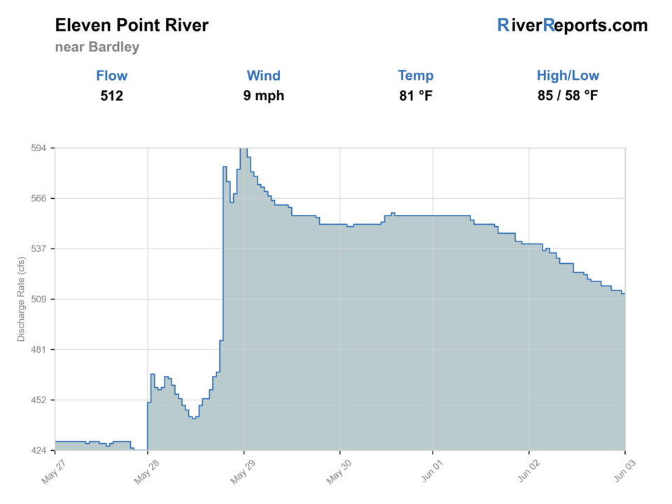
Showing the available RiverReports chart while the current structured flow series loads. Check the chart on RiverReports Opens in a new tab.
No single best way to fish. Wading and Floating have the same top score. Use current access, footing, weather, and local rules to choose.
Rating updatedRiver local time:
USGS shows 271 cfs. The flow has been stable over about 6 hours. USGS marks this reading provisional and may revise it. USGS records for this date (1922-2026, 105 readings) show a median near 374 cfs and the lower quartile near 296 cfs; today's flow is below normal for the date. This is below normal, so edge depth, temperature, and pressure matter.
NWS air forecast near
This is an air forecast, not a river-temperature reading. Check the water with a stream thermometer before fishing in hot weather.
RiverReports gauge
Showing the available RiverReports chart while the current structured flow series loads. Check the chart on RiverReports Opens in a new tab.
Sunny
The National Weather Service forecast is temporarily unavailable.
RiverReports gauge: Eleven Point River near Bardley
Seasonal starting points, not a live hatch report. Match what you see on the water.
Also try hopper-dropper
Each fly name opens its matching Fly Box guide.
The Eleven Point is strongest when you either have enough water to float the smallmouth water cleanly or enough clarity and moderate current to fish the trout sections around Greer and Turner Mill deliberately. It loses value when levels get too low for the upper float, when summer traffic turns the obvious accesses into a parade, or when anglers mix warmwater expectations with the trout-only rules.
Best for covering the upper river from Thomasville toward Greer without dragging boats over riffles.
Ideal for the Greer-to-Turner Blue Ribbon stretch and the stocked White Ribbon water below.
Usually pushes you toward shorter trout-focused sessions or selective upper-river wading instead of long floats.
Fish early, choose less obvious access transitions, or shift to a weekday plan.
Wading and Floating have the same top score. Use current access, footing, weather, and local rules to choose.
Wading is in play only where your chosen access has clear footing, legal entry, and no forced crossings.
This report does not recommend bank fishing on this reach.
A float is in play where this report supports boat access and wind, releases, and shuttle logistics are manageable.
Is Eleven Point River worth the trip today? Check flow, weather, hatches, access, and rules for Missouri before you go.
The upper river above Greer fishes like an Ozark smallmouth and goggle-eye float when levels are healthy, while the Greer Spring branch turns the middle river into a colder trout system with tighter rules and clearer wade decisions. The best days start by choosing which version of the river you actually want.
USGS shows 271 cfs. The flow has been stable over about 6 hours. USGS marks this reading provisional and may revise it. USGS records for this date (1922-2026, 105 readings) show a median near 374 cfs and the lower quartile near 296 cfs; today's flow is below normal for the date. This is below normal, so edge depth, temperature, and pressure matter.
Fall: A good reset for both trout and lower-river predator fishing when crowds thin and temperatures stabilize.
The current NWS air forecast is about 53F, and the next 24-hour high reaches about 79F. Sunny.
No active NWS alert was returned for this forecast point.
Skip when the upper river is too low to float without repeated dragging, when the middle river is overcrowded, or when fast-rising weather makes a long shuttle feel reckless.
Enough flow to float the upper river cleanly or moderate clear conditions that leave the Greer-to-Turner trout seams readable without turning every public access into fast pushy water.
Skip when the upper river is too low to float without repeated dragging, when the middle river is overcrowded, or when fast-rising weather makes a long shuttle feel reckless.
Pick one section before you start, fish one access well, and let the level check tell you whether to stay in trout water or commit to a fuller float.
If the Eleven Point is too thin, too crowded, or too warm in the wrong section, pivot to a bigger Ozark tailwater or a more straightforward float river rather than forcing it.
Use these places as starting points. Open the access link below and check posted signs before you park or enter.
Use Missouri's Eleven Point special fishing rules page every trip. The Blue Ribbon reach from Greer Spring Branch to Turner Mill is artificial-only with a one-trout daily limit and an 18-inch minimum. The White Ribbon reach downstream has different trout harvest rules, and upper-river bass and goggle-eye limits still apply.
A developed Mark Twain National Forest access and the key trout-water transition around Greer Spring.
Day-use river access just below the Blue Ribbon reach, useful for scouting and short trout sessions.
Forest Service access with primitive camping and easy launch value for the middle river.
Lower-river public access anchors for White Ribbon trout water and longer downstream floats.
Official agencies and primary river operators come first. Secondary tools are labeled so you know what carries the most weight.
Check what is allowed, where the rule applies, and whether the river is open.
Check the latest river reading and forecast before you leave.
Check public entry points, land rules, and seasonal access changes.
Use these links for stocking, safety, and other local details.
Check what is allowed, where the rule applies, and whether the river is open.
Open the current rules and check the river section, season, and special limits.
Check the latest river reading and forecast before you leave.
Open this page and check the latest safety advice before your trip.
Open this river reading to check the latest level, flow, and update time.
Open this river reading to check the latest level, flow, and update time.
Check public entry points, land rules, and seasonal access changes.
Open the land or access page, then check signs before you park or enter.
Open the land or access page, then check signs before you park or enter.
Use these links for stocking, safety, and other local details.
Open this page for more river information and check when it was last updated.
What was checked: This report uses official regulation, flow, weather, access, and public-land sources first, then adds practical planning guidance for fly anglers.
Live measurements and forecasts keep their provider timestamps. Rules, access, and trip guidance use the source-review date shown here. BlueStreamFly planning advice is editorial interpretation, not an agency notice.
First-hand experience: BlueStreamFly does not claim a first-hand visit or local field test for this report unless a real contributor is explicitly named and linked.
Start with RiverReports and USGS 07071500, then decide whether you are planning an upper-river float or a trout-focused Greer-to-Turner day and confirm the matching Missouri rules.
Both work, but they fit different sections. The upper river is more float-driven, while Greer and Turner are often better for focused wading or short launch-to-access trout planning.
Skip it when upper-river levels are too thin to float cleanly, when trout water is overwhelmed by summer traffic, or when recent rain has the river rising too quickly to plan safely.