WadeNeed data
This report does not describe this as a primary mode. Verify legal access, depth, launches, and retreat options before planning around it.

Fly fishing report · Midwest
A lower-middle Current River planning page for anglers deciding whether the Van Buren gauge, float access, and Ozark Riverways corridor still justify a day on the water.
Check flow & weatherCurrent USGS flow is 1,170 cfs and has been stable for about 6 hours. Today's flow is within the normal seasonal range of 766 cfs to 1,350 cfs. Weather, water temperature, and access are the next checks.
Compare wading, bank fishing, and floating before choosing how you will fish.
This report does not describe this as a primary mode. Verify legal access, depth, launches, and retreat options before planning around it.
This report does not describe this as a primary mode. Verify legal access, depth, launches, and retreat options before planning around it.
A float is in play where this report supports boat access and wind, releases, and shuttle logistics are manageable.
Check before you drive
Look at whether the river is rising or falling, then check wind, rain, and storms. These can change both safety and fishing.
Before you rely on this report
Conditions can change quickly. Check these dates before you decide to fish, and open the official source when safety or rules matter.
High confidence in the current score inputs.
11 sources are listed below for you to open.
3 public access records are listed. Private spots are never shown.
Source checked Jul 30, 2026
Plan your access
These are public parking, launch, trail, or recreation areas—not secret fishing spots. We never show an angler's private pins, notes, or photos here.
Boat launch
A named Forest Service access and launch anchor directly at Van Buren.
The Van Buren reach is best fished as an access-sequenced float corridor, not as a random patchwork of unplanned stops.
Public access is strong by Ozark standards, but the quality of the day still depends on matching the gauge to the section you can actually float or wade safely.
Area description
A National Park Service access context just south of town and a useful lower-middle corridor checkpoint.
The Van Buren reach is best fished as an access-sequenced float corridor, not as a random patchwork of unplanned stops.
Public access is strong by Ozark standards, but the quality of the day still depends on matching the gauge to the section you can actually float or wade safely.
Area description
The park brochure maps out downstream stops such as Waymeyer, Chilton Creek, Raftyard, and Gooseneck for longer plans.
The Van Buren reach is best fished as an access-sequenced float corridor, not as a random patchwork of unplanned stops.
Public access is strong by Ozark standards, but the quality of the day still depends on matching the gauge to the section you can actually float or wade safely.
How to fish it
The Current at Van Buren is most useful when the town gauge leaves enough shape for a clean float or bank-access plan through the lower middle corridor without forcing muddy edges, unsafe shoals, or a generic all-river assumption. It is a reach where access clusters, current speed, and day length matter more than pretending the whole Current fishes the same.
USGS shows 1,170 cfs with a stable over about 6 hours trend. Today's flow is within the normal seasonal range of 766 cfs to 1,350 cfs. Weather, water temperature, and access are the next checks.
Early summer: Often a sweet spot for float trips before heat and crowds change the tone.
The NWS forecast is about 77F with Mostly Clear.
No active NWS alert was returned for this forecast point.
Skip when the river is muddy enough to erase clean drifts, when the gauge pushes access past comfort, or when you actually want upper-river trout water instead.
Read the water
The Van Buren reach is strongest when flows leave defined shoals, bank edges, and enough clarity for a clean float-first day. It loses value when rain muddies the lower middle river, when the gauge pushes wading beyond comfort, or when anglers expect a cold upper-river trout page instead of an Ozark float corridor.
Best for float planning, shoal transitions, and covering woody banks and current seams cleanly.
Fish bank cover and slower edges only if the access and visibility still make the float worthwhile.
Good for careful smallmouth and mixed-bag planning, but fish will punish noisy approaches and lazy drifts.
A sign to watch safety and gauge trend closely because this reach can become a scouting day fast.
Your trip plan
Stable moderate flows that preserve shoal definition, bank edges, and a realistic float pace through the Van Buren corridor.
Skip when the river is muddy enough to erase clean drifts, when the gauge pushes access past comfort, or when you actually want upper-river trout water instead.
Use Van Buren as the anchor, choose one launch or access family, and let the gauge decide whether you float a full stretch or keep the day compact.
If the Van Buren reach turns muddy or crowded, switch to another Ozark river day rather than forcing the wrong Current corridor.
Hatches & flies
 Fly family · report suggests “Soft hackle”Soft-Hackle Wet FliesA slim body and sparse webby feather collar define the family. Body material, tail, bead, and insect-specific color create different named patterns.See family guide ↗
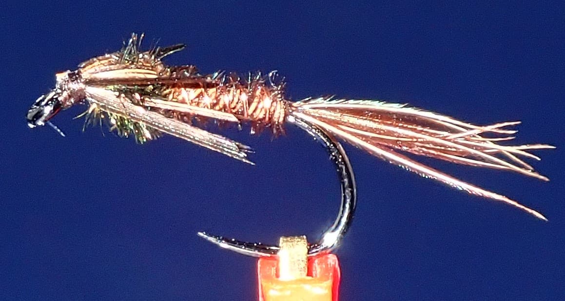 Fly pattern · report suggests “pheasant tail”Pheasant Tail NymphThe pilot page distinguishes the sparse original idea from the bulkier American form. Both use pheasant-tail fibers and copper wire, but bead heads, peacock-herl thoraxes, legs, flashbacks, jig hooks, and soft-hackle collars are variations that must be labeled.See photos & how to fish it ↗+ 2 more reviewed guides in the Fly Box
  Fly pattern · report suggests “Bugger”Woolly BuggerThe shared pattern language is a marabou tail, chenille or dubbed body, and palmered hackle. Bead heads, dumbbell eyes, flash, rubber tails, colors, and body materials materially change the tied variation and must be labeled.See photos & how to fish it ↗
 Fly family · report suggests “crawfish pattern”Crayfish and Crawfish PatternsCrayfish patterns differ in claw size, eye placement, shell profile, leg motion, weighting, hook orientation, and snag resistance. Rust, brown, olive, tan, and pale molting colors remain labeled choices rather than aliases for one recipe.See family guide ↗+ 2 more reviewed guides in the Fly Box
  Fly family · report suggests “Foam bug”Warmwater Surface Bug PatternsSurface bug wording can mean a foam attractor, spun-deer-hair bug, frog profile, spider-like panfish fly, or shaped head. Material alone does not establish whether the fly pops, slides, dives, or simply floats.See family guide ↗
 Fly family · report suggests “ant”Ant PatternsAnt patterns can be foam, fur-bodied, winged, or sunken. The narrow waist and paired body lobes matter more than one material recipe.See family guide ↗+ 2 more reviewed guides in the Fly Box
  Fly pattern · report suggests “Parachute Adams”Parachute AdamsThe upright light post and horizontal parachute hackle are the defining visual cues. The classic pilot example uses a gray-brown body and divided tail, but color and size variations should be labeled instead of treated as identical.See photos & how to fish it ↗Fly family · report suggests “soft hackle”Soft-Hackle Wet FliesA slim body and sparse webby feather collar define the family. Body material, tail, bead, and insect-specific color create different named patterns.See family guide ↗+ 1 more reviewed guide in the Fly Box
 Start with the Van Buren gauge and decide whether the day is really a float, a short access-stop session, or a full skip.
Treat Watercress and Big Spring as reach anchors, not as invitations to fish every mile between them without a plan.
Fish woody banks, shoal drop-offs, and current seams before overcovering open flat water.
If the river's color or pace takes clean drifts off the table, shorten the day instead of forcing distance.
Rules & closures
Open the agency page to confirm the exact river section, species, season, tackle rules, limits, and emergency closures.
Official links checkedWe checked the state source but did not find a clearly supported exception for this river. Check the official rules for the exact section you plan to fish.
This summary helps with trip planning. The linked agency rule is the one you must follow.
Updates from anglers
Recent observations from general areas of Current River. We review every update before it appears and never publish exact fishing spots, private access details, or photo locations.
You can still use the river plan above. Check back later for recent observations from other anglers.
Where this report comes from
Fishing guidance checked: Jun 2, 2026
Site check: Jul 14, 2026. We regularly test report links, live scores, flow and weather data, and page loading. The content date changes only when the fishing guidance or its sources change.
Common questions
Start with RiverReports and USGS 07067000, then compare the day's access and float plan against current Ozark National Scenic Riverways and Missouri guidance.
No. This page is intentionally scoped to the Van Buren lower-middle corridor, where float and warm-season mixed-fish planning matter more than upper-river trout expectations.
Watercress is the clearest named launch at Van Buren, with Big Spring and the mapped lower-river access network helping you shape longer days.