RiverReports preview · current series loading
Recent flow
RiverReports gauge
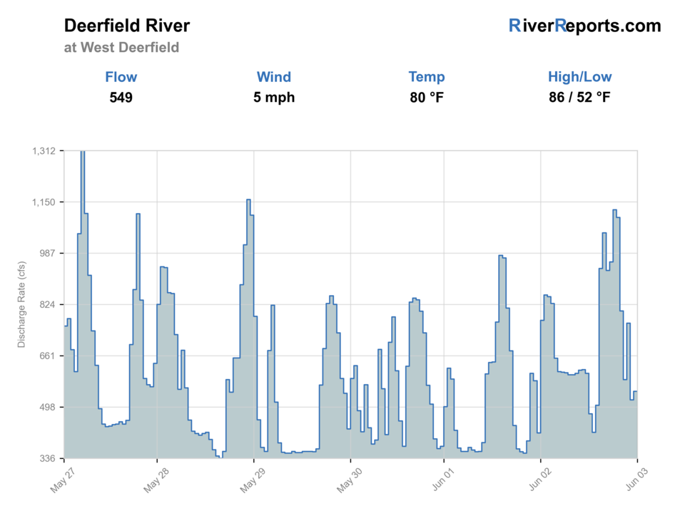
Showing the available RiverReports chart while the current structured flow series loads. Check the chart on RiverReports Opens in a new tab.
No single best way to fish. Wading, Bank fishing, and Floating have the same top score. Use current access, footing, weather, and local rules to choose.
Rating updatedRiver local time:
USGS shows 305 cfs. The flow has been stable over about 6 hours. USGS marks this reading provisional and may revise it. USGS records for this date (1905-2026, 88 readings) show a median near 648 cfs and the lower quartile near 371 cfs; today's flow is below normal for the date. This is below normal, so edge depth, temperature, and pressure matter.
NWS air forecast near
This is an air forecast, not a river-temperature reading. Check the water with a stream thermometer before fishing in hot weather.
RiverReports gauge
Showing the available RiverReports chart while the current structured flow series loads. Check the chart on RiverReports Opens in a new tab.
Sunny
The National Weather Service forecast is temporarily unavailable.
RiverReports gauge: Deerfield River near West Deerfield
Seasonal starting points, not a live hatch report. Match what you see on the water.
Also try hopper-dropper
Each fly name opens its matching Fly Box guide.
The lower Deerfield is strongest when moderate flows and cool weather let you fish the lower catch-and-release water or float selected downstream structure without forcing warm-season trout handling. It becomes a weaker trout bet once summer heat or pushy downstream flow removes the reason to stay here instead of fishing the upper river.
The best lower-river trout window for nymphing, streamer swings, and selective dry-fly water.
A sign to fish from the bank, shift upstream, or skip the float if the river loses shape.
Question the trout plan early because the lower river warms sooner than the Fife Brook reach.
A good sign for streamer or nymph coverage along deeper banks and tailouts.
Wading, Bank fishing, and Floating have the same top score. Use current access, footing, weather, and local rules to choose.
Wading is in play only where your chosen access has clear footing, legal entry, and no forced crossings.
Bank and edge fishing remains a practical low-commitment option if access is legal and footing is safe.
A float is in play where this report supports boat access and wind, releases, and shuttle logistics are manageable.
Is Deerfield River worth the trip today? Check flow, weather, hatches, access, and rules for the area at West Deerfield, Massachusetts before you go.
The West Deerfield area still benefits from the Deerfield's trout reputation, but it fishes differently from the coldest upper tailwater water. It is more sensitive to distance from the dam, heat, and whether your plan is really a short lower catch-and-release session or a broader downstream float day.
USGS shows 305 cfs. The flow has been stable over about 6 hours. USGS marks this reading provisional and may revise it. USGS records for this date (1905-2026, 88 readings) show a median near 648 cfs and the lower quartile near 371 cfs; today's flow is below normal for the date. This is below normal, so edge depth, temperature, and pressure matter.
Fall: A strong reset once cooler nights tighten temperatures and the river becomes easier to read again.
The current NWS air forecast is about 42F, and the next 24-hour high reaches about 63F. Sunny.
No active NWS alert was returned for this forecast point.
Skip when summer heat removes the trout edge, when access commitment is higher than the water quality justifies, or when the river is too pushy to wade cleanly.
Moderate readable flow that still lets you fish bank structure and deeper seams without turning the lower river into a pushy transport lane.
Skip when summer heat removes the trout edge, when access commitment is higher than the water quality justifies, or when the river is too pushy to wade cleanly.
Use the West Deerfield gauge to decide whether the lower river is earning the drive, then commit either to the lower catch-and-release section or to a float plan with a clear take-out.
If the lower Deerfield feels too warm or too broad for the day, move back to the upper Deerfield or switch to the Westfield or Millers instead of salvaging a weak trout plan.
Use these places as starting points. Open the access link below and check posted signs before you park or enter.
Use current Massachusetts freshwater rules and the Deerfield catch-and-release references before fishing. The lower special fishing rule stretch from Pelham Brook to Mohawk is artificial lures only and all fish must be released.
MassWildlife names it as a lower-section access point, but it requires a substantial walk to the river.
A more direct lower-section access point for the catch-and-release water.
MassWildlife notes many anglers reach the lower water by launching upstream and floating down.
Official agencies and primary river operators come first. Secondary tools are labeled so you know what carries the most weight.
Check what is allowed, where the rule applies, and whether the river is open.
Check the latest river reading and forecast before you leave.
Check public entry points, land rules, and seasonal access changes.
Check what is allowed, where the rule applies, and whether the river is open.
Open the current rules and check the river section, season, and special limits.
Open the current rules and check the river section, season, and special limits.
Check the latest river reading and forecast before you leave.
Open this page and check the latest safety advice before your trip.
Open this river reading to check the latest level, flow, and update time.
Open this river reading to check the latest level, flow, and update time.
Check public entry points, land rules, and seasonal access changes.
Open the land or access page, then check signs before you park or enter.
Open the land or access page, then check signs before you park or enter.
Open the land or access page, then check signs before you park or enter.
What was checked: This report uses official regulation, flow, weather, access, and public-land sources first, then adds practical planning guidance for fly anglers.
Live measurements and forecasts keep their provider timestamps. Rules, access, and trip guidance use the source-review date shown here. BlueStreamFly planning advice is editorial interpretation, not an agency notice.
First-hand experience: BlueStreamFly does not claim a first-hand visit or local field test for this report unless a real contributor is explicitly named and linked.
This page is built around the lower area and downstream gauge context, where summer heat, access logistics, and float planning matter more than they do right below Fife Brook.
Yes, but it is more condition-sensitive than the upper river. Cool weather and moderate flow matter more as you move farther from the dam.
Start by choosing between the Zoar Road and lower catch-and-release approach or a Mohawk Trail State Forest walk-in, then decide whether the day is really a wade or float plan.