Wade, bank, and floatPaused
Approach recommendations stay hidden until the hard stop clears.

Fly fishing report · West
A practical Warm Springs Creek page for anglers weighing Ketchum convenience against flow, heat, stocking timing, and the limited windows when this Big Wood tributary still fishes well.
Check flow & weatherRed Flag Warning issued August 2 at 1:04AM MDT until August 2 at 9:00PM MDT by NWS Pocatello ID
Red Flag Warning issued August 2 at 1:04AM MDT until August 2 at 9:00PM MDT by NWS Pocatello ID
The active safety or closure reason takes priority over wading, bank fishing, and floating guidance.
Approach recommendations stay hidden until the hard stop clears.
Check before you drive
Look at whether the river is rising or falling, then check wind, rain, and storms. These can change both safety and fishing.
Before you rely on this report
Conditions can change quickly. Check these dates before you decide to fish, and open the official source when safety or rules matter.
Medium confidence in the current score inputs.
6 sources are listed below for you to open.
3 public access records are listed. Private spots are never shown.
Source checked Jul 30, 2026
Plan your access
These are public parking, launch, trail, or recreation areas—not secret fishing spots. We never show an angler's private pins, notes, or photos here.
Area description
The City of Ketchum's 65-acre open-space preserve provides the clearest town-side public frontage and walking access context on the creek.
Town-side access is convenient, but convenience is not the same as dependable fishing quality. Let the gauge and temperature decide.
The preserve is valuable as a legal entry anchor, especially when you want a quick check before driving higher or choosing a different river.
Roadside access
Public road access through the drainage can be useful when the creek still has enough flow, but quality water is selective rather than continuous.
Town-side access is convenient, but convenience is not the same as dependable fishing quality. Let the gauge and temperature decide.
The preserve is valuable as a legal entry anchor, especially when you want a quick check before driving higher or choosing a different river.
Public land
The Sawtooth National Forest's Ketchum Ranger District covers the upstream drainage where cooler water and a more natural channel can matter most.
Town-side access is convenient, but convenience is not the same as dependable fishing quality. Let the gauge and temperature decide.
The preserve is valuable as a legal entry anchor, especially when you want a quick check before driving higher or choosing a different river.
How to fish it
Warm Springs Creek can offer a fun small-water option when spring runoff settles or when stocked summer fish still have enough cool moving water to hold. It loses value quickly once low clear flow, heavy visibility, and afternoon heat flatten the channel.
An active alert is in effect: Red Flag Warning issued August 2 at 1:04AM MDT until August 2 at 9:00PM MDT by NWS Pocatello ID. Check public safety sources before going.
No verified live public gauge is attached, so the page cannot make a strong real-time call.
Early summer: Usually the best blend of cover, cool water, and accessible town-adjacent fishing.
The NWS forecast is about 79F with Patchy Smoke.
Skip when the creek turns hot, shallow, and highly visible or when the best-looking water is too limited to handle fish responsibly.
Read the water
This page is strongest from late spring into early summer, then again during cooler fall mornings. Mid-summer can still produce quick stocked-fish sessions, but only if the creek remains cool enough and the water still has cover.
The best window for nymphs, attractor dries, and short dry-dropper drifts around depth changes and undercuts.
Fish early, cover likely holding water efficiently, and avoid stretching the session into warm afternoon hours.
Usually a sign to skip or limit the stop to a quick visual check before moving elsewhere.
A good reset when overnight temperatures restore some oxygen and the creek fishes smaller but cleaner.
Your trip plan
Moderate post-runoff or cooler-season levels that keep enough push over undercuts and pocket structure to hide fish and hold oxygen.
Skip when the creek turns hot, shallow, and highly visible or when the best-looking water is too limited to handle fish responsibly.
Check the Ketchum gauge, start at the preserve for a fast legal read, fish one short upper or middle reach if conditions still look good, and leave yourself time to pivot.
If Warm Springs is too warm or thin, move to Big Wood for more current or Silver Creek for a steadier coldwater plan.
Hatches & flies
 Fly pattern · report suggests “Zebra midge”Zebra MidgeLook for a very slim tapered thread body, evenly spaced contrasting wire rib, a small bead, and no tail or wing. The reviewed classic is black with silver wire and a silver bead. Red, olive, brown, glass-bead, jig-hook, resin-coated, or tailed forms must remain labeled variations rather than replacing the classic identity.See photos & how to fish it ↗
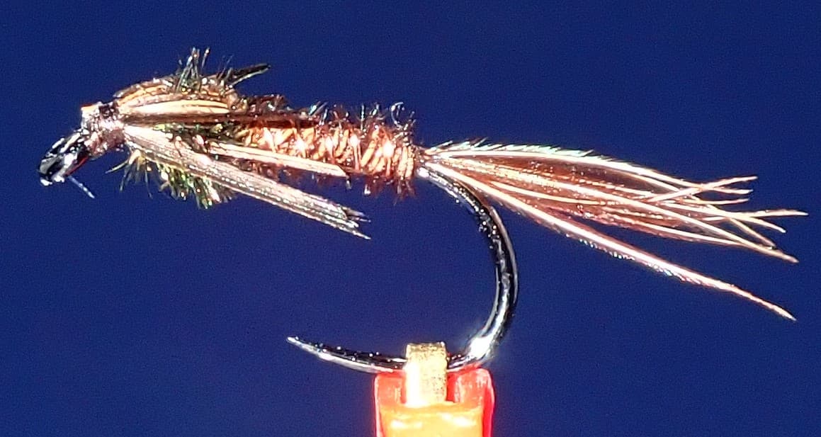 Fly pattern · report suggests “small pheasant tail”Pheasant Tail NymphThe pilot page distinguishes the sparse original idea from the bulkier American form. Both use pheasant-tail fibers and copper wire, but bead heads, peacock-herl thoraxes, legs, flashbacks, jig hooks, and soft-hackle collars are variations that must be labeled.See photos & how to fish it ↗+ 1 more reviewed guide in the Fly Box
  Fly pattern · report suggests “Elk hair caddis”Elk Hair CaddisLook for a tented elk- or deer-hair wing, clipped hair head, dubbed body, rib, and hackle palmered along the body. The body color should be labeled because tiers often match different natural caddis colors.See photos & how to fish it ↗
 Fly pattern · report suggests “PMD sparkle dun”Sparkle DunLook for an upright semicircular deer-hair wing, a low hackleless body and thorax, and a sparse trailing Zelon shuck. The shuck is the decisive difference from the separately photographed Comparaduns. In the Improved Sparkle Dun, the forward portion of the same Zelon bunch is bound along the shank and can add sparse flash behind the wing; body, shuck, size, and tone must be matched and labeled for the mayfly being imitated.See photos & how to fish it ↗+ 1 more reviewed guide in the Fly Box
  Fly family · report suggests “Foam ant”Ant PatternsAnt patterns can be foam, fur-bodied, winged, or sunken. The narrow waist and paired body lobes matter more than one material recipe.See family guide ↗
 Fly family · report suggests “beetle”Beetle PatternsBeetle flies range from simple foam shells to hair-bodied and sunken forms. A rounded back and compact profile distinguish the family from ants and hoppers.See family guide ↗+ 2 more reviewed guides in the Fly Box
  Fly family · report suggests “Parachute BWO”Blue-Winged Olive PatternsBWO describes a hatch group, not one fly. Nymph, emerger, dry, cripple, and spinner profiles must stay separate because they occupy different parts of the water column.See family guide ↗
 Fly pattern · report suggests “RS2”RS2Start with the beadless architecture: two dark-dun Microfibett tails separated behind a slim, tightly twisted and visibly segmented dubbed abdomen; a fuller thorax; and saddle-hackle web clipped into a short angled wing bud. Rim Chung's original-style form uses natural beaver dubbing and hackle web. CDC- or Antron-wing ties, beads, curved hooks, flash, and tailless Avatar-style flies must remain labeled variations.See photos & how to fish it ↗+ 1 more reviewed guide in the Fly Box
 Use the Ketchum gauge and temperature as the go or no-go test instead of assuming a town-adjacent creek is always fishable.
Fish the deepest bends, shaded banks, and obvious structure first because the useful habitat is concentrated.
Keep the session short and mobile. This creek gives up its answer quickly once you see how fish and water look.
If the preserve reach is busy or thin, move upstream only if the road corridor still shows colder, healthier water.
Rules & closures
Open the agency page to confirm the exact river section, species, season, tackle rules, limits, and emergency closures.
Official links checkedWe checked the state source but did not find a clearly supported exception for this river. Check the official rules for the exact section you plan to fish.
This summary helps with trip planning. The linked agency rule is the one you must follow.
Updates from anglers
Recent observations from general areas of Warm Springs Creek. We review every update before it appears and never publish exact fishing spots, private access details, or photo locations.
You can still use the river plan above. Check back later for recent observations from other anglers.
Where this report comes from
Fishing guidance checked: Jul 6, 2026
Site check: Jul 14, 2026. We regularly test report links, live scores, flow and weather data, and page loading. The content date changes only when the fishing guidance or its sources change.
Common questions
Check RiverReports and USGS 13137000 near Ketchum first, then decide whether water temperature and visible cover still justify a trout session.
Not for an automated live score. This page links the best available flow source where one exists, but the fishability answer stays conservative until a current readable gauge is available for the exact reach. Check the linked source, weather, clarity, access, and recent rain before going.
Start with the Warm Springs Preserve for the fastest legal check, then move up the drainage only if the creek still shows enough current and cover.