RiverReports preview · current series loading
Recent flow
RiverReports gauge
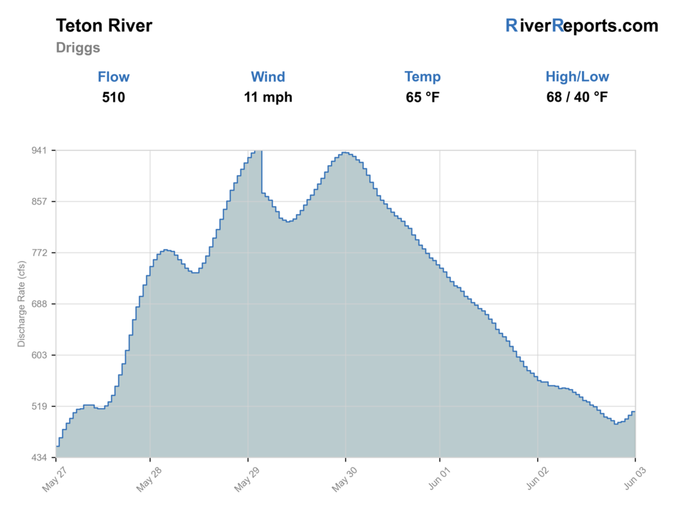
Showing the available RiverReports chart while the current structured flow series loads. Check the chart on RiverReports Opens in a new tab.
Fish from the bank. Bank and edge fishing remains a practical low-commitment option if access is legal and footing is safe.
Rating updatedRiver local time:
A Flood Watch is active near this forecast point, so the score is capped until runoff, clarity, crossings, and road access are checked. NWS alert: Flood Watch issued October 11 at 7:26PM MDT until October 12 at 6:00PM MDT by NWS Pocatello ID.
NWS air forecast near
This is an air forecast, not a river-temperature reading. Check the water with a stream thermometer before fishing in hot weather.
RiverReports gauge
Showing the available RiverReports chart while the current structured flow series loads. Check the chart on RiverReports Opens in a new tab.
Light Rain Likely
The National Weather Service forecast is temporarily unavailable.
RiverReports gauge: Teton River above South Leigh Creek near Driggs
Seasonal starting points, not a live hatch report. Match what you see on the water.
Each fly name opens its matching Fly Box guide.
This route is strongest for anglers who want to chase upper-valley dry-dropper and meadow-bank windows in late spring, early summer, and cool-weather fall periods rather than fish the whole drainage.
The best case for dry-dropper, bank nymphing, and moving methodically between named accesses.
Fish finer tippet, smaller bugs, and the first or last light rather than the high sun window.
Expect fewer clean drifts and more value from short focused sessions instead of all-day mileage.
Downsize the plan or postpone it because upper-Teton drift control disappears quickly.
These scores compare the risks of wading, bank fishing, and floating.
Wading is in play only where your chosen access has clear footing, legal entry, and no forced crossings.
Bank and edge fishing remains a practical low-commitment option if access is legal and footing is safe.
A float is in play where this report supports boat access and wind, releases, and shuttle logistics are manageable.
Is Teton River worth the trip today? Check flow, weather, hatches, access, and rules for Driggs, Idaho before you go.
The upper Teton around Driggs is at its best when the South Leigh gauge holds enough water to push clean seams along grassy cutbanks and keep side channels meaningful. It becomes technical, shallow, and less forgiving once heat, weeds, or valley wind start removing that structure.
A Flood Watch is active near this forecast point, so the score is capped until runoff, clarity, crossings, and road access are checked. NWS alert: Flood Watch issued October 11 at 7:26PM MDT until October 12 at 6:00PM MDT by NWS Pocatello ID.
Bank / edge: Bank and edge fishing remains a practical low-commitment option if access is legal and footing is safe.
USGS shows 305 cfs. The flow has been rising about 21% over about 6 hours. USGS marks this reading provisional and may revise it. USGS records for this date (1962-2026, 65 readings) show a typical middle range of 205 cfs to 353 cfs. Flow is within the typical range for this date, so weather, temperature, and access become the next checks.
Fall: Excellent when overnight lows cool the meadow water and the river regains a crisp technical feel.
The current NWS air forecast is about 40F, and the next 24-hour high reaches about 54F. Light Rain Likely.
Moderate upper-valley flows that still hold clean undercut seams and keep side channels from turning into disconnected weed lanes.
Skip when wind makes casting feel random, when low water flattens the banks, or when heat pushes the upper meadow into a short-window fishery.
Start with Bates or Rainey, fish hard through the coolest part of the day, and keep the full-river or Henry's Fork page ready as a backup if the meadow looks thin.
If the Driggs reach looks too low or too windy, slide to the full-river Teton page, Henry's Fork, or the South Fork of the Snake after checking conditions there.
Use these places as starting points. Open the access link below and check posted signs before you park or enter.
Use the Idaho Fish and Game Teton River planner for current rules. The main stem allows no harvest of cutthroat trout and unlimited harvest of rainbow trout or trout hybrids, while nearby smaller streams follow separate seasonal and June-closure restrictions.
Official Idaho Fish and Game access about 4 miles west of Driggs and one of the best upper-valley anchors.
Listed in the Upper Snake access guide as a two-sided Teton River access roughly 12 miles northwest of Driggs.
Guide-listed upper-river access that broadens the reach options when one bridge section feels too crowded or too slow.
Official agencies and primary river operators come first. Secondary tools are labeled so you know what carries the most weight.
Check what is allowed, where the rule applies, and whether the river is open.
Check the latest river reading and forecast before you leave.
Check public entry points, land rules, and seasonal access changes.
Use these links for stocking, safety, and other local details.
Check what is allowed, where the rule applies, and whether the river is open.
Open the current rules and check the river section, season, and special limits.
Check the latest river reading and forecast before you leave.
Open this page and check the latest safety advice before your trip.
Open this river reading to check the latest level, flow, and update time.
Open this river reading to check the latest level, flow, and update time.
Check public entry points, land rules, and seasonal access changes.
Open the land or access page, then check signs before you park or enter.
Open the land or access page, then check signs before you park or enter.
Use these links for stocking, safety, and other local details.
Open this page for more river information and check when it was last updated.
What was checked: This report uses official regulation, flow, weather, access, and public-land sources first, then adds practical planning guidance for fly anglers.
Live measurements and forecasts keep their provider timestamps. Rules, access, and trip guidance use the source-review date shown here. BlueStreamFly planning advice is editorial interpretation, not an agency notice.
First-hand experience: BlueStreamFly does not claim a first-hand visit or local field test for this report unless a real contributor is explicitly named and linked.
Use RiverReports and USGS 13052200 above South Leigh Creek near Driggs because that gauge best matches the upper-valley meadow water on this page.
Usually wading first. Float only when flows, weeds, and wind all line up well enough to make the upper meadow channel efficient.
Leave it alone when the South Leigh gauge is low enough that the river loses shape, when the afternoon gets too warm, or when valley wind ruins presentation control.


