RiverReports preview · current series loading
Recent flow
RiverReports gauge
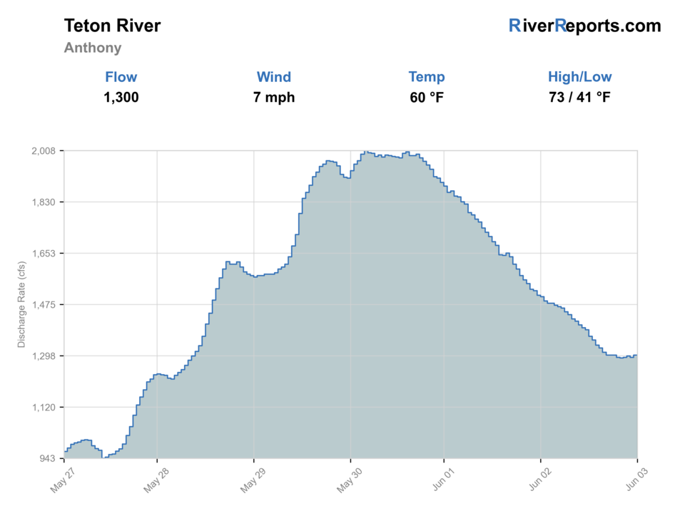
Showing the available RiverReports chart while the current structured flow series loads. Check the chart on RiverReports Opens in a new tab.
No access method is recommended today. Review the live conditions below before choosing another river or day.
Rating updatedRiver local time:
An active alert is in effect: Flash Flood Watch issued October 22 at 1:51AM MDT until October 23 at 6:00PM MDT by NWS Pocatello ID. Check public safety sources before going.
Flash Flood Watch issued October 22 at 1:51AM MDT until October 23 at 6:00PM MDT by NWS Pocatello ID
NWS air forecast near
This is an air forecast, not a river-temperature reading. Check the water with a stream thermometer before fishing in hot weather.
RiverReports gauge
Showing the available RiverReports chart while the current structured flow series loads. Check the chart on RiverReports Opens in a new tab.
Mostly Sunny
The National Weather Service forecast is temporarily unavailable.
RiverReports gauge: Teton River near St. Anthony
Seasonal starting points, not a live hatch report. Match what you see on the water.
Also try small dropper nymph
Each fly name opens its matching Fly Box guide.
This page fishes best as a shoulder-to-summer timing river: spring after runoff settles, early summer before weeds and irrigation shape the valley too hard, and cooler fall windows when wind and water temperatures cooperate.
Best for float-style coverage, meadow-bank nymphing, and dry-dropper fishing where side channels still have life.
Fish early, fish lighter, and focus on undercut banks or deeper meadow bends instead of broad shallow glides.
Expect reduced dry-fly control and tougher rowing or wading visibility. Simplify the day around protected bends.
Carry a thermometer and end the trip when the river stops feeling like cutthroat water.
No access method is recommended in today's conditions. Review the live river and weather checks before making another plan.
Not recommended today. Recheck the river, weather, and access before planning another trip.
Not recommended today. Recheck the river, weather, and access before planning another trip.
Not recommended today. Recheck the river, weather, and access before planning another trip.
Is Teton River worth the trip today? Check flow, weather, hatches, access, and rules for Idaho before you go.
The main-stem Teton is most useful when upper-valley and lower-valley flows agree enough to keep side channels connected, cutbanks defined, and grass-bank bankside seams moving cleanly. It loses value fast when heat, weeds, and low late-summer volume flatten the meadow water or when wind turns the open valley into a difficult drift.
An active alert is in effect: Flash Flood Watch issued October 22 at 1:51AM MDT until October 23 at 6:00PM MDT by NWS Pocatello ID. Check public safety sources before going.
USGS shows 397 cfs. The flow has been stable over about 6 hours. USGS marks this reading provisional and may revise it. USGS records for this date (1891-2026, 104 readings) show a median near 504 cfs and a low-water marker near 403 cfs; today's flow is unusually low for the date. Low water can make fish spooky, warm, pressured, or concentrated; check temperature and handling risk.
Fall: A strong reset when cooler nights bring better water temperatures and steadier meadow fishing windows.
The current NWS air forecast is about 67F, and the next 24-hour high reaches about 69F. Mostly Sunny.
Skip when hot weather, weeds, or low late-summer water flatten the river, or when wind is strong enough that you cannot control a boat or a long leader.
Stable moderate valley flows that keep side channels connected, banks defined, and enough water over meadow shelves to drift a dry-dropper or nymph rig cleanly.
Skip when hot weather, weeds, or low late-summer water flatten the river, or when wind is strong enough that you cannot control a boat or a long leader.
Compare the St. Anthony and Driggs gauges, choose one reach family for the day, launch from a named bridge access, and plan to quit before the river warms out.
If the Teton turns too windy, weedy, or warm, pivot to Henry's Fork, the South Fork of the Snake, or an upper-valley half day on the Driggs reach after checking current conditions.
Use these places as starting points. Open the access link below and check posted signs before you park or enter.
Idaho Fish and Game's current Teton River rules allow no harvest of cutthroat trout and no limit on rainbow trout or trout hybrids on the main stem. Smaller streams follow separate restrictions, including a June 1 through June 30 fishing closure.
Official Idaho Fish and Game access roughly 4 miles west of Driggs on the east bank of the Teton River.
Official Idaho Fish and Game bridge access in Teton County with a gravel boat ramp and day-use rules.
Listed in Idaho Fish and Game's Upper Snake access guide and useful for longer upper-valley river days.
The clearest official lower-river access anchor near the St. Anthony side of the basin.
Official agencies and primary river operators come first. Secondary tools are labeled so you know what carries the most weight.
Check what is allowed, where the rule applies, and whether the river is open.
Check the latest river reading and forecast before you leave.
Check public entry points, land rules, and seasonal access changes.
Use these links for stocking, safety, and other local details.
Check what is allowed, where the rule applies, and whether the river is open.
Open the current rules and check the river section, season, and special limits.
Check the latest river reading and forecast before you leave.
Open this page and check the latest safety advice before your trip.
Open this river reading to check the latest level, flow, and update time.
Open this river reading to check the latest level, flow, and update time.
Open this river reading to check the latest level, flow, and update time.
Check public entry points, land rules, and seasonal access changes.
Open the land or access page, then check signs before you park or enter.
Open the land or access page, then check signs before you park or enter.
Open the land or access page, then check signs before you park or enter.
Open the land or access page, then check signs before you park or enter.
Use these links for stocking, safety, and other local details.
Open this page for more river information and check when it was last updated.
What was checked: This report uses official regulation, flow, weather, access, and public-land sources first, then adds practical planning guidance for fly anglers.
Live measurements and forecasts keep their provider timestamps. Rules, access, and trip guidance use the source-review date shown here. BlueStreamFly planning advice is editorial interpretation, not an agency notice.
First-hand experience: BlueStreamFly does not claim a first-hand visit or local field test for this report unless a real contributor is explicitly named and linked.
For this full-river page, start with RiverReports and USGS 13055000 near St. Anthony, then compare it to USGS 13052200 near Driggs if you are choosing between upper and lower valley water.
No. Current Idaho Fish and Game rules say there is no harvest of cutthroat trout on the main-stem Teton River.
Skip when the valley is running hot, low, or weedy enough to flatten the trout water, or when all-day wind will keep you from fishing the meadow seams cleanly.