Wade, bank, and floatLimited data
Use the live sources and what you see at the river before choosing an approach.
Fly fishing report · West
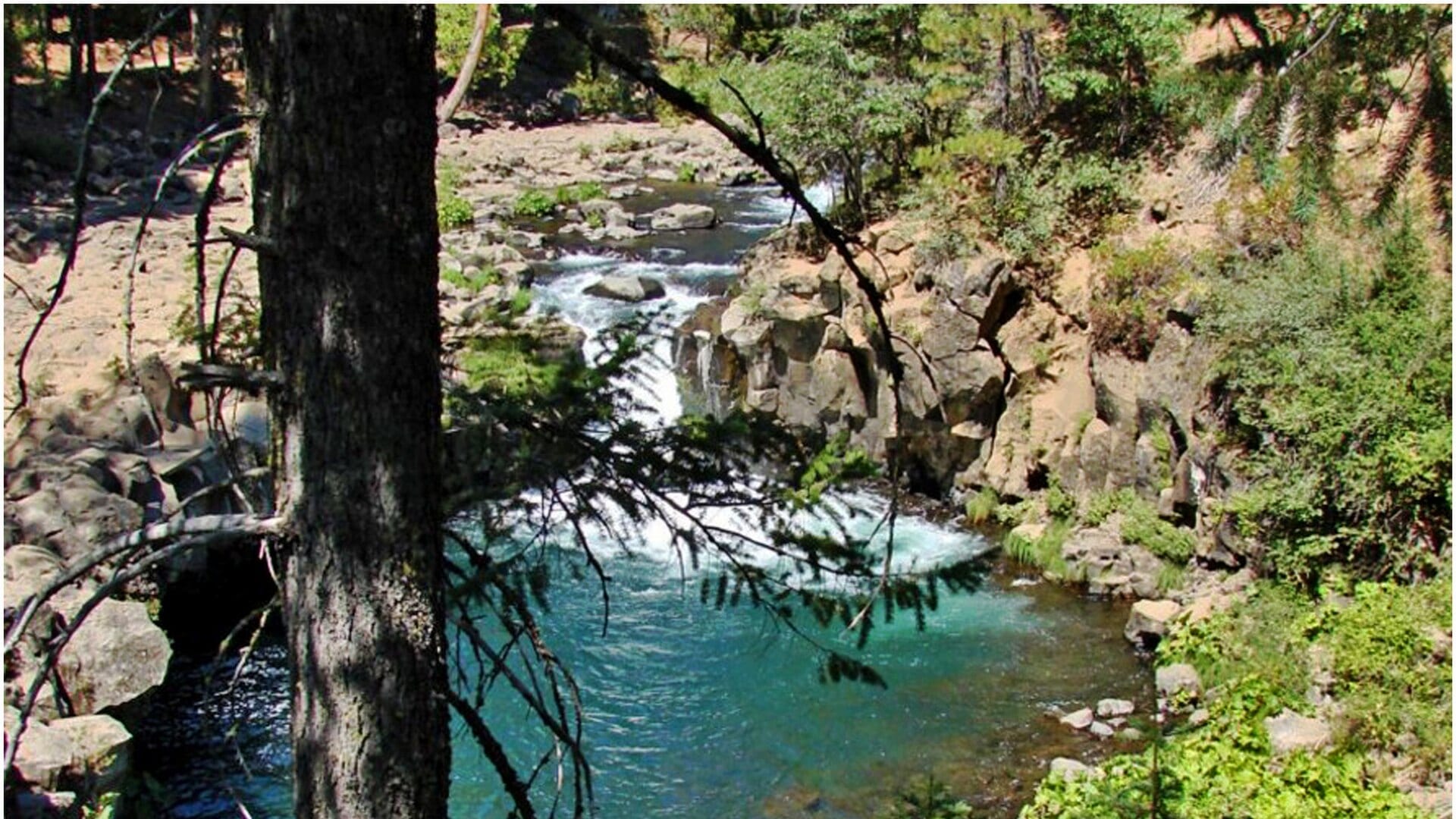
A lower McCloud report for Ah-Di-Na and preserve planning, canyon access, flow changes below McCloud Dam, barbless tactics, hatches, and source checks.
Check flow & weatherThis river does not have a reliable live gauge attached. Check the weather, recent rain, local reports, and the water when you arrive.
There is not enough reliable current information to recommend wading, bank fishing, or floating.
Use the live sources and what you see at the river before choosing an approach.
Check before you drive
Look at whether the river is rising or falling, then check wind, rain, and storms. These can change both safety and fishing.
Before you rely on this report
Conditions can change quickly. Check these dates before you decide to fish, and open the official source when safety or rules matter.
Medium confidence in the current score inputs.
9 sources are listed below for you to open.
4 public access records are listed. Private spots are never shown.
Source checked Jul 30, 2026
Plan your access
These are public parking, launch, trail, or recreation areas—not secret fishing spots. We never show an angler's private pins, notes, or photos here.
Roadside access
A key lower-river planning point with rough-road access and downstream private-water cautions.
USFS notes private water below Ah-Di-Na; do not continue downstream without knowing the boundary.
The preserve is not casual open access. Follow current TNC rules if visiting.
Roadside access
USFS guidance is important for rules, access, road, and flow-related cautions.
USFS notes private water below Ah-Di-Na; do not continue downstream without knowing the boundary.
The preserve is not casual open access. Follow current TNC rules if visiting.
Area description
Managed-use water with sign-in, season, and angler-limit requirements. Check TNC before going.
USFS notes private water below Ah-Di-Na; do not continue downstream without knowing the boundary.
The preserve is not casual open access. Follow current TNC rules if visiting.
Area description
Different access and fishery character; do not blend upper-river redband context into every lower-river plan.
USFS notes private water below Ah-Di-Na; do not continue downstream without knowing the boundary.
The preserve is not casual open access. Follow current TNC rules if visiting.
How to fish it
The McCloud is a famous trout river, but lower-river access is not simple. Check USFS conditions, CDFW regulations, private boundaries, preserve rules, and flow before driving the road to Ah-Di-Na or planning below it.
No verified live public gauge is attached, so the page cannot make a strong real-time call.
Early summer: Caddis, golden stones, PMDs, and pocket-water nymphing can be strong before heat and crowds build.
The NWS forecast is about 78F with Clear.
No active NWS alert was returned for this forecast point.
Skip the trip when road access is closed, when spill or release notices make the lower canyon pushy, when the preserve is outside its open season, when hot weather turns the hike into the hardest part of the day, or when your plan depends on water below the legal public access corridor.
Read the water
Fish the McCloud as technical canyon water: verify the legal reach, move carefully, and match the presentation to shade, flow, and hatch timing. It is not a casual roadside river once you are below the easy upper access.
Use stealth, long leaders, small nymphs, and careful dry-fly drifts in shaded water.
Nymph pocket water, swing soft hackles, and watch for caddis or mayfly activity.
Stay out of unsafe crossings and focus on edges only if conditions are clearly manageable.
The canyon can stay cooler than valley water, but still check temperature and fish handling.
Your trip plan
Use the McCloud gauge as general context, then verify whether the Forest Service or local notices mention spill or release changes below the dam. Normal clear canyon flows are the best fit; if spill-driven levels are rising toward the heavy-flow range, the smart move is usually to stay out of crossings and either fish only obvious edges or wait it out.
Skip the trip when road access is closed, when spill or release notices make the lower canyon pushy, when the preserve is outside its open season, when hot weather turns the hike into the hardest part of the day, or when your plan depends on water below the legal public access corridor.
Choose the access before the hatch: confirm the Forest Service lower-river status, decide whether Ah-Di-Na or the preserve is your walk-in base, then fish a shorter stretch thoroughly instead of spending half the day driving rough roads and second-guessing property lines.
If the lower McCloud is closed, crowded, or running too hard, pivot to Hat Creek for another technical northern California trout day or to the upper Sacramento if you need a road-access trout plan with more public pullouts.
Hatches & flies
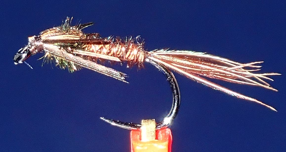 Fly pattern · report suggests “Pheasant tail”Pheasant Tail NymphThe pilot page distinguishes the sparse original idea from the bulkier American form. Both use pheasant-tail fibers and copper wire, but bead heads, peacock-herl thoraxes, legs, flashbacks, jig hooks, and soft-hackle collars are variations that must be labeled.See photos & how to fish it ↗
 Fly family · report suggests “BWO”Blue-Winged Olive PatternsBWO describes a hatch group, not one fly. Nymph, emerger, dry, cripple, and spinner profiles must stay separate because they occupy different parts of the water column.See family guide ↗+ 3 more reviewed guides in the Fly Box
  Fly family · report suggests “Golden stone”Golden Stonefly PatternsGolden stonefly wording may describe the insect, nymph, or dry. Nymph tones can range from yellow-gold to amber and brown, while adult patterns require a distinct winged surface silhouette.See family guide ↗
 Fly family · report suggests “PMD dry”Pale Morning Dun PatternsPMD names an insect group, not one fly. Pale nymphs, trailing-shuck emergers, upright or low-riding duns, cripples, and spent-wing spinners stay visibly separate.See family guide ↗+ 2 more reviewed guides in the Fly Box
  Fly family · report suggests “Caddis dry”Caddis Patterns by StageCaddis is not one fly. Larvae live below, pupae and emergers rise through the column, tent-wing adults ride or move on top, and spent forms create other silhouettes.See family guide ↗
 Fly family · report suggests “ant”Ant PatternsAnt patterns can be foam, fur-bodied, winged, or sunken. The narrow waist and paired body lobes matter more than one material recipe.See family guide ↗+ 3 more reviewed guides in the Fly Box Fly family · report suggests “BWO emerger”Blue-Winged Olive PatternsBWO describes a hatch group, not one fly. Nymph, emerger, dry, cripple, and spinner profiles must stay separate because they occupy different parts of the water column.See family guide ↗
 Fly family · report suggests “October caddis”October Caddis PatternsOctober Caddis names a hatch group. Amber or orange pupae, soft-hackle or wet forms, and large tent-wing adults fish at different levels.See family guide ↗+ 2 more reviewed guides in the Fly Box
 Read the USFS page before driving because flow and road notes can change.
Confirm whether the reach is public, private, or managed preserve water.
Fish pockets from downstream and keep false casting low in tight canyon cover.
Use enough weight to reach bottom quickly in fast slots, then shorten drifts.
Watch for evening caddis and low-light streamer chances.
Rules & closures
Open the agency page to confirm the exact river section, species, season, tackle rules, limits, and emergency closures.
Official links checkedWe checked the state source but did not find a clearly supported exception for this river. Check the official rules for the exact section you plan to fish.
This summary helps with trip planning. The linked agency rule is the one you must follow.
Updates from anglers
Recent observations from general areas of McCloud River. We review every update before it appears and never publish exact fishing spots, private access details, or photo locations.
You can still use the river plan above. Check back later for recent observations from other anglers.
Where this report comes from
Fishing guidance checked: Jul 6, 2026
Site check: Jul 14, 2026. We regularly test report links, live scores, flow and weather data, and page loading. The content date changes only when the fishing guidance or its sources change.
Common questions
It focuses on the lower McCloud below McCloud Dam, especially the Ah-Di-Na and managed-preserve planning context.
No. Roads, private water, managed preserve rules, and canyon conditions make access planning essential.
Not for an automated live score. This page links the best available flow source where one exists, but the fishability answer stays conservative until a current readable gauge is available for the exact reach. Check the linked source, weather, clarity, access, and recent rain before going.
Only where access is legal. USFS warns that water below Ah-Di-Na includes private property and managed access.