Wade · Best fit74/100
Wading is in play only where your chosen access has clear footing, legal entry, and no forced crossings.
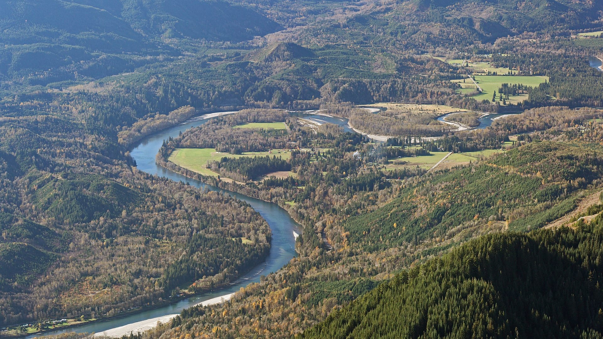
Fly fishing report · Pacific Northwest
A Skagit report for Concrete, Rockport, and Marblemount planning, with flow checks, salmon and steelhead guardrails, access, weather, and fly tactics.
Check flow & weatherCurrent USGS flow is 7,170 cfs and has been stable for about 6 hours. Today's flow is unusually low for this date and below the usual low-water marker near 8,100 cfs. Low water can make fish spooky, warm, pressured, or concentrated; check temperature and handling risk.
Compare wading, bank fishing, and floating before choosing how you will fish.
Wading is in play only where your chosen access has clear footing, legal entry, and no forced crossings.
Bank and edge fishing remains a practical low-commitment option if access is legal and footing is safe.
A float is in play where this report supports boat access and wind, releases, and shuttle logistics are manageable.
Check before you drive
Look at whether the river is rising or falling, then check wind, rain, and storms. These can change both safety and fishing.
Before you rely on this report
Conditions can change quickly. Check these dates before you decide to fish, and open the official source when safety or rules matter.
High confidence in the current score inputs.
8 sources are listed below for you to open.
3 public access records are listed. Private spots are never shown.
Source checked Jul 30, 2026
Plan your access
These are public parking, launch, trail, or recreation areas—not secret fishing spots. We never show an angler's private pins, notes, or photos here.
Public land
A verified public recreation anchor for middle Skagit planning.
Do not treat lower Skagit conditions as the same as Concrete or Marblemount.
Boat launches, parks, and gravel bars may have seasonal or weather-related limits.
Roadside access
Upper-river towns for big-river access, weather, and road checks.
Do not treat lower Skagit conditions as the same as Concrete or Marblemount.
Boat launches, parks, and gravel bars may have seasonal or weather-related limits.
Area description
Best live flow reference for this scoped report.
Do not treat lower Skagit conditions as the same as Concrete or Marblemount.
Boat launches, parks, and gravel bars may have seasonal or weather-related limits.
How to fish it
The Skagit is large, beautiful, and heavily regulated. Use the Concrete gauge for upper and middle river flow, then verify WDFW emergency rules for salmon, steelhead, trout, and gamefish before choosing a plan.
USGS shows 7,170 cfs with a stable over about 6 hours trend. Today's flow is unusually low for this date and below the usual low-water marker near 8,100 cfs. Low water can make fish spooky, warm, pressured, or concentrated; check temperature and handling risk.
Summer: Upper-river access and trout or char context depend on rules and temperature.
The NWS forecast is about 64F with Mostly Sunny.
No active NWS alert was returned for this forecast point.
Skip the Skagit when WDFW rules do not clearly support the target species, when high water erases safe bars, when protected fish are concentrated, or when the day depends on lower-valley assumptions that do not match Concrete or Marblemount conditions.
Read the water
The Skagit is most useful when flow is stable enough for safe bank or boat planning and WDFW rules clearly support the species. If rules are unclear, do not fish it on assumptions.
Fish softer seams, side channels, and bar edges where legal.
Use boat ramps and observation points; avoid wading heavy current.
Often the best time to evaluate clarity and safe access.
Long leaders, smaller flies, and careful approach become more important.
Your trip plan
Use USGS 12194000 near Concrete as the core upper and middle Skagit trend. Stable or easing flows with workable clarity are the best fit; high flows, cold heavy current, or unclear species rules should shorten or cancel the trip.
Skip the Skagit when WDFW rules do not clearly support the target species, when high water erases safe bars, when protected fish are concentrated, or when the day depends on lower-valley assumptions that do not match Concrete or Marblemount conditions.
Choose one anchor before fishing: Rasar State Park for a public middle-river base, Rockport or Marblemount for upper-river context, or the Concrete gauge corridor when flow and weather are the main decision.
If Skagit flow, clarity, or rules do not line up, compare the Sauk for a tributary plan only if legal, the Skykomish for another west-side rules-first river, or the Yakima for a more predictable trout-centered day.
Hatches & flies
 Fly family · report suggests “BWO emerger”Blue-Winged Olive PatternsBWO describes a hatch group, not one fly. Nymph, emerger, dry, cripple, and spinner profiles must stay separate because they occupy different parts of the water column.See family guide ↗
 Fly pattern · report suggests “zebra midge”Zebra MidgeLook for a very slim tapered thread body, evenly spaced contrasting wire rib, a small bead, and no tail or wing. The reviewed classic is black with silver wire and a silver bead. Red, olive, brown, glass-bead, jig-hook, resin-coated, or tailed forms must remain labeled variations rather than replacing the classic identity.See photos & how to fish it ↗+ 3 more reviewed guides in the Fly Box
  Fly pattern · report suggests “Elk hair caddis”Elk Hair CaddisLook for a tented elk- or deer-hair wing, clipped hair head, dubbed body, rib, and hackle palmered along the body. The body color should be labeled because tiers often match different natural caddis colors.See photos & how to fish it ↗
 Fly family · report suggests “PMD emerger”Pale Morning Dun PatternsPMD names an insect group, not one fly. Pale nymphs, trailing-shuck emergers, upright or low-riding duns, cripples, and spent-wing spinners stay visibly separate.See family guide ↗+ 3 more reviewed guides in the Fly Box
  Fly family · report suggests “Foam hopper”Grasshopper PatternsHopper patterns share a substantial body and long rear-leg impression, but foam, deer hair, wing construction, and waterline differ widely among named patterns.See family guide ↗
 Fly family · report suggests “ant”Ant PatternsAnt patterns can be foam, fur-bodied, winged, or sunken. The narrow waist and paired body lobes matter more than one material recipe.See family guide ↗+ 4 more reviewed guides in the Fly Box
  Fly family · report suggests “October caddis”October Caddis PatternsOctober Caddis names a hatch group. Amber or orange pupae, soft-hackle or wet forms, and large tent-wing adults fish at different levels.See family guide ↗Fly family · report suggests “BWO emerger”Blue-Winged Olive PatternsBWO describes a hatch group, not one fly. Nymph, emerger, dry, cripple, and spinner profiles must stay separate because they occupy different parts of the water column.See family guide ↗+ 3 more reviewed guides in the Fly Box
 Pick a legal target before choosing a fly.
On big gravel bars, fish the first safe travel lane instead of wading toward the middle.
Use swung flies, streamers, or nymphs only where methods are legal for the target species.
Avoid side channels with spawning fish or exposed redds.
Use the Concrete hydrograph to decide whether your return route may flood.
Rules & closures
Open the agency page to confirm the exact river section, species, season, tackle rules, limits, and emergency closures.
Official links checkedEmergency order
This summary helps with trip planning. The linked agency rule is the one you must follow.
Updates from anglers
Recent observations from general areas of Skagit River. We review every update before it appears and never publish exact fishing spots, private access details, or photo locations.
You can still use the river plan above. Check back later for recent observations from other anglers.
Where this report comes from
Fishing guidance checked: Jun 1, 2026
Site check: Jul 14, 2026. We regularly test report links, live scores, flow and weather data, and page loading. The content date changes only when the fishing guidance or its sources change.
Common questions
WDFW emergency rules, Concrete flow, salmon or steelhead status, park access, weather, and clarity
Use USGS 12194000 Skagit River near Concrete for the upper and middle river report.
Start with Rasar State Park, Rockport, Marblemount, and other legal public access points after checking WDFW rules.
Only on safe margins and gravel edges at suitable flows. This is a large cold river where crossing is usually a poor plan.