RiverReports preview · current series loading
Recent flow
RiverReports gauge
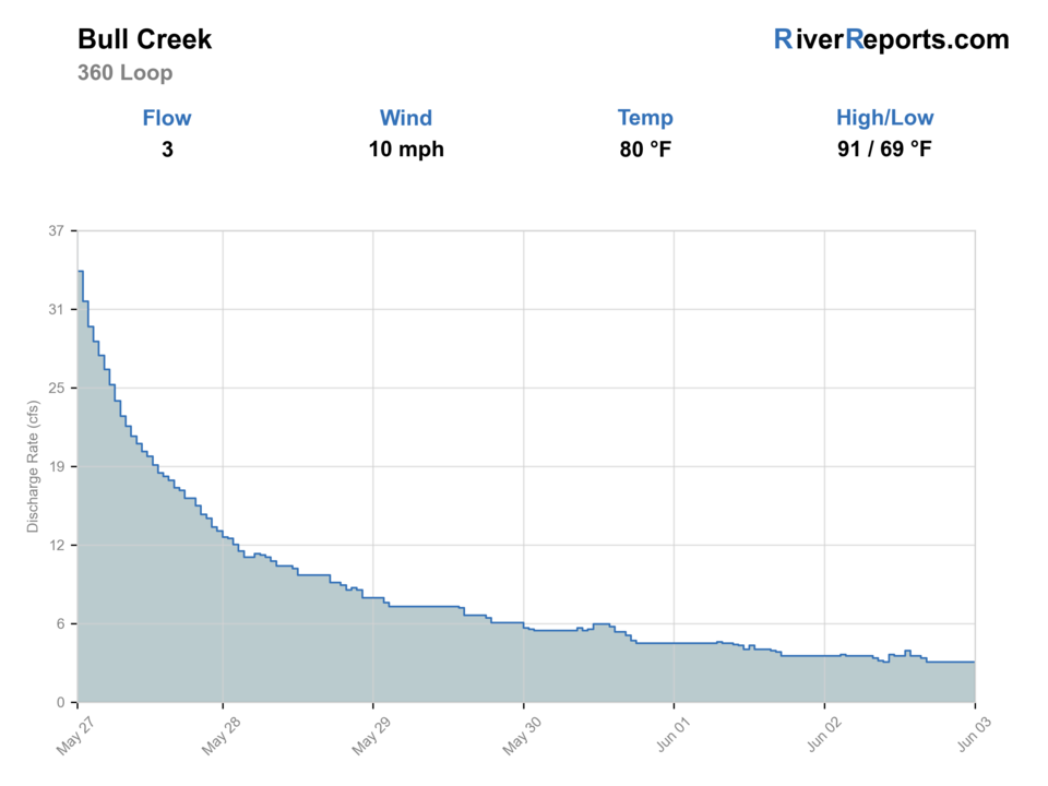
Showing the available RiverReports chart while the current structured flow series loads. Check the chart on RiverReports Opens in a new tab.
No single best way to fish. Wading, Bank fishing, and Floating have the same top score. Use current access, footing, weather, and local rules to choose.
Rating updatedRiver local time:
USGS shows 0 cfs. Recent readings do not show a clear trend. USGS marks this reading provisional and may revise it. USGS records for this date (1979-2026, 48 readings) show a median near 3 cfs and a low-water marker near 0 cfs; today's flow is unusually low for the date. Low water can make fish spooky, warm, pressured, or concentrated; check temperature and handling risk.
NWS air forecast near
This is an air forecast, not a river-temperature reading.
RiverReports gauge
Showing the available RiverReports chart while the current structured flow series loads. Check the chart on RiverReports Opens in a new tab.
Sunny
The National Weather Service forecast is temporarily unavailable.
RiverReports gauge: Bull Ck at Loop 360 nr Austin, TX
Seasonal starting points, not a live hatch report. Match what you see on the water.
Also try small craw pattern
Also try small crayfish fly
Each fly name opens its matching Fly Box guide.
Bull Creek fishes best as a quick, flexible Austin option after stable weather, when the creek has enough push to cover pocket water but not so much color or current that the limestone shelves become the whole story. If thunderstorms are in play, trailheads are crowded, or the gauge is jumping, switch to a larger river or a non-fishing greenbelt day.
The best Bull Creek window for short casts, clear pocket-water reads, and careful wading on limestone shelves.
Fish early, downsize flies, and stay off the skyline because creek fish get wary fast in skinny Austin water.
A strong skip signal because Bull Creek's small watershed can lose clarity and footing margin quickly.
Treat heavy swimmer, hiker, and dog traffic as a condition problem, not just a social annoyance, and shorten the day or move on.
Wading, Bank fishing, and Floating have the same top score. Use current access, footing, weather, and local rules to choose.
Wading is in play only where your chosen access has clear footing, legal entry, and no forced crossings.
Bank and edge fishing remains a practical low-commitment option if access is legal and footing is safe.
A float is in play where this report supports boat access and wind, releases, and shuttle logistics are manageable.
Is Bull Creek worth the trip today? Check flow, weather, hatches, access, and rules for Texas before you go.
Bull Creek is strongest when the USGS Loop 360 gauge is stable enough to read pocket water and the public city-park entries are your entire plan. Start with RiverReports and USGS 08154700, fish the creek like a warmwater limestone stream with modest fish size and heavy recreation pressure, and skip the day when flash-rise risk, muddy water, or packed trailheads remove the small-stream advantage.
USGS shows 0 cfs. Recent readings do not show a clear trend. USGS marks this reading provisional and may revise it. USGS records for this date (1979-2026, 48 readings) show a median near 3 cfs and a low-water marker near 0 cfs; today's flow is unusually low for the date. Low water can make fish spooky, warm, pressured, or concentrated; check temperature and handling risk.
Wade: Wading is in play only where your chosen access has clear footing, legal entry, and no forced crossings.
Fall: Often the cleanest mix of stable weather, lighter crowds, and active creek bass.
The current NWS air forecast is about 81F, and the next 24-hour high reaches about 84F. Sunny.
No active NWS alert was returned for this forecast point.
Use the Loop 360 trend and recent rain history. Stable low-to-moderate clear water is the best Bull Creek signal.
Skip when the gauge is jumping, water is muddy, thunderstorms are nearby, heat is extreme, or swimmers and trail use overwhelm the creek.
Start with the Loop 360 gauge, then pick one named Austin park or greenbelt entry before rigging.
Compare Colorado River below Austin, San Marcos River, or another larger warmwater option when Bull Creek is muddy, hot, or crowded.
Use these places as starting points. Open the access link below and check posted signs before you park or enter.
Check Texas Parks and Wildlife freshwater rules and license requirements before fishing, and follow posted Austin park or preserve guidance at the access point you use.
The clearest city-park starting point for a short wade, with published Austin park access and the most obvious first look at the creek.
A useful downstream public area when you want more walking room and are willing to stay disciplined about posted access and other users.
A higher-area entry that can work for exploratory short sessions, but only where city trail access is clearly posted and open.
Another named public entry in the Austin park inventory that can simplify orientation on busy days.
Official agencies and primary river operators come first. Secondary tools are labeled so you know what carries the most weight.
Check what is allowed, where the rule applies, and whether the river is open.
Check the latest river reading and forecast before you leave.
Check public entry points, land rules, and seasonal access changes.
Use these links for stocking, safety, and other local details.
Check what is allowed, where the rule applies, and whether the river is open.
Open the current rules and check the river section, season, and special limits.
Open the current rules and check the river section, season, and special limits.
Check the latest river reading and forecast before you leave.
Open this page and check the latest safety advice before your trip.
Open this river reading to check the latest level, flow, and update time.
Open this river reading to check the latest level, flow, and update time.
Check public entry points, land rules, and seasonal access changes.
Open the land or access page, then check signs before you park or enter.
Open the land or access page, then check signs before you park or enter.
Use these links for stocking, safety, and other local details.
Open this page for more river information and check when it was last updated.
Open this page for more river information and check when it was last updated.
What was checked: This report starts with official regulation, access, flow, weather, and public-water sources, then adds practical planning guidance for fly anglers.
Live measurements and forecasts keep their provider timestamps. Rules, access, and trip guidance use the source-review date shown here. BlueStreamFly planning advice is editorial interpretation, not an agency notice.
First-hand experience: BlueStreamFly does not claim a first-hand visit or local field test for this report unless a real contributor is explicitly named and linked.
Usually no. The more honest plan is a short-session Austin creek trip built around one named public access point, stable weather, and realistic expectations for modest-size warmwater fish.
Start with RiverReports or USGS 08154700, then check Austin park access, preserve guidance, rain radar, and whether crowds will make the session more hassle than value.
Sometimes, but the creek's limestone shelves get slick quickly and storm runoff can erase footing margin. Wade conservatively and skip the day when water is rising or stained.