RiverReports preview · current series loading
Recent flow
RiverReports gauge
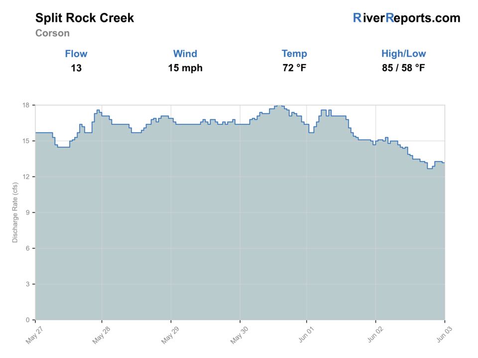
Showing the available RiverReports chart while the current structured flow series loads. Check the chart on RiverReports Opens in a new tab.
No single best way to fish. Wading and Bank fishing have the same top score. Use current access, footing, weather, and local rules to choose.
Rating updatedRiver local time:
This month is not listed as a top seasonal window in this page's reviewed season notes. Use current regulations, flow, temperature, and access checks before treating the score as a slam dunk.
NWS air forecast near
This is an air forecast, not a river-temperature reading.
RiverReports gauge
Showing the available RiverReports chart while the current structured flow series loads. Check the chart on RiverReports Opens in a new tab.
Mostly Sunny
The National Weather Service forecast is temporarily unavailable.
RiverReports gauge: Split Rock Creek near Corson
Seasonal starting points, not a live hatch report. Match what you see on the water.
Also try crayfish fly
Each fly name opens its matching Fly Box guide.
The best Split Rock days come in spring, early summer, and early fall when the creek still has enough push to concentrate fish and enough clarity to fish streamers or poppers around the edges. If the creek is a brown flood, flat and warm, or choked by weeds and summer stagnation, treat it as a scouting day or move to bigger South Dakota water.
Best for streamer and popper work around bank cover, mid-creek ledges, and rocky current tongues.
Often the strongest planning window because fish spread through the pools without the worst summer heat.
Fish early, target shade and deeper bends, and expect fewer quality lanes outside the named public corridors.
A skip signal because the creek loses clarity and safe footing quickly once prairie runoff takes over.
Wading and Bank fishing have the same top score. Use current access, footing, weather, and local rules to choose.
Wading is in play only where your chosen access has clear footing, legal entry, and no forced crossings.
Bank and edge fishing remains a practical low-commitment option if access is legal and footing is safe.
This report does not recommend floating this reach.
Is Split Rock Creek worth the trip today? Check flow, weather, hatches, access, and rules for South Dakota before you go.
Split Rock Creek is most useful when RiverReports and USGS 06482610 show enough current to define pools and cut-bank seams, when the water still has clarity, and when you are content to fish one public area well. This is not a page for invented trout marketing or endless access. It is a warmwater creek plan built around Garretson City Park, Palisades State Park, and the species South Dakota Game, Fish and Parks actually lists for the creek.
This month is not listed as a top seasonal window in this page's reviewed season notes. Use current regulations, flow, temperature, and access checks before treating the score as a slam dunk.
USGS shows 18 cfs. The flow has been stable over about 6 hours. USGS marks this reading provisional and may revise it. USGS records for this date (1966-2026, 49 readings) show a typical middle range of 15 cfs to 82 cfs. Flow is within the typical range for this date, so weather, temperature, and access become the next checks.
The current NWS air forecast is about 58F, and the next 24-hour high reaches about 76F. Mostly Sunny.
No active NWS alert was returned for this forecast point.
Skip when storm runoff is muddying the creek, current is pushy around quartzite, heat is unsafe, water is too skinny, or access is not clearly public.
Use the Corson gauge with clarity, depth, and storm history. Stable or falling flow is the best warmwater signal.
Skip when storm runoff is muddying the creek, current is pushy around quartzite, heat is unsafe, water is too skinny, or access is not clearly public.
Start with the Corson gauge, then choose Garretson City Park or Palisades State Park before picking flies or lures.
Use Palisades, a different Garretson access, or a Black Hills trout page only after checking whether the issue is mud, heat, or access.
Use these places as starting points. Open the access link below and check posted signs before you park or enter.
Check the current South Dakota fishing handbook and license requirements before fishing, then follow all posted park, city, and access-site rules where you enter the creek.
The named public access point in South Dakota's fishing guide and the cleanest place to start a first Split Rock scouting day.
The most scenic public area on the creek, with quartzite walls, tighter structure, and easy justification for a shorter focused wade.
A downstream reference area where the official gauge helps decide whether the lower creek has enough shape to fish.
Worth considering only after verifying legal public access and safe parking first.
Official agencies and primary river operators come first. Secondary tools are labeled so you know what carries the most weight.
Check what is allowed, where the rule applies, and whether the river is open.
Check the latest river reading and forecast before you leave.
Check public entry points, land rules, and seasonal access changes.
Use these links for stocking, safety, and other local details.
Check what is allowed, where the rule applies, and whether the river is open.
Open the current rules and check the river section, season, and special limits.
Open the current rules and check the river section, season, and special limits.
Check the latest river reading and forecast before you leave.
Open this page and check the latest safety advice before your trip.
Open this river reading to check the latest level, flow, and update time.
Open this river reading to check the latest level, flow, and update time.
Check public entry points, land rules, and seasonal access changes.
Open the land or access page, then check signs before you park or enter.
Use these links for stocking, safety, and other local details.
Open this page for more river information and check when it was last updated.
What was checked: This report starts with official regulation, access, flow, weather, and public-water sources, then adds practical planning guidance for fly anglers.
Live measurements and forecasts keep their provider timestamps. Rules, access, and trip guidance use the source-review date shown here. BlueStreamFly planning advice is editorial interpretation, not an agency notice.
First-hand experience: BlueStreamFly does not claim a first-hand visit or local field test for this report unless a real contributor is explicitly named and linked.
This page is not built as a trout pitch. South Dakota's public fishing guide lists warmwater species here, so the better fly-fishing plan is bass, pike, panfish, and occasional deeper-pool predators.
Start at Garretson City Park or Palisades State Park. Those are the cleanest official public access anchors for first-time scouting and fishing.
Skip it when heavy rain has turned the creek muddy, when late-summer heat leaves it flat and stagnant, or when your only plan depends on unverified roadside access.






