RiverReports preview · current series loading
Recent flow
RiverReports gauge
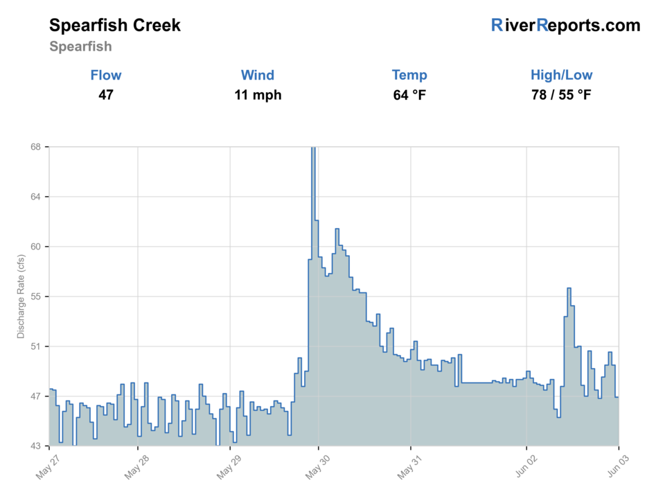
Showing the available RiverReports chart while the current structured flow series loads. Check the chart on RiverReports Opens in a new tab.
Live data is incomplete for this page, so use the linked sources before committing to the drive.
Rating updatedRiver local time:
An active alert is in effect: Red Flag Warning issued October 22 at 7:38PM MDT until October 23 at 11:00PM MDT by NWS Rapid City SD. Check public safety sources before going.
Red Flag Warning issued October 22 at 7:38PM MDT until October 23 at 11:00PM MDT by NWS Rapid City SD
NWS air forecast near
This is an air forecast, not a river-temperature reading. Check the water with a stream thermometer before fishing in hot weather.
RiverReports gauge
Showing the available RiverReports chart while the current structured flow series loads. Check the chart on RiverReports Opens in a new tab.
Partly Cloudy
The National Weather Service forecast is temporarily unavailable.
RiverReports gauge: Spearfish Creek at Spearfish
Seasonal starting points, not a live hatch report. Match what you see on the water.
Each fly name opens its matching Fly Box guide.
The best Spearfish city-area days come on stable modest flow with cool water and enough time to fish around the park users instead of through them. Early and late windows matter more here than in the canyon because easy access means the obvious fish get looked at constantly.
Best for short nymph drifts, dry-droppers, and patient coverage of park-side holding water.
Fish tight to cover, keep wading to a minimum, and use the path to change angle instead of charging the bank.
Focus on the softest seams near named access and skip the day if the creek loses the clean visual lanes that make this route worthwhile.
Expect heavy public use and choose the quieter shoulders of the day or a canyon backup.
We could not confirm all current conditions. Check locally before choosing how to fish.
Current conditions at the exact access are not verified. No access method is recommended until they are checked.
Current conditions at the exact access are not verified. No access method is recommended until they are checked.
Current conditions at the exact access are not verified. No access method is recommended until they are checked.
Is Spearfish Creek worth the trip today? Check flow, weather, hatches, access, and rules for Spearfish, South Dakota before you go.
Spearfish Creek through town is distinct from the canyon reach because the city parks, recreation trail, and preservation work create a clearly public urban area with different pressure and presentation demands. Start with the RiverReports chart, keep USGS 06431500 open, and build the day around City Park, Brady Park, and connected trail water rather than assuming the whole downtown stretch fishes evenly.
An active alert is in effect: Red Flag Warning issued October 22 at 7:38PM MDT until October 23 at 11:00PM MDT by NWS Rapid City SD. Check public safety sources before going.
The USGS flow observation is 12 hours old. Treat the rating as a live-source check, not a current fishing call, until the gauge updates.
USGS shows 36 cfs. The flow has been stable over about 6 hours. USGS marks this reading provisional and may revise it. USGS records for this date (1947-2026, 80 readings) show a median near 48 cfs and the lower quartile near 39 cfs; today's flow is below normal for the date. This is below normal, so edge depth, temperature, and pressure matter.
Fall: A top town-corridor window for cooler water, lighter recreation pressure, and better brown-trout intent.
The current NWS air forecast is about 59F, and the next 24-hour high reaches about 77F. Partly Cloudy.
Use the Spearfish gauge with clarity and park conditions. Stable or slowly falling town flow is the best signal.
Skip when stormwater is coloring the creek, flow is rising hard, water is warm, crossings are unsafe, or tubing, walkers, and park pressure make the area awkward.
Start with the Spearfish gauge, then choose Cedar Run-style gauge-area checks from City Park, Brady Park, or the recreation trail before picking flies.
Compare Spearfish Canyon, Rapid Creek Below Pactola, or Castle Creek Below Deerfield when town water is stormy, warm, crowded, or stained.
Use these places as starting points. Open the access link below and check posted signs before you park or enter.
Recheck the 2026 South Dakota Fishing Handbook and current state rules before fishing. Black Hills trout rules still apply on the Spearfish town reach.
The clearest in-town starting point thanks to direct creek access, fishing access, and easy parking.
A good second stop with confirmed fishing access and recreation-path connection.
Useful for linking short public stretches instead of treating the creek as one continuous blind wade.
Official agencies and primary river operators come first. Secondary tools are labeled so you know what carries the most weight.
Check what is allowed, where the rule applies, and whether the river is open.
Check the latest river reading and forecast before you leave.
Check public entry points, land rules, and seasonal access changes.
Use these links for stocking, safety, and other local details.
Check what is allowed, where the rule applies, and whether the river is open.
Open the current rules and check the river section, season, and special limits.
Check the latest river reading and forecast before you leave.
Open this page and check the latest safety advice before your trip.
Open this river reading to check the latest level, flow, and update time.
Open this river reading to check the latest level, flow, and update time.
Check public entry points, land rules, and seasonal access changes.
Open the land or access page, then check signs before you park or enter.
Open the land or access page, then check signs before you park or enter.
Open the land or access page, then check signs before you park or enter.
Use these links for stocking, safety, and other local details.
Open this page for more river information and check when it was last updated.
What was checked: This report starts with official regulation, access, flow, weather, and public-land sources, then adds practical planning guidance for fly anglers.
Live measurements and forecasts keep their provider timestamps. Rules, access, and trip guidance use the source-review date shown here. BlueStreamFly planning advice is editorial interpretation, not an agency notice.
First-hand experience: BlueStreamFly does not claim a first-hand visit or local field test for this report unless a real contributor is explicitly named and linked.
Use RiverReports for the live chart and keep USGS site 06431500 at Spearfish open as the official town-reach reference.
Spearfish City Park is the clearest first stop, with Brady Park and the connected recreation trail as the next public options.
This route focuses on the town area through Spearfish, where easy public access and heavier pressure change how the creek fishes.











