Wade · Best fit70/100
Wading is in play only where your chosen access has clear footing, legal entry, and no forced crossings.
Fly fishing report · Northeast
A Wilmington-area West Branch Ausable report for pocket-water trout, DEC regulation reaches, hatches, flow context, access, and wading safety.
Check flow & weatherCurrent USGS flow is 328 cfs and has been stable for about 6 hours. Today's flow is near the high side of the normal seasonal range, which tops out near 340 cfs. This is near the high side of normal, so be careful about wading, clarity, and pushy current before calling it good.
Compare wading, bank fishing, and floating before choosing how you will fish.
Wading is in play only where your chosen access has clear footing, legal entry, and no forced crossings.
Bank and edge fishing remains a practical low-commitment option if access is legal and footing is safe.
This report does not describe this as a primary mode. Verify legal access, depth, launches, and retreat options before planning around it.
Check before you drive
Look at whether the river is rising or falling, then check wind, rain, and storms. These can change both safety and fishing.
Before you rely on this report
Conditions can change quickly. Check these dates before you decide to fish, and open the official source when safety or rules matter.
High confidence in the current score inputs.
7 sources are listed below for you to open.
3 public access records are listed. Private spots are never shown.
Source checked Jul 30, 2026
Plan your access
These are public parking, launch, trail, or recreation areas—not secret fishing spots. We never show an angler's private pins, notes, or photos here.
Area description
Core West Branch planning area with named regulation segments nearby.
Use DEC public fishing rights, state land, and posted signs to confirm legal access.
Public rights do not mean you can cross private yards or leave the stream corridor.
Area description
Important DEC regulation boundary context for reach selection.
Use DEC public fishing rights, state land, and posted signs to confirm legal access.
Public rights do not mean you can cross private yards or leave the stream corridor.
Area description
Upper reach planning context with changing rules and access.
Use DEC public fishing rights, state land, and posted signs to confirm legal access.
Public rights do not mean you can cross private yards or leave the stream corridor.
How to fish it
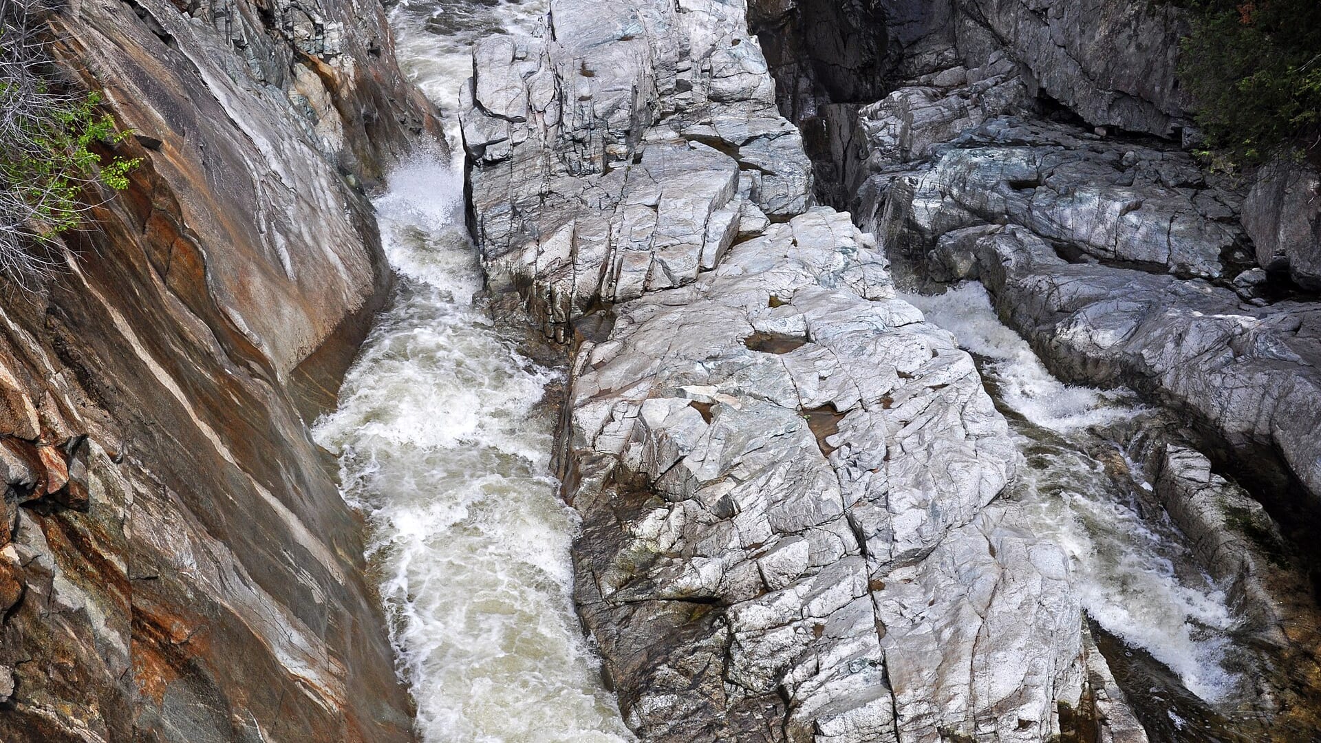
The public gauge is below the branch confluence, so it is useful context rather than a perfect West Branch reading. On the water, clarity, boulder-pocket speed, and DEC reach rules matter most.
USGS shows 328 cfs with a stable over about 6 hours trend. Today's flow is near the high side of the normal seasonal range, which tops out near 340 cfs. This is near the high side of normal, so be careful about wading, clarity, and pushy current before calling it good.
The forecast has storm or heavy-precipitation risk, so timing and access matter more than the score alone.
Summer: Morning terrestrials and caddis can work if water remains trout-safe.
The NWS forecast is about 71F with Chance Showers And Thunderstorms.
No active NWS alert was returned for this forecast point.
Read the water
The West Branch is best when flows are stable, water is cool, and pocket-water seams are readable. If the river is high, slick, or off color after mountain rain, fish short edges or wait.
Fish dry-droppers, attractor dries, and tight nymph rigs in pocket water.
Stay near the bank, avoid crossings, and fish only protected edges.
Use stealth, longer leaders, and stop trout fishing if temperatures climb.
Slow down with nymphs and streamers in deeper buckets and soft seams.
Your trip plan
Use USGS 04275500 as Ausable flow context, then pair it with recent rain, visibility, and the exact Wilmington-area reach. It is useful context, but it is not a perfect substitute for every West Branch pocket-water slot.
Skip or pivot when thunderstorms have the river rising, wading is pushy, public access is unclear, water is too warm for trout handling, or New York trout rules for the exact reach are not confirmed.
Start with Wilmington Wild Forest and public-rights context, then pick one safe reach. Fish short drifts, pocket seams, plunge-pool edges, and shaded banks instead of trying to cover too much water.
If the West Branch is high, crowded, warm, or access-limited, compare Esopus Creek for another mountain trout plan, the Delaware West Branch for tailwater-style conditions, or Cattaraugus Creek when the goal is a Lake Erie tributary trip.
Hatches & flies
 Fly pattern · report suggests “Zebra midge”Zebra MidgeLook for a very slim tapered thread body, evenly spaced contrasting wire rib, a small bead, and no tail or wing. The reviewed classic is black with silver wire and a silver bead. Red, olive, brown, glass-bead, jig-hook, resin-coated, or tailed forms must remain labeled variations rather than replacing the classic identity.See photos & how to fish it ↗
 Fly family · report suggests “black stone nymph”Black Stonefly PatternsBlack stonefly wording is a color and insect-group label, not one exact recipe. Size, nymph versus adult stage, wing profile, and weighting must remain explicit.See family guide ↗+ 3 more reviewed guides in the Fly Box
  Fly family · report suggests “March Brown”March Brown Dry FliesThis family includes traditional hackled, parachute, and Comparadun-style March Brown dries. Each exact construction rides differently and should be named when known.See family guide ↗
 Fly family · report suggests “sulphur emerger”Sulphur Mayfly PatternsSulphur is hatch wording. Nymphs, emergers, Comparaduns, parachutes, traditional dries, soft hackles, and spinners have different silhouettes and depths.See family guide ↗+ 3 more reviewed guides in the Fly Box
  Fly pattern · report suggests “Stimulator”StimulatorLook for a hair tail, dubbed abdomen with palmered hackle, tented hair wing, contrasting front hackle, and bright thorax or head. Colors and sizes vary widely and must remain labeled.See photos & how to fish it ↗
 Fly pattern · report suggests “parachute Adams”Parachute AdamsThe upright light post and horizontal parachute hackle are the defining visual cues. The classic pilot example uses a gray-brown body and divided tail, but color and size variations should be labeled instead of treated as identical.See photos & how to fish it ↗+ 4 more reviewed guides in the Fly Box
  Fly family · report suggests “BWO”Blue-Winged Olive PatternsBWO describes a hatch group, not one fly. Nymph, emerger, dry, cripple, and spinner profiles must stay separate because they occupy different parts of the water column.See family guide ↗
 Fly family · report suggests “October caddis”October Caddis PatternsOctober Caddis names a hatch group. Amber or orange pupae, soft-hackle or wet forms, and large tent-wing adults fish at different levels.See family guide ↗+ 3 more reviewed guides in the Fly Box
 Fish upstream and cover the close pockets before stepping into the river.
Use buoyant attractors with small tungsten droppers in broken current.
Tight-line nymph short slots instead of forcing long indicator drifts through boulders.
Switch to a small streamer when the river is up but still safe and clear enough to fish.
Keep moving, but give each pocket a careful first drift before wading through it.
Rules & closures
Open the agency page to confirm the exact river section, species, season, tackle rules, limits, and emergency closures.
Official links checkedWe checked the state source but did not find a clearly supported exception for this river. Check the official rules for the exact section you plan to fish.
This summary helps with trip planning. The linked agency rule is the one you must follow.
Updates from anglers
Recent observations from general areas of Ausable River, West Branch. We review every update before it appears and never publish exact fishing spots, private access details, or photo locations.
You can still use the river plan above. Check back later for recent observations from other anglers.
Where this report comes from
Fishing guidance checked: May 31, 2026
Site check: Jul 14, 2026. We regularly test report links, live scores, flow and weather data, and page loading. The content date changes only when the fishing guidance or its sources change.
Common questions
Check the Au Sable Forks gauge trend, local water clarity, DEC reach rules, mountain weather, and water temperature.
Yes. DEC lists several reach categories on the West Branch, including catch-and-release sections.
Bring the hatch-chart flies, a small nymph box, and a few streamers. Then adjust for water temperature, clarity, pressure, and the insects or baitfish you actually see.
Often yes, but it is slick and fast pocket water. Avoid high flows and unnecessary crossings.
Skip it when flows are unsafe, water is too warm for trout, emergency closures are active, or legal access for the reach is not clear.