RiverReports preview · current series loading
Recent flow
RiverReports gauge
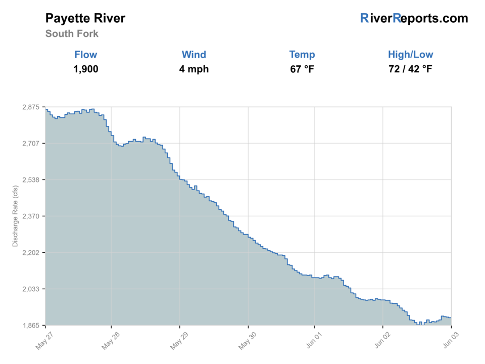
Showing the available RiverReports chart while the current structured flow series loads. Check the chart on RiverReports Opens in a new tab.
No single best way to fish. Wading and Bank fishing have the same top score. Use current access, footing, weather, and local rules to choose.
Check first: Water temperature is unconfirmed. Use a stream thermometer before fishing.
Rating updatedRiver local time:
This month is not listed as a top seasonal window in this page's reviewed season notes. Use current regulations, flow, temperature, and access checks before treating the score as a slam dunk.
NWS air forecast near
This is an air forecast, not a river-temperature reading. Check the water with a stream thermometer before fishing in hot weather.
RiverReports gauge
Showing the available RiverReports chart while the current structured flow series loads. Check the chart on RiverReports Opens in a new tab.
Sunny
The National Weather Service forecast is temporarily unavailable.
RiverReports gauge: South Fork Payette River at Lowman
Seasonal starting points, not a live hatch report. Match what you see on the water.
Also try hopper-dropper
Each fly name opens its matching Fly Box guide.
This page is strongest from late spring through early fall when flows settle enough to create fishable current lanes and when mornings still leave the colder canyon water feeling like trout water instead of just whitewater scenery.
Best for pocket-water nymphing, short dry-dropper drifts, and safer bank access.
A good time to spot structure, but fish can slide into smaller softer holding lies.
Scale back immediately. Fast current turns many pretty runs into poor wading decisions.
Slow down with nymphs and target softer inside edges near official access.
Wading and Bank fishing have the same top score. Use current access, footing, weather, and local rules to choose.
Wading is in play only where your chosen access has clear footing, legal entry, and no forced crossings.
Bank and edge fishing remains a practical low-commitment option if access is legal and footing is safe.
This report does not recommend floating this reach.
Is South Fork Payette River worth the trip today? Check flow, weather, hatches, access, and rules for Idaho before you go.
The South Fork Payette can offer strong trout water, but it is still a gradient river with long stretches that demand restraint. The best fishing days happen when flows are moderate enough to expose real edge water, and when you treat named public sites as your anchor instead of improvising from every turnout.
This month is not listed as a top seasonal window in this page's reviewed season notes. Use current regulations, flow, temperature, and access checks before treating the score as a slam dunk.
The current NWS air forecast is about 64F, and the next 24-hour high reaches about 89F. This is an air forecast, not a water-temperature reading. Fish early and check the river with a stream thermometer.
Wade: Wading is in play only where your chosen access has clear footing, legal entry, and no forced crossings.
USGS shows 324 cfs. The flow has been stable over about 6 hours. USGS marks this reading provisional and may revise it. USGS records for this date (1942-2026, 85 readings) show a typical middle range of 303 cfs to 403 cfs. Flow is within the typical range for this date, so weather, temperature, and access become the next checks.
No active NWS alert was returned for this forecast point.
Moderate flows that expose inside seams, pocket-water edges, and short safe entries without flattening the river's current definition.
Skip when runoff or release-driven push erases soft edges, or when your first two access stops already require riskier wading than the fishing is worth.
Check the Lowman gauge, choose one named public site, and fish the first soft structure you find instead of chasing the loudest water in sight.
If the South Fork is too pushy, drop to the broader Payette area for easier scouting or move to Deadwood for a colder more controlled backup plan.
Use these places as starting points. Open the access link below and check posted signs before you park or enter.
IDFG's 2025-2027 rules list a 2-trout limit for the South Fork Payette River and its smaller streams, except where the Middle Fork carries different language. Check the current planner before mixing sections on the same day.
A BLM access anchor east of Garden Valley for short focused sessions.
A practical downstream public site when you want a clear put-in or take-out reference.
Forest Service sites that keep Lowman-side access and bank scouting straightforward.
Official agencies and primary river operators come first. Secondary tools are labeled so you know what carries the most weight.
Check what is allowed, where the rule applies, and whether the river is open.
Check the latest river reading and forecast before you leave.
Check public entry points, land rules, and seasonal access changes.
Check what is allowed, where the rule applies, and whether the river is open.
Open the current rules and check the river section, season, and special limits.
Check the latest river reading and forecast before you leave.
Open this page and check the latest safety advice before your trip.
Open this river reading to check the latest level, flow, and update time.
Open this river reading to check the latest level, flow, and update time.
Check public entry points, land rules, and seasonal access changes.
Open the land or access page, then check signs before you park or enter.
Open the land or access page, then check signs before you park or enter.
Open the land or access page, then check signs before you park or enter.
Open the land or access page, then check signs before you park or enter.
What was checked: This report uses official regulation, flow, weather, and public-access sources first, then adds practical planning guidance for fly anglers.
Live measurements and forecasts keep their provider timestamps. Rules, access, and trip guidance use the source-review date shown here. BlueStreamFly planning advice is editorial interpretation, not an agency notice.
First-hand experience: BlueStreamFly does not claim a first-hand visit or local field test for this report unless a real contributor is explicitly named and linked.
It is fishable from the bank and by wading, but only in selective spots. The river rewards restraint far more than aggressive coverage.
Start with RiverReports and USGS 13235000 at Lowman because they reflect the area this page is built around.
Move when the gauge and the bank both tell you the day is too pushy, or when every decent seam requires unsafe footing to reach.


