RiverReports preview · current series loading
Recent flow
RiverReports gauge
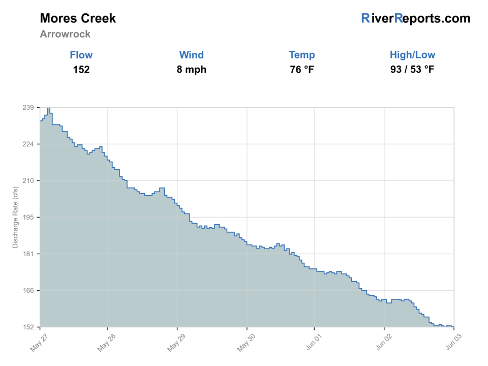
Showing the available RiverReports chart while the current structured flow series loads. Check the chart on RiverReports Opens in a new tab.
No access method is recommended today. Review the live conditions below before choosing another river or day.
Rating updatedRiver local time:
An active alert is in effect: Flash Flood Watch issued October 21 at 10:09PM MDT until October 23 at 12:00PM MDT by NWS Boise ID. Check public safety sources before going.
Flash Flood Watch issued October 21 at 10:09PM MDT until October 23 at 12:00PM MDT by NWS Boise ID
NWS air forecast near
This is an air forecast, not a river-temperature reading. Check the water with a stream thermometer before fishing in hot weather.
RiverReports gauge
Showing the available RiverReports chart while the current structured flow series loads. Check the chart on RiverReports Opens in a new tab.
Mostly Sunny
The National Weather Service forecast is temporarily unavailable.
RiverReports gauge: Mores Creek above Robie Creek near Arrowrock Dam
Seasonal starting points, not a live hatch report. Match what you see on the water.
Also try hopper-dropper
Each fly name opens its matching Fly Box guide.
Mores Creek is strongest as a fast-planning local trout day in spring, early summer, and cooler fall windows. It is weakest when anglers treat a small accessible creek as if it should fish big all day through hot weather and low water.
The best condition for short dry-dropper or light nymph sessions along the Highway 21 area.
Fish early, downsize, and focus on shade, current seams, and undercut banks.
Treat the creek as a scouting stop or move on. Small roadside water gets hard to read quickly when color rises.
If the water feels too warm or shallow, shorten the trip or skip it rather than forcing trout to pay for a marginal window.
No access method is recommended in today's conditions. Review the live river and weather checks before making another plan.
Not recommended today. Recheck the river, weather, and access before planning another trip.
Not recommended today. Recheck the river, weather, and access before planning another trip.
Not recommended today. Recheck the river, weather, and access before planning another trip.
Is Mores Creek worth the trip today? Check flow, weather, hatches, access, and rules for Idaho before you go.
This is one of the simplest Boise-area trout options to reach, but it should be approached as an access-friendly small-river day, not a destination-size trophy fishery. Check the flow first, then decide whether you are looking for a short rainbow-and-whitefish session or whether low water and warm afternoons have already cut the window down too far.
An active alert is in effect: Flash Flood Watch issued October 21 at 10:09PM MDT until October 23 at 12:00PM MDT by NWS Boise ID. Check public safety sources before going.
USGS shows 30 cfs. The flow has been stable over about 6 hours. USGS marks this reading provisional and may revise it. USGS records for this date (1951-2026, 76 readings) show a median near 57 cfs and a low-water marker near 34 cfs; today's flow is unusually low for the date. Low water can make fish spooky, warm, pressured, or concentrated; check temperature and handling risk.
Fall: Often a cleaner short-trip option once nights cool and the corridor quiets down.
The current NWS air forecast is about 48F, and the next 24-hour high reaches about 75F. Mostly Sunny.
Skip when hot afternoons, shallow water, or muddy runoff turn the creek into a temperature or visibility compromise.
Cool moderate flows that keep roadside pockets alive without burying the creek in runoff color.
Skip when hot afternoons, shallow water, or muddy runoff turn the creek into a temperature or visibility compromise.
Fish early, start at one official access like Grayback or Bad Bear, and build the day out from the first stretch that still has cool moving water and clean holding seams.
If Mores Creek looks too thin or warm, switch to Boise River for bigger water or plan a cooler remote option like Deadwood instead of trying to squeeze a bad window.
Use these places as starting points. Open the access link below and check posted signs before you park or enter.
IDFG lists no special rules for Mores Creek under the 2025-2027 fishing planner, so Southwest Region general bag limits apply. The same planner also notes that stocked hatchery rainbow trout provide most of the regular opportunity here.
A solid official Forest Service anchor above Idaho City with direct creek access below camp.
Useful lower-area access where the creek runs right along Highway 21.
IDFG's directions make clear that much of the creek is reached through roadside pullouts, which is the core strength of this fishery.
Official agencies and primary river operators come first. Secondary tools are labeled so you know what carries the most weight.
Check what is allowed, where the rule applies, and whether the river is open.
Check the latest river reading and forecast before you leave.
Check public entry points, land rules, and seasonal access changes.
Check what is allowed, where the rule applies, and whether the river is open.
Open the current rules and check the river section, season, and special limits.
Check the latest river reading and forecast before you leave.
Open this page and check the latest safety advice before your trip.
Open this river reading to check the latest level, flow, and update time.
Open this river reading to check the latest level, flow, and update time.
Check public entry points, land rules, and seasonal access changes.
Open the land or access page, then check signs before you park or enter.
Open the land or access page, then check signs before you park or enter.
What was checked: This report uses official regulation, flow, weather, and public-access sources first, then adds practical planning guidance for fly anglers.
Live measurements and forecasts keep their provider timestamps. Rules, access, and trip guidance use the source-review date shown here. BlueStreamFly planning advice is editorial interpretation, not an agency notice.
First-hand experience: BlueStreamFly does not claim a first-hand visit or local field test for this report unless a real contributor is explicitly named and linked.
Yes, when you treat it as a practical close-to-Boise trout creek with realistic expectations instead of a destination-sized river.
Watch flow, water temperature, and how much pressure the Highway 21 area is taking that day.
Start with RiverReports and USGS 13200000 above Robie Creek near Arrowrock Dam for the broad area trend.