Wade, bank, and floatPaused
Approach recommendations stay hidden until the hard stop clears.
Fly fishing report · West
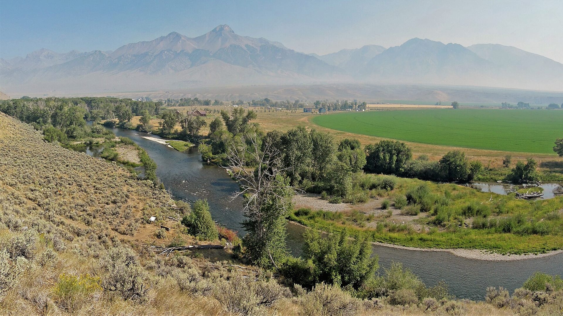
A Big Lost River report for the Mackay tailwater and valley access, RiverReports/USGS flow checks, IDFG rules, whitefish protection, hatches, flies, and dewatering cautions.
Check flow & weatherRed Flag Warning issued August 2 at 1:04AM MDT until August 2 at 9:00PM MDT by NWS Pocatello ID
Red Flag Warning issued August 2 at 1:04AM MDT until August 2 at 9:00PM MDT by NWS Pocatello ID
The active safety or closure reason takes priority over wading, bank fishing, and floating guidance.
Approach recommendations stay hidden until the hard stop clears.
Check before you drive
Look at whether the river is rising or falling, then check wind, rain, and storms. These can change both safety and fishing.
Before you rely on this report
Conditions can change quickly. Check these dates before you decide to fish, and open the official source when safety or rules matter.
High confidence in the current score inputs.
7 sources are listed below for you to open.
4 public access records are listed. Private spots are never shown.
Source checked Jul 30, 2026
Plan your access
These are public parking, launch, trail, or recreation areas—not secret fishing spots. We never show an angler's private pins, notes, or photos here.
Area description
The main tailwater and flow-reference reach for this report.
Irrigation and dewatering can change fishability by reach.
Private land is common enough that maps matter.
Area description
Official access-site context for lower-river planning.
Irrigation and dewatering can change fishability by reach.
Private land is common enough that maps matter.
Trailhead
Public-land access context with remote travel considerations.
Irrigation and dewatering can change fishability by reach.
Private land is common enough that maps matter.
Roadside access
A colder and more remote upper-drainage plan with forest-road logistics.
Irrigation and dewatering can change fishability by reach.
Private land is common enough that maps matter.
How to fish it
The Big Lost is a high-desert trout river where Mackay Reservoir releases, irrigation, and access define the day. Use the below-Mackay gauge, then decide whether you are fishing tailwater, valley, or upper drainage water.
An active alert is in effect: Red Flag Warning issued August 2 at 1:04AM MDT until August 2 at 9:00PM MDT by NWS Pocatello ID. Check public safety sources before going.
USGS shows 399 cfs with a stable over about 6 hours trend. Today's flow is within the normal seasonal range of 348 cfs to 637 cfs. Weather, water temperature, and access are the next checks.
Summer: Caddis, PMDs, stones, and terrestrials matter, but heat and irrigation flows decide the day.
The NWS forecast is about 83F with Patchy Smoke.
Skip the Big Lost when flows are too low for responsible trout handling, when IDFG rules or whitefish language are unclear, when private-bank access is the only realistic entry, or when remote weather and road conditions make the drive a poor trade.
Read the water
The Big Lost is best when flows are stable enough for safe wading and cold enough for careful trout handling. If irrigation, heat, or dewatering make the river poor, move higher or choose a nearby alternative.
Use stealth, smaller flies, and avoid pushing fish in shallow warm water.
Nymph rigs, dry-droppers, and attractor dries can cover riffles and buckets.
Avoid risky crossings and fish softer banks only where access is legal.
Do not force a trout plan; move to water with enough cold flow or use a backup river.
Your trip plan
Use the RiverReports Mackay chart and USGS 13127000 together. Stable tailwater releases create the best window; dewatering, sudden irrigation changes, or very low warm water should move you to a different reach or another river.
Skip the Big Lost when flows are too low for responsible trout handling, when IDFG rules or whitefish language are unclear, when private-bank access is the only realistic entry, or when remote weather and road conditions make the drive a poor trade.
Start with the Mackay tailwater and IDFG lower access context, then compare BLM trail or upper Forest Service water only if road, weather, and flow conditions support the extra travel.
If the Big Lost is dewatered, too warm, or access-limited, compare the Big Wood River, Boise River, or another Idaho trout option after checking current rules and flows.
Hatches & flies
 Fly family · report suggests “BWO emerger”Blue-Winged Olive PatternsBWO describes a hatch group, not one fly. Nymph, emerger, dry, cripple, and spinner profiles must stay separate because they occupy different parts of the water column.See family guide ↗
 Fly pattern · report suggests “zebra midge”Zebra MidgeLook for a very slim tapered thread body, evenly spaced contrasting wire rib, a small bead, and no tail or wing. The reviewed classic is black with silver wire and a silver bead. Red, olive, brown, glass-bead, jig-hook, resin-coated, or tailed forms must remain labeled variations rather than replacing the classic identity.See photos & how to fish it ↗+ 2 more reviewed guides in the Fly Box
  Fly family · report suggests “PMD dry”Pale Morning Dun PatternsPMD names an insect group, not one fly. Pale nymphs, trailing-shuck emergers, upright or low-riding duns, cripples, and spent-wing spinners stay visibly separate.See family guide ↗
 Fly pattern · report suggests “elk hair caddis”Elk Hair CaddisLook for a tented elk- or deer-hair wing, clipped hair head, dubbed body, rib, and hackle palmered along the body. The body color should be labeled because tiers often match different natural caddis colors.See photos & how to fish it ↗+ 2 more reviewed guides in the Fly Box
  Fly family · report suggests “Ant”Ant PatternsAnt patterns can be foam, fur-bodied, winged, or sunken. The narrow waist and paired body lobes matter more than one material recipe.See family guide ↗
 Fly family · report suggests “beetle”Beetle PatternsBeetle flies range from simple foam shells to hair-bodied and sunken forms. A rounded back and compact profile distinguish the family from ants and hoppers.See family guide ↗+ 3 more reviewed guides in the Fly Box Fly family · report suggests “BWO dry”Blue-Winged Olive PatternsBWO describes a hatch group, not one fly. Nymph, emerger, dry, cripple, and spinner profiles must stay separate because they occupy different parts of the water column.See family guide ↗
 Fly pattern · report suggests “RS2”RS2Start with the beadless architecture: two dark-dun Microfibett tails separated behind a slim, tightly twisted and visibly segmented dubbed abdomen; a fuller thorax; and saddle-hackle web clipped into a short angled wing bud. Rim Chung's original-style form uses natural beaver dubbing and hackle web. CDC- or Antron-wing ties, beads, curved hooks, flash, and tailless Avatar-style flies must remain labeled variations.See photos & how to fish it ↗+ 2 more reviewed guides in the Fly Box
 Check whether the river has enough cold water for the reach you plan to fish.
Use the Mackay gauge for tailwater planning, not lower-basin assumptions.
Fish banks and riffle edges with dry-droppers during summer.
Respect private land and use official access sites when possible.
Handle mountain whitefish according to current IDFG rules.
Rules & closures
Open the agency page to confirm the exact river section, species, season, tackle rules, limits, and emergency closures.
Official links checkedWe checked the state source but did not find a clearly supported exception for this river. Check the official rules for the exact section you plan to fish.
This summary helps with trip planning. The linked agency rule is the one you must follow.
Updates from anglers
Recent observations from general areas of Big Lost River. We review every update before it appears and never publish exact fishing spots, private access details, or photo locations.
You can still use the river plan above. Check back later for recent observations from other anglers.
Where this report comes from
Fishing guidance checked: May 31, 2026
Site check: Jul 14, 2026. We regularly test report links, live scores, flow and weather data, and page loading. The content date changes only when the fishing guidance or its sources change.
Common questions
It focuses on the below-Mackay Reservoir tailwater and valley access, with upper drainage context.
Use USGS 13127000 below Mackay Reservoir, shown through RiverReports and official USGS.
Irrigation and basin conditions can leave some lower reaches with poor or intermittent surface flow.
Yes. IDFG special rules can apply, so check current Idaho rules before harvest or handling assumptions.