RiverReports chart
Recent flow
RiverReports gauge
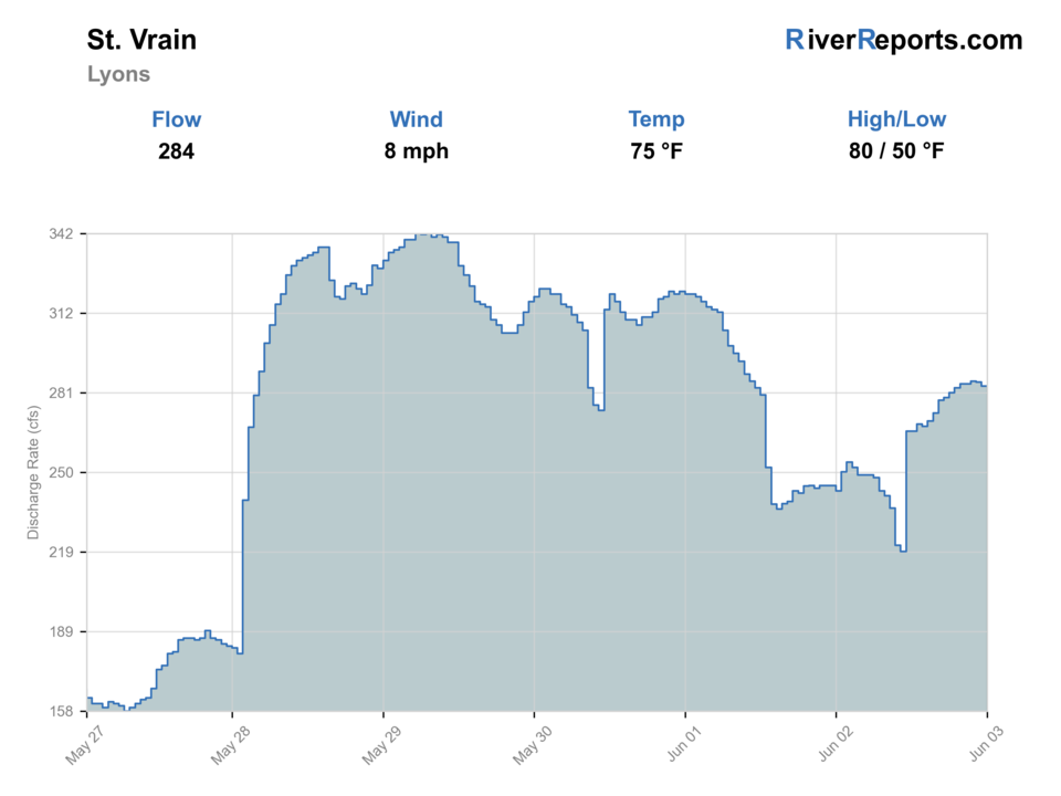
BlueStreamFly cannot read the latest value from this image. Check the chart on RiverReports Opens in a new tab.
If you go: Floating. A float is in play where this report supports boat access and wind, releases, and shuttle logistics are manageable.
Check first: No structured live flow
Rating updatedRiver local time:
Float: A float is in play where this report supports boat access and wind, releases, and shuttle logistics are manageable.
NWS air forecast near
This is an air forecast, not a river-temperature reading. Check the water with a stream thermometer before fishing in hot weather.
RiverReports gauge
BlueStreamFly cannot read the latest value from this image. Check the chart on RiverReports Opens in a new tab.
Chance Rain Showers
The National Weather Service forecast is temporarily unavailable.
RiverReports gauge: Saint Vrain Creek at Lyons
Seasonal starting points, not a live hatch report. Match what you see on the water.
Also try hopper-dropper
Each fly name opens its matching Fly Box guide.
Late summer and early fall are usually the cleanest windows for the Lyons area. Runoff, afternoon storms, and warm lower-elevation afternoons can all shrink the useful fishing window faster than the map suggests.
Fish small dries and light droppers, stay low, and make the first cast count.
Best all-around condition for dry-droppers, pocket-water nymphs, and short seam work.
Treat the creek as a scouting stop only if crossings disappear and the water loses shape.
Fish early, shorten trout handling, and move higher or quit when the creek starts feeling stressed.
These scores compare the risks of wading, bank fishing, and floating.
Wading is in play only where your chosen access has clear footing, legal entry, and no forced crossings.
This report does not recommend bank fishing on this reach.
A float is in play where this report supports boat access and wind, releases, and shuttle logistics are manageable.
Is St. Vrain worth the trip today? Check flow, weather, hatches, access, and rules for Colorado before you go.
The St. Vrain around Lyons is most useful when flows are stable enough to read small seams, the canyon pullouts are not crowded, and you keep the plan centered on clean entries rather than trying to force distance. This is a creek that rewards stealth, quick adjustments, and realistic expectations about size and room.
Float: A float is in play where this report supports boat access and wind, releases, and shuttle logistics are manageable.
RiverReports is linked for the flow chart, but this page does not have a structured live flow value the score can read automatically. Treat the rating as conservative and open the chart before committing.
This month is not listed as a top seasonal window in this page's reviewed season notes. Use current regulations, flow, temperature, and access checks before treating the score as a slam dunk.
The current NWS air forecast is about 66F, and the next 24-hour high reaches about 75F. Chance Rain Showers.
No active NWS alert was returned for this forecast point.
Stable clear flows that leave pocket water, undercuts, and seam edges readable without forcing crossings.
Skip during runoff, after storm-color spikes, or when warm lower-elevation afternoons turn the day into a fish-handling compromise.
Check the Lyons chart, choose one South Saint Vrain access point, fish it thoroughly, then rotate only if the water or pressure demands it.
North St. Vrain, Big Thompson, or Boulder Creek are better pivots when runoff, weather, or crowding narrow St. Vrain too much.
Use these places as starting points. Open the access link below and check posted signs before you park or enter.
Check the current Colorado fishing brochure before fishing. If your plan moves into Rocky Mountain National Park, the park requires a Colorado license and uses its own catch-and-release tackle restrictions in designated waters, including barbless-hook and artificial-lure rules where posted.
An official undeveloped pullout 3.7 miles west of Lyons for short creek access.
A stronger Forest Service walk-in anchor for anglers willing to hike the creek area.
Useful only if you are intentionally moving into park water with park-specific fishing rules in mind.
Official agencies and primary river operators come first. Secondary tools are labeled so you know what carries the most weight.
Check what is allowed, where the rule applies, and whether the river is open.
Check the latest river reading and forecast before you leave.
Check public entry points, land rules, and seasonal access changes.
Check what is allowed, where the rule applies, and whether the river is open.
Open the current rules and check the river section, season, and special limits.
Open the current rules and check the river section, season, and special limits.
Open the current rules and check the river section, season, and special limits.
Check the latest river reading and forecast before you leave.
Open this page and check the latest safety advice before your trip.
Open this river reading to check the latest level, flow, and update time.
Check public entry points, land rules, and seasonal access changes.
Open the land or access page, then check signs before you park or enter.
Open the land or access page, then check signs before you park or enter.
What was checked: This report uses official regulation, flow, weather, access, and public-land sources first, then adds practical planning guidance for fly anglers.
Live measurements and forecasts keep their provider timestamps. Rules, access, and trip guidance use the source-review date shown here. BlueStreamFly planning advice is editorial interpretation, not an agency notice.
First-hand experience: BlueStreamFly does not claim a first-hand visit or local field test for this report unless a real contributor is explicitly named and linked.
It is centered on Saint Vrain Creek at Lyons with South Saint Vrain public-access context, not just the North St. Vrain preserve and not every park headwater creek.
Use the Saint Vrain Creek at Lyons RiverReports chart before deciding whether small-water pocket fishing is actually in shape.
Only if you like small-water casting and short wades. The creek is approachable, but it still punishes sloppy presentations and poor footing.