WadeNot advised
Wading is the most sensitive plan today. Use protected edges only, avoid crossings, and downgrade quickly if clarity or current feels wrong.
Fly fishing report · Southwest
A closure-aware Mogollon Rim report for trout tactics, flow checks, hatch timing, forest access, and safe trip planning near Payson.
Check flow & weatherThe NWS forecast is near 92F. Fish early and verify water temperature where trout stress is possible.
Compare wading, bank fishing, and floating before choosing how you will fish.
Wading is the most sensitive plan today. Use protected edges only, avoid crossings, and downgrade quickly if clarity or current feels wrong.
Bank and edge fishing is the safer default when water is high, pushy, or not fully verified.
A float can fit better than wading only if launches, shuttle, boat skill, wind, and local rules all check out.
Check before you drive
Look at whether the river is rising or falling, then check wind, rain, and storms. These can change both safety and fishing.
Before you rely on this report
Conditions can change quickly. Check these dates before you decide to fish, and open the official source when safety or rules matter.
High confidence in the current score inputs.
8 sources are listed below for you to open.
4 public access records are listed. Private spots are never shown.
Source checked Jul 30, 2026
Plan your access
These are public parking, launch, trail, or recreation areas—not secret fishing spots. We never show an angler's private pins, notes, or photos here.
Roadside access
Useful Rim-country access when open, but it is affected by the 2026 Forest Road 289 bridge-construction closure notices.
Tonto National Forest published a temporary closure affecting Upper and Lower Tonto Creek campgrounds and Horton Creek trailhead parking from March 9 through Dec. 31, 2026.
Forest Road 289 may remain passable during work, but delays or changing site access can still affect the day.
Area description
Forest Service campground access can put you near fishable water, but seasonal closures and construction notices must be checked.
Tonto National Forest published a temporary closure affecting Upper and Lower Tonto Creek campgrounds and Horton Creek trailhead parking from March 9 through Dec. 31, 2026.
Forest Road 289 may remain passable during work, but delays or changing site access can still affect the day.
Area description
Good for orientation and learning, but public access to fish-rearing areas is restricted and the hatchery is not a fishing beat.
Tonto National Forest published a temporary closure affecting Upper and Lower Tonto Creek campgrounds and Horton Creek trailhead parking from March 9 through Dec. 31, 2026.
Forest Road 289 may remain passable during work, but delays or changing site access can still affect the day.
Roadside access
Road access can be affected by bridge work, winter storms, and fire restrictions. Read the current alerts before relying on it.
Tonto National Forest published a temporary closure affecting Upper and Lower Tonto Creek campgrounds and Horton Creek trailhead parking from March 9 through Dec. 31, 2026.
Forest Road 289 may remain passable during work, but delays or changing site access can still affect the day.
How to fish it
Tonto Creek can be a useful small-stream trout plan, but the current trip should start with Forest Service closure notices, fire restrictions, and the downstream gauge before you drive up the Rim.
The NWS forecast is near 92F. Fish early and verify water temperature where trout stress is possible.
The forecast has storm or heavy-precipitation risk, so timing and access matter more than the score alone.
A heat alert is active near this forecast point, so the score is capped at caution until water temperature and fish-handling risk are checked. NWS alert: Extreme Heat Warning issued August 1 at 11:27AM MST until August 3 at 8:00PM MST by NWS Flagstaff AZ.
Float: A float can fit better than wading only if launches, shuttle, boat skill, wind, and local rules all check out.
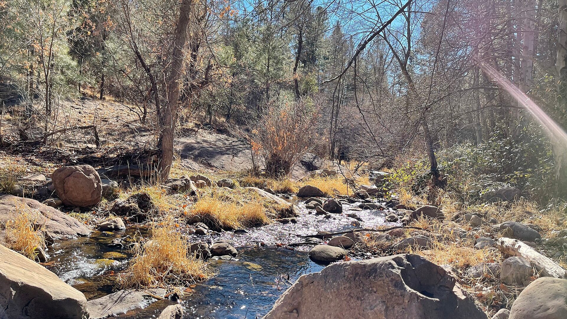
USGS shows 9 cfs with a stable over about 6 hours trend. Today's flow is within the normal seasonal range of 5 cfs to 42 cfs. Weather, water temperature, and access are the next checks.
Read the water
This is a small-water report. Short casts, quiet movement, and flexible access planning matter more than long leaders or heavy rigs. If closures or storms make the upper creek impractical, shift to nearby Rim water instead of forcing the plan.
Stay back from pools, use one light nymph or a small dry-dropper, and avoid repeated casts through the same pocket.
Cover pocket water, plunge pools, and undercut edges with short drifts and frequent fly changes.
Skip crossings and fish only soft edges if the water is safely approachable. Flash flooding can make the creek dangerous quickly.
Road snow, ice, and bridge work can matter more than the fly box. Confirm access before leaving Payson.
Your trip plan
Use RiverReports and USGS 09499000 as a trend and safety reference, then verify upper-creek clarity and access. Stable or slowly falling clear water is best; rising, stained, or storm-fed water should move the day to scouting or another route.
Skip it when Forest Service closures affect the access you planned, monsoon storms or runoff stain the creek, road conditions are unsafe, water is too warm for trout, or the downstream gauge is rising enough to make crossings questionable.
Start with the closure and fire-restriction check, then compare Horton, Upper Tonto, Lower Tonto, and accessible pocket water only after flow, weather, and road conditions still support the trip.
If Tonto Creek is closed, storm-stained, warm, or too low, compare Canyon Creek, Oak Creek, Silver Creek, or a legal Rim lake after checking current rules and access.
Hatches & flies
 Fly pattern · report suggests “Zebra midge”Zebra MidgeLook for a very slim tapered thread body, evenly spaced contrasting wire rib, a small bead, and no tail or wing. The reviewed classic is black with silver wire and a silver bead. Red, olive, brown, glass-bead, jig-hook, resin-coated, or tailed forms must remain labeled variations rather than replacing the classic identity.See photos & how to fish it ↗
 Fly pattern · report suggests “Griffith's gnat”Griffith's GnatLook for a peacock-herl body wrapped end to end with grizzly hackle and finished with a compact thread head. The classic has no separate tail, wing, upright post, bead, or trailing shuck. A high-visibility post, parachute build, or Antron shuck is a separate labeled variation or pattern—not the photographed classic.See photos & how to fish it ↗+ 2 more reviewed guides in the Fly Box
  Fly pattern · report suggests “Elk hair caddis”Elk Hair CaddisLook for a tented elk- or deer-hair wing, clipped hair head, dubbed body, rib, and hackle palmered along the body. The body color should be labeled because tiers often match different natural caddis colors.See photos & how to fish it ↗
 Fly pattern · report suggests “X-caddis”X-CaddisIdentify the X-Caddis by the combination of a sparse translucent Zelon-style trailing shuck, slim dubbed body, tented deer- or elk-hair wing, small clipped head, and no palmered body hackle. The separately photographed Elk Hair Caddis has a higher, hackled adult footprint and no defining trailing shuck. The natural-adult photograph explains the caddis tent-wing silhouette, but it does not turn the X-Caddis into an exact adult-species imitation.See photos & how to fish it ↗+ 3 more reviewed guides in the Fly Box
  Fly family · report suggests “Foam ant”Ant PatternsAnt patterns can be foam, fur-bodied, winged, or sunken. The narrow waist and paired body lobes matter more than one material recipe.See family guide ↗
 Fly family · report suggests “beetle”Beetle PatternsBeetle flies range from simple foam shells to hair-bodied and sunken forms. A rounded back and compact profile distinguish the family from ants and hoppers.See family guide ↗+ 2 more reviewed guides in the Fly Box
  Fly family · report suggests “BWO”Blue-Winged Olive PatternsBWO describes a hatch group, not one fly. Nymph, emerger, dry, cripple, and spinner profiles must stay separate because they occupy different parts of the water column.See family guide ↗
 Fly pattern · report suggests “perdigon”Perdigon NymphA Perdigon is defined by architecture rather than one body color: a prominent bead, extremely slim body sealed under a smooth hard resin coat, sparse tail, compact collar, and little material to trap water. Jig hooks are common but not mandatory, and bead size or material, hook form, thread or tinsel body, rib, hot spot, tail, wing-case mark, and color remain explicit variants.See photos & how to fish it ↗+ 3 more reviewed guides in the Fly Box
 Move slowly and fish upstream when possible so the first cast lands before your shadow does.
Start with a single dry or dry-dropper rather than a heavy two-nymph rig in skinny water.
Use the downstream gauge as a trend tool, not as a perfect read on every upper-creek pocket.
Fish shaded banks, plunge pools, and root edges before walking into the middle of the run.
Give bait anglers, families, and hatchery visitors space near the most obvious access points.
Rules & closures
Open the agency page to confirm the exact river section, species, season, tackle rules, limits, and emergency closures.
Official links checkedWe checked the state source but did not find a clearly supported exception for this river. Check the official rules for the exact section you plan to fish.
This summary helps with trip planning. The linked agency rule is the one you must follow.
Updates from anglers
Recent observations from general areas of Tonto Creek. We review every update before it appears and never publish exact fishing spots, private access details, or photo locations.
You can still use the river plan above. Check back later for recent observations from other anglers.
Where this report comes from
Fishing guidance checked: Jul 6, 2026
Site check: Jul 14, 2026. We regularly test report links, live scores, flow and weather data, and page loading. The content date changes only when the fishing guidance or its sources change.
Common questions
It can be, especially as a small-stream Rim-country trout plan, but current access and water conditions decide whether it is worth the drive.
Use RiverReports and USGS 09499000 for trend context, but remember the gauge is downstream and may not perfectly describe upper creek pockets.
Yes, current Forest Service notices affect key campground and trailhead areas in 2026. Check official alerts before leaving.
Bring small caddis dries, parachute Adams, ants, beetles, pheasant tails, hare's ears, zebra midges, perdigons, and a few small buggers.