RiverReports preview · current series loading
Recent flow
RiverReports gauge
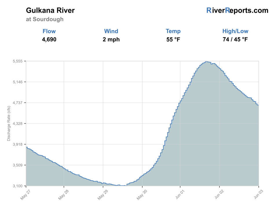
Showing the available RiverReports chart while the current structured flow series loads. Check the chart on RiverReports Opens in a new tab.
Live data is incomplete for this page, so use the linked sources before committing to the drive.
Check first: Live information is incomplete. Treat this score as a planning estimate.
Rating updatedRiver local time:
The USGS flow observation is 20 hours old. Treat the rating as a live-source check, not a current fishing call, until the gauge updates.
NWS air forecast near
RiverReports gauge
Showing the available RiverReports chart while the current structured flow series loads. Check the chart on RiverReports Opens in a new tab.
Mostly Cloudy
The National Weather Service forecast is temporarily unavailable.
RiverReports gauge: Gulkana River
Seasonal starting points, not a live hatch report. Match what you see on the water.
Each fly name opens its matching Fly Box guide.
The best Gulkana days have manageable flows, clear enough water to read structure, and rules that match your target species. If the canyon or remote float risks are above your skill level, choose a shorter walk-in section or a different river.
Best for multi-day planning when rapids, camps, and takeouts match your skill.
Better for walk-in grayling and trout tactics, but boats may scrape and fish can be spooky.
Can make the canyon and sweepers serious. Do not force a float because a salmon window is open.
Pack for exposure and be ready to change from dries to streamers or nymphs.
We could not confirm all current conditions. Check locally before choosing how to fish.
Current conditions at the exact access are not verified. No access method is recommended until they are checked.
Current conditions at the exact access are not verified. No access method is recommended until they are checked.
Current conditions at the exact access are not verified. No access method is recommended until they are checked.
Is Gulkana River worth the trip today? Check flow, weather, hatches, access, and rules for Alaska before you go.
The Gulkana is bigger and more remote than a quick roadside trout stream. It can offer grayling, rainbow trout, and seasonal salmon opportunity, but legal seasons, float skill, access fees, and water level should decide the plan before fly choice.
The USGS flow observation is 20 hours old. Treat the rating as a live-source check, not a current fishing call, until the gauge updates.
USGS shows 889 cfs. The flow has been stable over about 6 hours. USGS marks this reading provisional and may revise it. USGS records for this date (1973-2026, 37 readings) show a typical middle range of 645 cfs to 1,290 cfs. Flow is within the typical range for this date, so weather, temperature, and access become the next checks.
October to winter: Cold, short-day fishing is specialized.
USGS water temperature is about 32.7F, and the rolling 24-hour high did not trigger a heat caution. USGS marks the temperature data provisional and may revise it.
No active NWS alert was returned for this forecast point.
Stable flows that match your boat and wading skill are more important than a single ideal number.
Skip during rising water, canyon uncertainty, unresolved access fees, wildfire/smoke issues, or unclear salmon rules.
Pick either a short walk-in grayling/trout day or a fully planned float. Do not mix both without enough time.
If the Gulkana is too big or the float logistics are not ready, choose a simpler road-access grayling plan.
Use these places as starting points. Open the access link below and check posted signs before you park or enter.
Check the current Alaska Upper Copper/Upper Susitna rules and emergency orders before fishing. Salmon opportunity can change quickly, and this report does not replace current rules.
ADF&G and BLM describe this as part of the longer float plan. Confirm current logistics and conditions.
A key BLM area access and shorter-float reference point.
ADF&G lists several highway-access options, some of which may involve private land or fees.
Official agencies and primary river operators come first. Secondary tools are labeled so you know what carries the most weight.
Check what is allowed, where the rule applies, and whether the river is open.
Check the latest river reading and forecast before you leave.
Check public entry points, land rules, and seasonal access changes.
Use these links for stocking, safety, and other local details.
Check what is allowed, where the rule applies, and whether the river is open.
Open the current rules and check the river section, season, and special limits.
Open the current rules and check the river section, season, and special limits.
Open the current rules and check the river section, season, and special limits.
Check the latest river reading and forecast before you leave.
Open this page and check the latest safety advice before your trip.
Open this river reading to check the latest level, flow, and update time.
Open this river reading to check the latest level, flow, and update time.
Check public entry points, land rules, and seasonal access changes.
Open the land or access page, then check signs before you park or enter.
Use these links for stocking, safety, and other local details.
Open this page for more river information and check when it was last updated.
What was checked: This report uses official regulation, flow, weather, access, and public-source material first, then adds practical angler planning guidance without replacing current rules.
Live measurements and forecasts keep their provider timestamps. Rules, access, and trip guidance use the source-review date shown here. BlueStreamFly planning advice is editorial interpretation, not an agency notice.
First-hand experience: BlueStreamFly does not claim a first-hand visit or local field test for this report unless a real contributor is explicitly named and linked.
Both are possible, but the full river is a float-planning project. Walk-in anglers should use verified highway access and check landowner fee notes.
Grayling and rainbow trout are the safer general fly targets. Salmon require current ADF&G rule and emergency-order checks.
Use the RiverReports chart for a quick read and USGS 15200280 as the official Gulkana flow source.