RiverReports preview · current series loading
Recent flow
RiverReports gauge
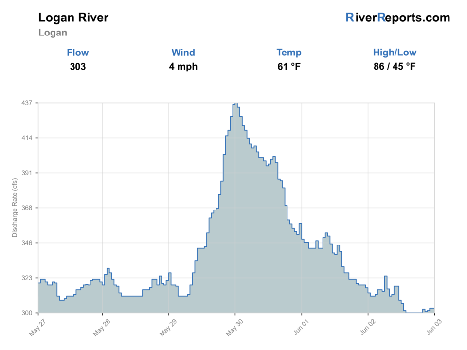
Showing the available RiverReports chart while the current structured flow series loads. Check the chart on RiverReports Opens in a new tab.
Best option: Floating. A float is in play where this report supports boat access and wind, releases, and shuttle logistics are manageable.
Rating updatedRiver local time:
This month is not listed as a top seasonal window in this page's reviewed season notes. Use current regulations, flow, temperature, and access checks before treating the score as a slam dunk.
NWS air forecast near
This is an air forecast, not a river-temperature reading. Check the water with a stream thermometer before fishing in hot weather.
RiverReports gauge
Showing the available RiverReports chart while the current structured flow series loads. Check the chart on RiverReports Opens in a new tab.
Showers And Thunderstorms
The National Weather Service forecast is temporarily unavailable.
RiverReports gauge: Logan River near Logan
Seasonal starting points, not a live hatch report. Match what you see on the water.
Also try beadhead dropper
Each fly name opens its matching Fly Box guide.
The best Logan days come after runoff settles enough to reveal clear pocket-water lanes, edges, and softer bankside shelves. If smaller streams are still surging, if the water is carrying fresh color, or if your access plan depends on wandering through posted private stretches, shorten the day or move to a clearer nearby canyon stream.
The best all-around window for pocket-water nymphing, dry-dropper coverage, and selective dry-fly shots where fish show.
Fish early, lengthen leaders, and approach soft seams from below because the easiest roadside water gets pressured quickly.
Stay on obvious edges and softer inside current, and do not assume every roadside crossing remains reasonable.
Shrink the water, fish slower buckets and tailouts, and keep expectations tied to a few productive drifts rather than covering miles.
These scores compare the risks of wading, bank fishing, and floating.
Wading is in play only where your chosen access has clear footing, legal entry, and no forced crossings.
This report does not recommend bank fishing on this reach.
A float is in play where this report supports boat access and wind, releases, and shuttle logistics are manageable.
Is Logan River worth the trip today? Check flow, weather, hatches, access, and rules for Utah before you go.
The Logan fishes best when RiverReports and USGS 10109000 show stable flow, runoff is no longer pushing every seam, and you keep the day centered on legal Highway 89 access. It is tempting to treat the whole canyon like open roadside water, but special fishing rules above Card Canyon Bridge and Utah's stream-access limits mean the cleanest trips stay tied to named public entries and conservative wading.
This month is not listed as a top seasonal window in this page's reviewed season notes. Use current regulations, flow, temperature, and access checks before treating the score as a slam dunk.
The forecast has storm or heavy-precipitation risk, so timing and access matter more than the score alone.
Float: A float is in play where this report supports boat access and wind, releases, and shuttle logistics are manageable.
USGS shows 111 cfs. The flow has been rising about 11% over about 6 hours. USGS marks this reading provisional and may revise it. USGS records for this date (1971-2026, 56 readings) show a typical middle range of 94 cfs to 162 cfs. Flow is within the typical range for this date, so weather, temperature, and access become the next checks.
The current NWS air forecast is about 52F. Showers And Thunderstorms.
Best on stable medium summer and early-fall flows that expose clear pocket-water seams without turning every crossing into a runoff problem.
Skip when smaller streams are still high and swift, the river is carrying fresh color, thunderstorm runoff is building, or your access plan depends on wandering through posted private water.
Base in Logan, choose one area such as Bridger or Preston Valley, fish it hard for a short morning or evening session, and move only if the water quality or pressure truly demands it.
Blacksmith Fork River is the cleanest nearby backup when you want a more tightly framed public canyon plan, while Weber River makes more sense if Logan is blown out or overpressured.
Use these places as starting points. Open the access link below and check posted signs before you park or enter.
On Logan River, special Utah rules apply above Card Canyon Bridge. From Card Canyon Bridge upstream to Red Banks Campground, and farther upstream to the Idaho line under the listed guidebook sections, anglers should recheck the current Utah Fishing Guidebook for the two-fish trout-and-whitefish combined limit, artificial-flies-and-lures requirements, and seasonal closure details before fishing.
A practical lower-canyon public starting point where Highway 89 access keeps a half-day trout plan simple.
A named Forest Service access zone about six miles east of Logan with direct river proximity and easy orientation.
Useful upper-canyon staging water when you want cooler flow and are ready to track the special fishing rules closely.
Official agencies and primary river operators come first. Secondary tools are labeled so you know what carries the most weight.
Check what is allowed, where the rule applies, and whether the river is open.
Check the latest river reading and forecast before you leave.
Check public entry points, land rules, and seasonal access changes.
Check what is allowed, where the rule applies, and whether the river is open.
Open the current rules and check the river section, season, and special limits.
Check the latest river reading and forecast before you leave.
Open this page and check the latest safety advice before your trip.
Open this river reading to check the latest level, flow, and update time.
Open this river reading to check the latest level, flow, and update time.
Check public entry points, land rules, and seasonal access changes.
Open the land or access page, then check signs before you park or enter.
Open the land or access page, then check signs before you park or enter.
Open the land or access page, then check signs before you park or enter.
Open the land or access page, then check signs before you park or enter.
Open the land or access page, then check signs before you park or enter.
What was checked: This report starts with official regulation, access, flow, weather, and public-water sources, then adds practical planning guidance for fly anglers.
Live measurements and forecasts keep their provider timestamps. Rules, access, and trip guidance use the source-review date shown here. BlueStreamFly planning advice is editorial interpretation, not an agency notice.
First-hand experience: BlueStreamFly does not claim a first-hand visit or local field test for this report unless a real contributor is explicitly named and linked.
Start with RiverReports for the fast chart view and keep USGS 10109000 open as the official flow backstop when you decide whether runoff has settled enough to wade safely.
Yes. Logan River has special Utah guidebook rules above Card Canyon Bridge, so check the current Utah Fishing Guidebook before you assume the standard statewide trout rules apply.
It is roadside-friendly compared with many western trout streams, but the cleanest trips still start from named public entries and respect Utah's private-bed access limits.