RiverReports preview · current series loading
Recent flow
RiverReports gauge
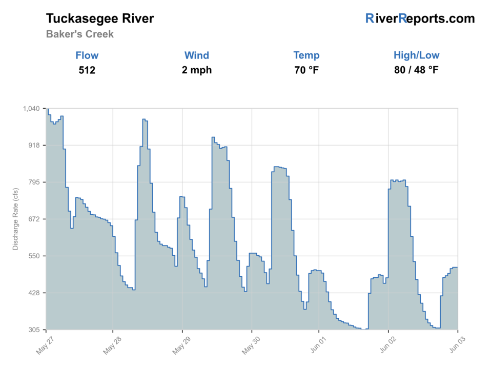
Showing the available RiverReports chart while the current structured flow series loads. Check the chart on RiverReports Opens in a new tab.
No single best way to fish. Wading and Bank fishing have the same top score. Use current access, footing, weather, and local rules to choose.
Rating updatedRiver local time:
USGS shows 177 cfs. The flow has been falling about 23% over about 6 hours. USGS marks this reading provisional and may revise it. USGS records for this date (2005-2026, 22 readings) show a median near 470 cfs and the lower quartile near 278 cfs; today's flow is below normal for the date. This is below normal, so edge depth, temperature, and pressure matter.
NWS air forecast near
This is an air forecast, not a river-temperature reading. Check the water with a stream thermometer before fishing in hot weather.
RiverReports gauge
Showing the available RiverReports chart while the current structured flow series loads. Check the chart on RiverReports Opens in a new tab.
Clear
The National Weather Service forecast is temporarily unavailable.
RiverReports gauge: Tuckasegee River near Bryson City
Seasonal starting points, not a live hatch report. Match what you see on the water.
Each fly name opens its matching Fly Box guide.
The Tuck fishes best when you match your day to the reach. Low-to-moderate steady flow gives the Webster and Dillsboro public water its best wading shape, while higher releases or runoff push the river toward heavier nymphs, streamer edges, and a more conservative access plan.
Best wading window for indicator nymphs, light streamers, and simple dry-dropper rigs.
Fish softer banks, side seams, and inside turns rather than forcing mid-river crossings.
Lengthen leaders, fish lighter indicators, and expect educated trout near easy-access pull-offs.
Start subsurface and let the warmest afternoon water drive the better dry-fly chance.
Wading and Bank fishing have the same top score. Use current access, footing, weather, and local rules to choose.
Wading is in play only where your chosen access has clear footing, legal entry, and no forced crossings.
Bank and edge fishing remains a practical low-commitment option if access is legal and footing is safe.
This report does not recommend floating this reach.
Is Tuckasegee River worth the trip today? Check flow, weather, hatches, access, and rules for North Carolina before you go.
On May 26, 2026, the most important Tuckasegee planning note is rule timing, not fly color. Webster and the Dillsboro delayed-harvest reach stay catch-and-release with single-hook artificials until the first Saturday in June, so the right move is to verify the section, check RiverReports and USGS, and fish only the water that matches the rule set in front of you.
USGS shows 177 cfs. The flow has been falling about 23% over about 6 hours. USGS marks this reading provisional and may revise it. USGS records for this date (2005-2026, 22 readings) show a median near 470 cfs and the lower quartile near 278 cfs; today's flow is below normal for the date. This is below normal, so edge depth, temperature, and pressure matter.
Fall: Cooling water and lower crowds often bring the best mix of streamer and nymph fishing.
The current NWS air forecast is about 64F, and the next 24-hour high reaches about 67F. Clear.
No active NWS alert was returned for this forecast point.
Skip or shorten the trip when rain has the river jumping, the rule date is unclear for your reach, or the bridge water is too crowded to fish cleanly.
Stable low-to-moderate flow that leaves readable seams, safe bridge entries, and enough push to move trout without turning crossings risky.
Skip or shorten the trip when rain has the river jumping, the rule date is unclear for your reach, or the bridge water is too crowded to fish cleanly.
Base in Sylva, Dillsboro, Webster, or Bryson City. Check the rule date first, then pick one public section and fish it thoroughly instead of bouncing all day.
Nantahala River, Oconaluftee River, and Davidson River offer nearby backup plans when the Tuck is high, crowded, or the rule fit is wrong.
Use these places as starting points. Open the access link below and check posted signs before you park or enter.
As of May 26, 2026, the documented delayed-harvest Tuckasegee sections stay catch-and-release with single-hook artificials until Saturday, June 6, 2026. Recheck NCWRC before fishing if your trip is near or after that date.
The NCWRC Webster Mountain Heritage map covers the Tuck from N.C. 107 bridge to Savannah Creek.
The NCWRC Dillsboro map covers the Tuck from Savannah Creek to the falls above U.S. 23-441.
Use the gauge and public pull-offs carefully. Lower-valley water gets broader and stronger than the urban trout sections upstream.
Official agencies and primary river operators come first. Secondary tools are labeled so you know what carries the most weight.
Check what is allowed, where the rule applies, and whether the river is open.
Check the latest river reading and forecast before you leave.
Check public entry points, land rules, and seasonal access changes.
Use these links for stocking, safety, and other local details.
Check what is allowed, where the rule applies, and whether the river is open.
Open the current rules and check the river section, season, and special limits.
Open the current rules and check the river section, season, and special limits.
Open the current rules and check the river section, season, and special limits.
Open the current rules and check the river section, season, and special limits.
Check the latest river reading and forecast before you leave.
Open this page and check the latest safety advice before your trip.
Open this river reading to check the latest level, flow, and update time.
Open this river reading to check the latest level, flow, and update time.
Open this river reading to check the latest level, flow, and update time.
Check public entry points, land rules, and seasonal access changes.
Open the land or access page, then check signs before you park or enter.
Open the land or access page, then check signs before you park or enter.
Use these links for stocking, safety, and other local details.
Open this page for more river information and check when it was last updated.
Open this page for more river information and check when it was last updated.
What was checked: This report starts with official regulation, access, flow, weather, and public-land sources, then adds practical planning guidance for fly anglers.
Live measurements and forecasts keep their provider timestamps. Rules, access, and trip guidance use the source-review date shown here. BlueStreamFly planning advice is editorial interpretation, not an agency notice.
First-hand experience: BlueStreamFly does not claim a first-hand visit or local field test for this report unless a real contributor is explicitly named and linked.
Not on the documented delayed-harvest Webster and Dillsboro sections as of May 26, 2026. Those sections remain catch-and-release until Saturday, June 6, 2026, then shift to youth-only until noon and open harvest after noon.
Use RiverReports for the quick chart, then back it with USGS near Bryson City and Cullowhee so you know whether the whole area is trending fishable or rising.
Yes, if you stay on the well-known public sections, respect the delayed-harvest rules, and avoid forcing wades when flow is up.