Wade, bank, and floatLimited data
Use the live sources and what you see at the river before choosing an approach.
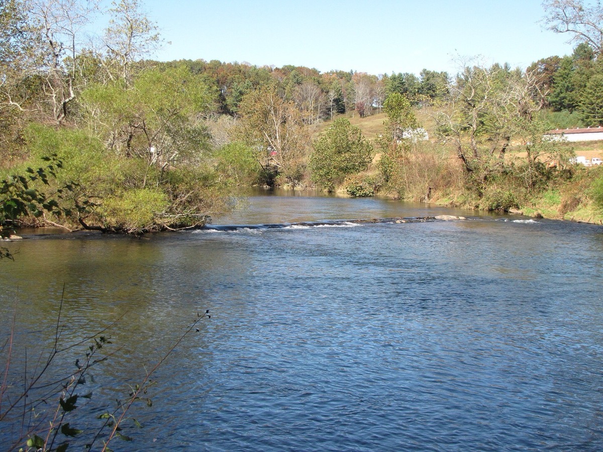
Fly fishing report · Southeast
A North Carolina New River report focused on mountain smallmouth water, South Fork flows, state park access, warmwater tactics, and trout-reach cautions.
Check flow & weatherCurrent USGS flow is 1,520 cfs. It has risen about 49% over the past 6 hours. Today's flow is above the usual high-water marker for this date; the seasonal median is 259 cfs. Treat this as high-water fishing: wading, clarity, crossings, and boat control need a conservative check.
There is not enough reliable current information to recommend wading, bank fishing, or floating.
Use the live sources and what you see at the river before choosing an approach.
Check before you drive
Look at whether the river is rising or falling, then check wind, rain, and storms. These can change both safety and fishing.
Before you rely on this report
Conditions can change quickly. Check these dates before you decide to fish, and open the official source when safety or rules matter.
High confidence in the current score inputs.
7 sources are listed below for you to open.
3 public access records are listed. Private spots are never shown.
Source checked Jul 30, 2026
Plan your access
These are public parking, launch, trail, or recreation areas—not secret fishing spots. We never show an angler's private pins, notes, or photos here.
Public land
Primary public access and float-planning resource.
State park access is useful, but many banks outside public areas are private.
The river can look shallow while still hiding slick ledges and drop-offs.
Area description
Primary gauge context and mountain smallmouth planning area.
State park access is useful, but many banks outside public areas are private.
The river can look shallow while still hiding slick ledges and drop-offs.
Area description
Use NC Wildlife resources before treating any fork as trout water.
State park access is useful, but many banks outside public areas are private.
The river can look shallow while still hiding slick ledges and drop-offs.
How to fish it
The New River in North Carolina is best handled as a smallmouth and float-fishing report, with trout notes for managed fork-specific reaches rather than a generic trout promise.
USGS shows 1,520 cfs with a rising about 49% over about 6 hours trend. Today's flow is above the usual high-water marker for this date; the seasonal median is 259 cfs. Treat this as high-water fishing: wading, clarity, crossings, and boat control need a conservative check.
The forecast has storm or heavy-precipitation risk, so timing and access matter more than the score alone.
A Flood Watch is active near this forecast point, so the score is capped until runoff, clarity, crossings, and road access are checked. NWS alert: Flood Watch issued August 2 at 5:48PM EDT until August 3 at 2:00AM EDT by NWS Blacksburg VA.
Summer: Poppers, sliders, terrestrials, and wet-wading trips define the main season.
The NWS forecast is about 70F with Showers And Thunderstorms Likely.
Read the water
The New fishes best for fly anglers when flows are stable enough to wade or float safely and smallmouth can use ledges, banks, and current breaks.
Wade carefully, fish shade and depth, and use stealth near clear ledges.
Best mix of streamer, popper, and float-fishing options.
Avoid wading ledges and wait for visibility or fish bank seams from safe access.
Fish early or late and handle bass quickly in warm water.
Your trip plan
Use USGS 03161000 on the South Fork near Jefferson as the main mountain New River trend, then match it to your access, ledge depth, float distance, and storm forecast.
Skip wading or floating when storms are building, the South Fork is high or muddy, ledges are slick and pushy, or your takeout and public-bank plan are not confirmed.
Start with the South Fork gauge and New River State Park access. Pick a short wade or real float plan, then rig poppers, crayfish, and baitfish patterns around shade and ledges.
If the New River is too high, stormy, or crowded, compare Davidson or Nantahala for trout plans, or larger southern tailwaters when you want more flow control.
Hatches & flies
 Fly pattern · report suggests “Small Clouser”Clouser Deep MinnowThe reviewed chartreuse-and-white form uses sparse layered bucktail with flash around lead barbell eyes. The eyes make the fly sink between strips and ride hook point up; color, eye weight, hook, and saltwater materials must remain labeled.See photos & how to fish it ↗
 Fly pattern · report suggests “woolly bugger”Woolly BuggerThe shared pattern language is a marabou tail, chenille or dubbed body, and palmered hackle. Bead heads, dumbbell eyes, flash, rubber tails, colors, and body materials materially change the tied variation and must be labeled.See photos & how to fish it ↗+ 2 more reviewed guides in the Fly Box Fly pattern · report suggests “Clouser”Clouser Deep MinnowThe reviewed chartreuse-and-white form uses sparse layered bucktail with flash around lead barbell eyes. The eyes make the fly sink between strips and ride hook point up; color, eye weight, hook, and saltwater materials must remain labeled.See photos & how to fish it ↗
 Fly family · report suggests “crayfish”Crayfish and Crawfish PatternsCrayfish patterns differ in claw size, eye placement, shell profile, leg motion, weighting, hook orientation, and snag resistance. Rust, brown, olive, tan, and pale molting colors remain labeled choices rather than aliases for one recipe.See family guide ↗+ 3 more reviewed guides in the Fly Box
  Fly family · report suggests “Poppers”Bass and Panfish Popper PatternsPoppers may use cupped foam, cork, balsa, deer hair, or pencil-shaped heads. Head face, size, buoyancy, tail, legs, and weed guard determine sound and action; a generic popper label does not identify one fly.See family guide ↗
 Fly family · report suggests “sliders”Warmwater Slider and Diver PatternsA slider has a tapered, flat, or softly shaped head that glides or pushes a small wake with limited noise. A diver has an angled, collared, folded, or otherwise shaped head that pulls below the surface when stripped and rises on the pause. Frog, baitfish, and large-insect profiles can be tied on either idea, so the exact head action, buoyancy, hook orientation, weed guard, and material must stay named.See family guide ↗+ 3 more reviewed guides in the Fly Box
  Fly family · report suggests “Sculpin”Sculpin PatternsSculpin flies may use muddler heads, cones, dumbbells, jigs, or soft materials. The broad-head, bottom-hugging profile defines the family—not one exact construction.See family guide ↗Fly pattern · report suggests “Clouser”Clouser Deep MinnowThe reviewed chartreuse-and-white form uses sparse layered bucktail with flash around lead barbell eyes. The eyes make the fly sink between strips and ride hook point up; color, eye weight, hook, and saltwater materials must remain labeled.See photos & how to fish it ↗+ 3 more reviewed guides in the Fly Box
 Fish ledge drops, boulder shade, and the soft side of current tongues.
Use crayfish patterns near bottom when fish are not chasing.
Throw poppers early, late, and around shaded banks in warm stable water.
Float only with a real shuttle and takeout plan.
Treat trout reaches as separate legal water and verify the rules before fishing them.
Rules & closures
Open the agency page to confirm the exact river section, species, season, tackle rules, limits, and emergency closures.
Official links checkedWe checked the state source but did not find a clearly supported exception for this river. Check the official rules for the exact section you plan to fish.
This summary helps with trip planning. The linked agency rule is the one you must follow.
Updates from anglers
Recent observations from general areas of New River. We review every update before it appears and never publish exact fishing spots, private access details, or photo locations.
You can still use the river plan above. Check back later for recent observations from other anglers.
Where this report comes from
Fishing guidance checked: Jun 1, 2026
Site check: Jul 14, 2026. We regularly test report links, live scores, flow and weather data, and page loading. The content date changes only when the fishing guidance or its sources change.
Common questions
Check South Fork flow, state park access, weather, float logistics, and NC Wildlife rules for any trout-specific reach.
Smallmouth rules and general inland rules apply to the main warmwater plan; trout rules are fork-specific.
Yes at suitable flows, but shallow ledges, storms, and private banks require caution.
Bring the seasonal hatch box, a nymph box, a few streamers, and a backup plan for clear, high, warm, or crowded water.