Wade · Best fit49/100
Wading is the most sensitive plan today. Use protected edges only, avoid crossings, and downgrade quickly if clarity or current feels wrong.
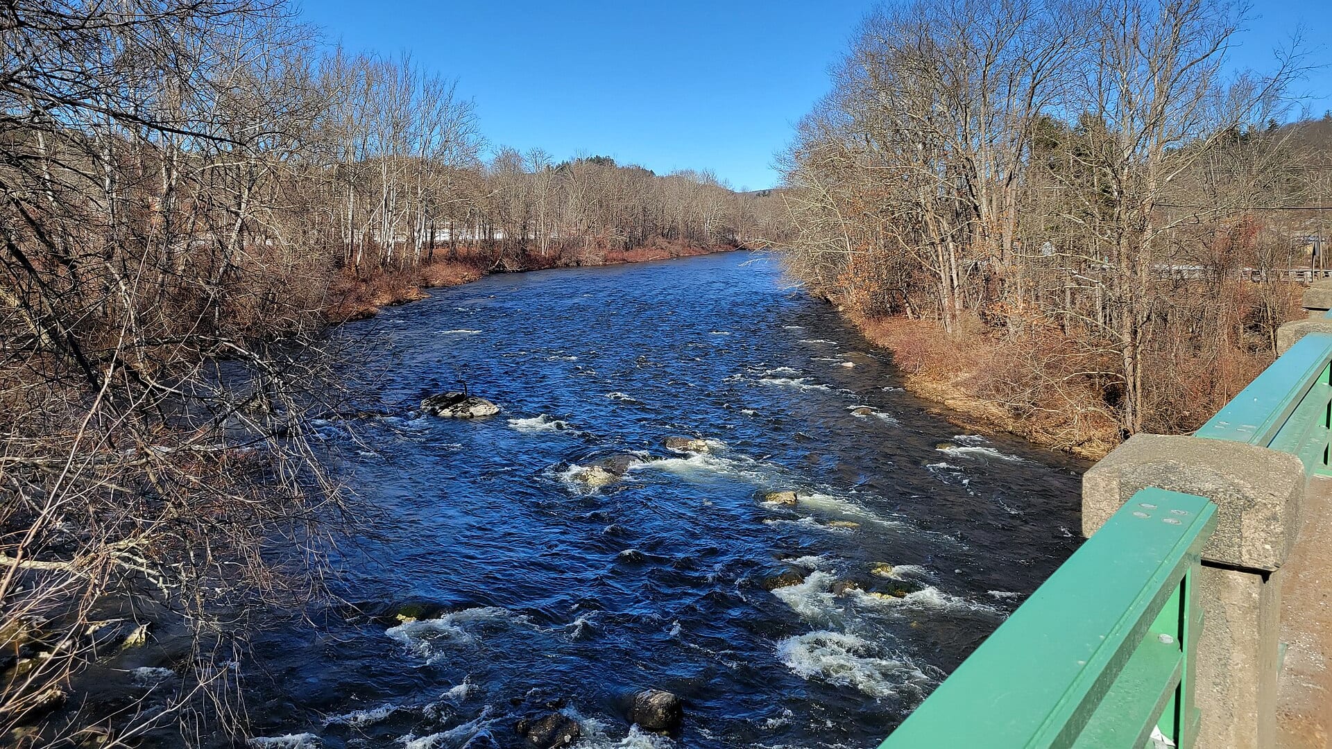
Fly fishing report · Northeast
A Westfield River report for western Massachusetts freestone trout, East Branch access, catch-and-release rules, flow checks, hatches, and safety.
Check flow & weatherCurrent USGS flow is 88 cfs and has been stable for about 6 hours. Today's flow is high for this date; the upper end of the normal range is near 63 cfs. Fishable water may exist, but do not rate it highly without a safe access, clarity, and wading or boat plan.
Compare wading, bank fishing, and floating before choosing how you will fish.
Wading is the most sensitive plan today. Use protected edges only, avoid crossings, and downgrade quickly if clarity or current feels wrong.
This report does not describe this as a primary mode. Verify legal access, depth, launches, and retreat options before planning around it.
This report does not describe this as a primary mode. Verify legal access, depth, launches, and retreat options before planning around it.
Check before you drive
Look at whether the river is rising or falling, then check wind, rain, and storms. These can change both safety and fishing.
Before you rely on this report
Conditions can change quickly. Check these dates before you decide to fish, and open the official source when safety or rules matter.
High confidence in the current score inputs.
6 sources are listed below for you to open.
3 public access records are listed. Private spots are never shown.
Source checked Jul 30, 2026
Plan your access
These are public parking, launch, trail, or recreation areas—not secret fishing spots. We never show an angler's private pins, notes, or photos here.
Area description
Use the MassWildlife PDF for boundaries and rules before fishing.
Many good-looking pullouts are close to private land. Use official WMA, state-park, and posted public access.
Storms can make this river rise quickly. If the water is changing color or climbing, leave crossings alone.
Area description
Important public coldwater habitat with WMA regulations and rugged access.
Many good-looking pullouts are close to private land. Use official WMA, state-park, and posted public access.
Storms can make this river rise quickly. If the water is changing color or climbing, leave crossings alone.
Day use
A practical family-access and picnic base on the East Branch corridor.
Many good-looking pullouts are close to private land. Use official WMA, state-park, and posted public access.
Storms can make this river rise quickly. If the water is changing color or climbing, leave crossings alone.
How to fish it
The Westfield is a branch-based freestone system. Good fishing starts with the Huntington gauge, then narrows by branch, special-rule section, temperature, and access.
USGS shows 88 cfs with a stable over about 6 hours trend. Today's flow is high for this date; the upper end of the normal range is near 63 cfs. Fishable water may exist, but do not rate it highly without a safe access, clarity, and wading or boat plan.
Wade: Wading is the most sensitive plan today. Use protected edges only, avoid crossings, and downgrade quickly if clarity or current feels wrong.
Early summer: Caddis, terrestrials, and evening dry-fly windows can be good before heat builds.
The NWS forecast is about 70F with Chance Rain Showers.
No active NWS alert was returned for this forecast point.
Read the water
The Westfield rewards anglers who treat it like a mountain freestone: watch rain, avoid pushy crossings, fish pocket water when the river is stable, and use smaller flies when it drops clear.
Fish pocket water, riffle edges, and pool heads with dry-droppers or nymphs.
Stay near banks, use streamers only where safe, and skip crossings.
Use longer leaders, smaller dries, soft hackles, and low-profile approaches.
Check temperature before targeting trout and consider bass water or waiting for cooler conditions.
Your trip plan
Use USGS 01181000 at Huntington as a West Branch trend, not a perfect reading for every East Branch or upper tributary reach. Pair it with rainfall, clarity, and branch-specific access.
Skip wading when the river is rising, stained enough to hide boulders, too warm for trout handling, or when the East Branch special-rule boundary is not clear.
Start with the Huntington gauge and MassWildlife catch-and-release map, then pick one public access corridor such as the East Branch, Upper Westfield WMA, or C.M. Gardner area.
If the Westfield is too high, warm, or crowded, compare the Swift River, Millers River, or Housatonic River before forcing freestone trout water.
Hatches & flies
 Fly pattern · report suggests “Zebra midge”Zebra MidgeLook for a very slim tapered thread body, evenly spaced contrasting wire rib, a small bead, and no tail or wing. The reviewed classic is black with silver wire and a silver bead. Red, olive, brown, glass-bead, jig-hook, resin-coated, or tailed forms must remain labeled variations rather than replacing the classic identity.See photos & how to fish it ↗
 Fly family · report suggests “black stonefly nymph”Black Stonefly PatternsBlack stonefly wording is a color and insect-group label, not one exact recipe. Size, nymph versus adult stage, wing profile, and weighting must remain explicit.See family guide ↗+ 2 more reviewed guides in the Fly Box
  Fly family · report suggests “Hendrickson”Hendrickson PatternsHendrickson is a hatch name. Nymphs and emergers, upright or low-riding duns, and rusty spent spinners are different fly jobs.See family guide ↗
 Fly pattern · report suggests “elk hair caddis”Elk Hair CaddisLook for a tented elk- or deer-hair wing, clipped hair head, dubbed body, rib, and hackle palmered along the body. The body color should be labeled because tiers often match different natural caddis colors.See photos & how to fish it ↗+ 2 more reviewed guides in the Fly Box
  Fly pattern · report suggests “X-caddis”X-CaddisIdentify the X-Caddis by the combination of a sparse translucent Zelon-style trailing shuck, slim dubbed body, tented deer- or elk-hair wing, small clipped head, and no palmered body hackle. The separately photographed Elk Hair Caddis has a higher, hackled adult footprint and no defining trailing shuck. The natural-adult photograph explains the caddis tent-wing silhouette, but it does not turn the X-Caddis into an exact adult-species imitation.See photos & how to fish it ↗
 Fly pattern · report suggests “parachute Adams”Parachute AdamsThe upright light post and horizontal parachute hackle are the defining visual cues. The classic pilot example uses a gray-brown body and divided tail, but color and size variations should be labeled instead of treated as identical.See photos & how to fish it ↗+ 2 more reviewed guides in the Fly Box
  Fly family · report suggests “BWO dry”Blue-Winged Olive PatternsBWO describes a hatch group, not one fly. Nymph, emerger, dry, cripple, and spinner profiles must stay separate because they occupy different parts of the water column.See family guide ↗
 Fly family · report suggests “midge emerger”Midge Patterns by StageMidge wording can mean a threadlike larva, wing-padded pupa, film emerger, tiny adult, or visible cluster. Those profiles fish at different depths.See family guide ↗+ 3 more reviewed guides in the Fly Box
 Treat each branch as a different stream; the gauge is context, not permission to wade everywhere.
Fish pocket water with a buoyant dry and a small tungsten dropper when flows are moderate.
Swing soft hackles through tailouts during caddis and olive activity.
Use small streamers along undercut banks after rain, but stay out of heavy mid-channel current.
In summer, carry a thermometer and stop trout fishing when handling becomes risky.
Rules & closures
Open the agency page to confirm the exact river section, species, season, tackle rules, limits, and emergency closures.
Official links checkedWe checked the state source but did not find a clearly supported exception for this river. Check the official rules for the exact section you plan to fish.
This summary helps with trip planning. The linked agency rule is the one you must follow.
Updates from anglers
Recent observations from general areas of Westfield River. We review every update before it appears and never publish exact fishing spots, private access details, or photo locations.
You can still use the river plan above. Check back later for recent observations from other anglers.
Where this report comes from
Fishing guidance checked: May 31, 2026
Site check: Jul 14, 2026. We regularly test report links, live scores, flow and weather data, and page loading. The content date changes only when the fishing guidance or its sources change.
Common questions
Check the Huntington USGS gauge, branch-specific weather, and MassWildlife special-area map before picking a reach.
Yes. The East Branch catch-and-release area has mapped special rules and should be checked directly.
Yes, but only if you match the reach, season, water temperature, and target species. This page separates trout, migratory, and warmwater plans where that matters.
Bring the hatch-chart flies, a few confidence nymphs, and a backup streamer or warmwater box so you can adjust to flow, clarity, and temperature.
Access is good in public areas but not continuous. Use WMA, state-park, and legal roadside access only.