RiverReports preview · current series loading
Recent flow
RiverReports gauge
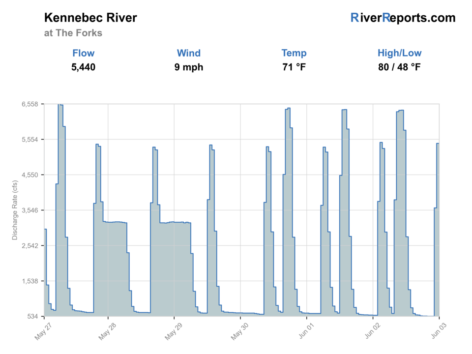
Showing the available RiverReports chart while the current structured flow series loads. Check the chart on RiverReports Opens in a new tab.
Best option: Floating. A float is in play where this report supports boat access and wind, releases, and shuttle logistics are manageable.
Rating updatedRiver local time:
USGS shows 466 cfs. The flow has been stable over about 6 hours. USGS marks this reading provisional and may revise it. USGS records for this date (1904-2026, 123 readings) show a median near 1,660 cfs and a low-water marker near 912 cfs; today's flow is unusually low for the date. Low water can make fish spooky, warm, pressured, or concentrated; check temperature and handling risk.
NWS air forecast near
This is an air forecast, not a river-temperature reading. Check the water with a stream thermometer before fishing in hot weather.
RiverReports gauge
Showing the available RiverReports chart while the current structured flow series loads. Check the chart on RiverReports Opens in a new tab.
Partly Sunny
The National Weather Service forecast is temporarily unavailable.
RiverReports gauge: Kennebec River at The Forks
Seasonal starting points, not a live hatch report. Match what you see on the water.
Each fly name opens its matching Fly Box guide.
The best days come when release volume, weather, and your chosen access method agree. Cool spring and fall windows are often the clearest fishing calls, while heavy rafting releases or unsafe wading conditions should push the reach into float-only or no-go territory.
Best for structured drift fishing, safe edge wading, and fishing obvious seams instead of brute-force current.
Usually a float or no-go decision rather than a wade plan.
Often the best mix of temperature and fish movement, but always confirm the current fall rules first.
Still better than many rivers because the water is cold, but glare and release pace can make the fishing feel smaller than the river looks.
These scores compare the risks of wading, bank fishing, and floating.
This report does not recommend wading on this reach.
This report does not recommend bank fishing on this reach.
A float is in play where this report supports boat access and wind, releases, and shuttle logistics are manageable.
Is Kennebec River worth the trip today? Check flow, weather, hatches, access, and rules for the area at the Forks, Maine before you go.
The Forks section is useful when scheduled releases and current flow leave defined bank water, manageable wading margins, or a clear drift plan. It is a poor place to improvise once the river is running like a rafting area instead of a fishing river.
USGS shows 466 cfs. The flow has been stable over about 6 hours. USGS marks this reading provisional and may revise it. USGS records for this date (1904-2026, 123 readings) show a median near 1,660 cfs and a low-water marker near 912 cfs; today's flow is unusually low for the date. Low water can make fish spooky, warm, pressured, or concentrated; check temperature and handling risk.
Float: A float is in play where this report supports boat access and wind, releases, and shuttle logistics are manageable.
Late fall: Useful for release-only windows, but cold weather and flow discipline matter.
The current NWS air forecast is about 51F, and the next 24-hour high reaches about 57F. Partly Sunny.
No active NWS alert was returned for this forecast point.
Release levels that leave defined bank structure and manageable edge water instead of wall-to-wall push.
Skip when the river is too heavy for safe edge fishing, when rafting traffic dominates your window, or when access does not match your day style.
Check the release picture first, pick either Harris Station or the lower The Forks side, fish one clear access plan, and leave if the river is bigger than your margin.
The Dead River or a smaller trout-and-salmon plan is the better pivot if the Kennebec is running too hard for your objective.
Use these places as starting points. Open the access link below and check posted signs before you park or enter.
Check Maine's current special-law page before fishing. Nearby upper Kennebec and Dead River sections around The Forks use artificial-lures-only rules, two-fish brook-trout limits, and seasonal fall release-only windows that must be matched to the exact reach.
Maine notes the staircase at Harris Station as recreational access to the Kennebec River.
The lower reach near the confluence area gives anglers a practical public reference point when the upper river is too heavy.
The management plan identifies Route 201 as the main road-access spine for this region.
Official agencies and primary river operators come first. Secondary tools are labeled so you know what carries the most weight.
Check what is allowed, where the rule applies, and whether the river is open.
Check the latest river reading and forecast before you leave.
Check public entry points, land rules, and seasonal access changes.
Check what is allowed, where the rule applies, and whether the river is open.
Open the current rules and check the river section, season, and special limits.
Check the latest river reading and forecast before you leave.
Open this page and check the latest safety advice before your trip.
Open this river reading to check the latest level, flow, and update time.
Open this river reading to check the latest level, flow, and update time.
Check public entry points, land rules, and seasonal access changes.
Open the land or access page, then check signs before you park or enter.
Open the land or access page, then check signs before you park or enter.
What was checked: This report uses official regulation, flow, weather, access, and public-land sources first, then adds practical planning guidance for fly anglers.
Live measurements and forecasts keep their provider timestamps. Rules, access, and trip guidance use the source-review date shown here. BlueStreamFly planning advice is editorial interpretation, not an agency notice.
First-hand experience: BlueStreamFly does not claim a first-hand visit or local field test for this report unless a real contributor is explicitly named and linked.
Check RiverReports and USGS 01042500 first, because the release-driven flow tells you whether the day is really wadeable or should be treated as a float-only or no-go plan.
Not usually. It is a big cold release river, and beginner anglers are better off choosing safer, smaller water unless flows are especially forgiving.
Start with Harris Station or The Forks access context and use Route 201 for scouting instead of improvising entries.