Wade · Best fit66/100
Wading is in play only where your chosen access has clear footing, legal entry, and no forced crossings.
Fly fishing report · West
A source-checked Gunnison Gorge report for Black Canyon and Gunnison Gorge planning, with flows, access difficulty, hatches, flies, and safety notes.
Check flow & weatherCurrent USGS flow is 244 cfs and has been stable for about 6 hours. Today's flow is below the normal seasonal range, which begins near 328 cfs. This is below normal, so edge depth, temperature, and pressure matter.
Compare wading, bank fishing, and floating before choosing how you will fish.
Wading is in play only where your chosen access has clear footing, legal entry, and no forced crossings.
This report does not describe this as a primary mode. Verify legal access, depth, launches, and retreat options before planning around it.
This report does not describe this as a primary mode. Verify legal access, depth, launches, and retreat options before planning around it.
Check before you drive
Look at whether the river is rising or falling, then check wind, rain, and storms. These can change both safety and fishing.
Before you rely on this report
Conditions can change quickly. Check these dates before you decide to fish, and open the official source when safety or rules matter.
High confidence in the current score inputs.
6 sources are listed below for you to open.
3 public access records are listed. Private spots are never shown.
Source checked Jul 30, 2026
Plan your access
These are public parking, launch, trail, or recreation areas—not secret fishing spots. We never show an angler's private pins, notes, or photos here.
Roadside access
The easiest park river access when the steep road is open; NPS notes restrictions and winter closure.
NPS says East Portal Road is steep, has hairpin turns, restricts longer vehicles, and closes in winter.
BLM day-use and camping fees can apply in Gunnison Gorge Wilderness.
Area description
Very difficult NPS routes for fit, prepared anglers with realistic time and safety margins.
NPS says East Portal Road is steep, has hairpin turns, restricts longer vehicles, and closes in winter.
BLM day-use and camping fees can apply in Gunnison Gorge Wilderness.
Public land
BLM-managed downstream wilderness access with permit, fee, route, and float-planning considerations.
NPS says East Portal Road is steep, has hairpin turns, restricts longer vehicles, and closes in winter.
BLM day-use and camping fees can apply in Gunnison Gorge Wilderness.
How to fish it
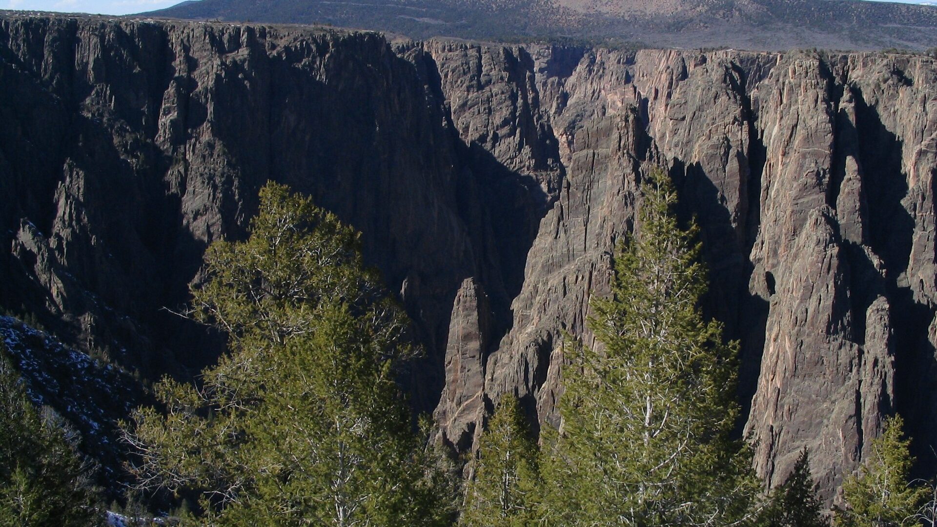
The Gunnison Gorge can offer excellent trout fishing, but access and safety are the first filters. The river is remote, steep, and regulation-sensitive, so build the plan around verified flows and official land-manager guidance.
USGS shows 244 cfs with a stable over about 6 hours trend. Today's flow is below the normal seasonal range, which begins near 328 cfs. This is below normal, so edge depth, temperature, and pressure matter.
The NWS forecast is near 94F. Fish early and verify water temperature where trout stress is possible.
Wade: Wading is in play only where your chosen access has clear footing, legal entry, and no forced crossings.
Summer: Early starts, canyon heat planning, caddis, mayflies, and terrestrial patterns can matter.
No active NWS alert was returned for this forecast point.
Read the water
Fish the Gorge only when flow, weather, access, and your group's fitness line up. When conditions are right, nymphs, dries, and streamers can all produce, but safe travel and current rules matter more than forcing a fishing window.
Use lighter nymph rigs, longer leaders, and careful approaches in slick, technical pools.
This is the most flexible fishing window for nymphs, soft hackles, dries, and streamers.
Reconsider wading and route choice. Canyon water can become dangerous quickly with limited escape options.
Plan early starts, carry extra water, and avoid overcommitting to exposed canyon hikes.
Your trip plan
Use the RiverReports Gunnison Tunnel chart and USGS 09128000 together. Stable releases are the cleanest planning signal; sudden changes, high pushy water, or flows that erase safe edge water should move you to a different reach or a different day.
Skip the Gorge when you are not prepared for the hike or float logistics, when heat or thunderstorms raise canyon risk, when NPS or BLM rules are unclear for the exact water you plan to fish, or when release changes make safe wading unrealistic.
Choose the access style first: East Portal and park context for a shorter controlled plan, or BLM Gunnison Gorge routes only when the group is ready for steep travel, limited shade, and a full exit commitment.
If the Gorge is too hot, too high, too stormy, or too logistically heavy, compare the Lower Gunnison for easier valley context, the Upper Gunnison for a different basin plan, or the Cimarron River for smaller high-country water after checking current rules.
Hatches & flies
 Fly pattern · report suggests “Zebra midge”Zebra MidgeLook for a very slim tapered thread body, evenly spaced contrasting wire rib, a small bead, and no tail or wing. The reviewed classic is black with silver wire and a silver bead. Red, olive, brown, glass-bead, jig-hook, resin-coated, or tailed forms must remain labeled variations rather than replacing the classic identity.See photos & how to fish it ↗
 Fly pattern · report suggests “RS2”RS2Start with the beadless architecture: two dark-dun Microfibett tails separated behind a slim, tightly twisted and visibly segmented dubbed abdomen; a fuller thorax; and saddle-hackle web clipped into a short angled wing bud. Rim Chung's original-style form uses natural beaver dubbing and hackle web. CDC- or Antron-wing ties, beads, curved hooks, flash, and tailless Avatar-style flies must remain labeled variations.See photos & how to fish it ↗+ 2 more reviewed guides in the Fly Box
  Fly family · report suggests “BWO emerger”Blue-Winged Olive PatternsBWO describes a hatch group, not one fly. Nymph, emerger, dry, cripple, and spinner profiles must stay separate because they occupy different parts of the water column.See family guide ↗
 Fly family · report suggests “caddis pupa”Caddis Pupa PatternsCaddis pupa is a life-stage family. Curved bodies, wing pads, legs, beads, and soft-hackle collars differ among exact patterns and must be labeled.See family guide ↗+ 2 more reviewed guides in the Fly Box
  Fly pattern · report suggests “Elk hair caddis”Elk Hair CaddisLook for a tented elk- or deer-hair wing, clipped hair head, dubbed body, rib, and hackle palmered along the body. The body color should be labeled because tiers often match different natural caddis colors.See photos & how to fish it ↗
 Fly family · report suggests “PMD”Pale Morning Dun PatternsPMD names an insect group, not one fly. Pale nymphs, trailing-shuck emergers, upright or low-riding duns, cripples, and spent-wing spinners stay visibly separate.See family guide ↗+ 3 more reviewed guides in the Fly Box Fly family · report suggests “BWO dry”Blue-Winged Olive PatternsBWO describes a hatch group, not one fly. Nymph, emerger, dry, cripple, and spinner profiles must stay separate because they occupy different parts of the water column.See family guide ↗Fly pattern · report suggests “zebra midge”Zebra MidgeLook for a very slim tapered thread body, evenly spaced contrasting wire rib, a small bead, and no tail or wing. The reviewed classic is black with silver wire and a silver bead. Red, olive, brown, glass-bead, jig-hook, resin-coated, or tailed forms must remain labeled variations rather than replacing the classic identity.See photos & how to fish it ↗+ 2 more reviewed guides in the Fly Box
 Decide whether the day is a hike-in, East Portal, or float-supported plan before choosing gear.
Keep nymph rigs simple enough to re-tie on rock shelves and windy banks.
Fish the near edge thoroughly before wading into canyon current.
Carry more water and emergency margin than a roadside trout day would require.
Do not continue downstream without a realistic exit plan.
Rules & closures
Open the agency page to confirm the exact river section, species, season, tackle rules, limits, and emergency closures.
Official links checkedSpecial regulation
This summary helps with trip planning. The linked agency rule is the one you must follow.
Updates from anglers
Recent observations from general areas of Gunnison Gorge of the Black Canyon. We review every update before it appears and never publish exact fishing spots, private access details, or photo locations.
You can still use the river plan above. Check back later for recent observations from other anglers.
Where this report comes from
Fishing guidance checked: May 31, 2026
Site check: Jul 14, 2026. We regularly test report links, live scores, flow and weather data, and page loading. The content date changes only when the fishing guidance or its sources change.
Common questions
No. Some access, especially inner-canyon and wilderness routes, is steep, remote, and physically demanding.
Use RiverReports and USGS 09128000 below the Gunnison Tunnel as the primary canyon flow reference.
Rules depend on the exact reach. NPS lists catch-and-release for rainbows and specific brown trout rules in its park reach, so verify current regulations before fishing.
Bring midges, BWOs, caddis, stonefly nymphs, PMDs, terrestrials, dry-droppers, and streamers.