RiverReports preview · current series loading
Recent flow
RiverReports gauge
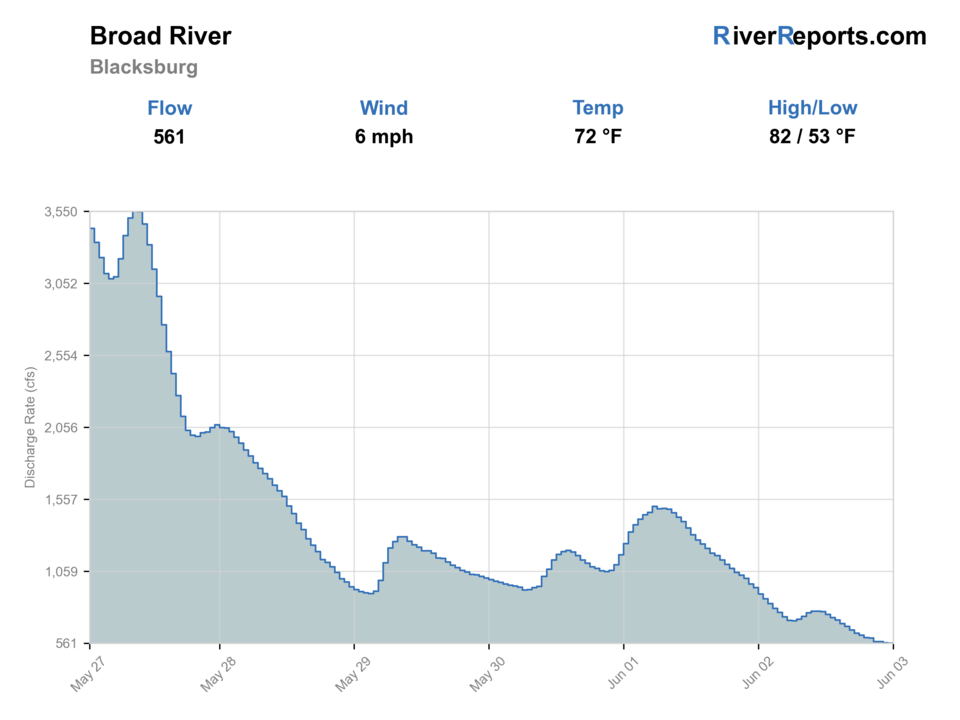
Showing the available RiverReports chart while the current structured flow series loads. Check the chart on RiverReports Opens in a new tab.
No single best way to fish. Wading, Bank fishing, and Floating have the same top score. Use current access, footing, weather, and local rules to choose.
Rating updatedRiver local time:
USGS shows 790 cfs. The flow has been falling about 17% over about 6 hours. USGS marks this reading provisional and may revise it. USGS records for this date (1998-2026, 29 readings) show a typical middle range of 605 cfs to 1,130 cfs. Flow is within the typical range for this date, so weather, temperature, and access become the next checks.
NWS air forecast near
This is an air forecast, not a river-temperature reading.
RiverReports gauge
Showing the available RiverReports chart while the current structured flow series loads. Check the chart on RiverReports Opens in a new tab.
Sunny
The National Weather Service forecast is temporarily unavailable.
RiverReports gauge: Broad River near Blacksburg
Seasonal starting points, not a live hatch report. Match what you see on the water.
Also try crawdad fly
Each fly name opens its matching Fly Box guide.
The Broad is strongest for fly anglers when flows are stable enough to read current tongues around the shoals and low enough that your take-out plan still feels simple. Rising water, release noise near the dam, or muddy current should push you toward a short bank session at the tailrace or a full skip.
Best for reading shoals, floating between public launches, and stripping streamers through defined current lanes.
Good for careful wading and lighter flies, but stay honest about exposed rock, spooky fish, and longer walks between productive lies.
Treat as a major caution near the dam and anywhere current starts filling the shoals. Shorten the session or move off the water.
Best skipped unless you are already committed to a safe float plan with the right boat control and local familiarity.
Wading, Bank fishing, and Floating have the same top score. Use current access, footing, weather, and local rules to choose.
Wading is in play only where your chosen access has clear footing, legal entry, and no forced crossings.
Bank and edge fishing remains a practical low-commitment option if access is legal and footing is safe.
A float is in play where this report supports boat access and wind, releases, and shuttle logistics are manageable.
Is Broad River worth the trip today? Check flow, weather, hatches, access, and rules for South Carolina before you go.
The safest publishable Broad River plan is the South Carolina scenic segment below Ninety-Nine Islands Dam. Start with RiverReports and USGS 02153200, launch only from the named SCDNR access points, and let current, release signals, and your comfort in rocky shoals decide whether the day is a short bank session or a committed float.
USGS shows 790 cfs. The flow has been falling about 17% over about 6 hours. USGS marks this reading provisional and may revise it. USGS records for this date (1998-2026, 29 readings) show a typical middle range of 605 cfs to 1,130 cfs. Flow is within the typical range for this date, so weather, temperature, and access become the next checks.
Fall: A reliable time for stable water, aggressive bass, and fewer recreational users on the scenic corridor.
The current NWS air forecast is about 56F, and the next 24-hour high reaches about 72F. Sunny.
No active NWS alert was returned for this forecast point.
Skip when the river is rising, muddy, pushy over shoals, too hot, release-affected, or the put-in/takeout plan is not confirmed.
Use the Blacksburg trend with water color and shoal safety. Stable or slowly falling water is the cleanest warmwater signal.
Skip when the river is rising, muddy, pushy over shoals, too hot, release-affected, or the put-in/takeout plan is not confirmed.
Start with the Blacksburg gauge, then choose Ninety-Nine Islands or a planned landing before picking flies.
Compare Lower Saluda River, North Saluda River, or Catawba options when the Broad is high, muddy, hot, or shuttle-limited.
Use these places as starting points. Open the access link below and check posted signs before you park or enter.
Check current South Carolina freshwater game-fish rules, license requirements, and any posted access or release warnings before fishing the Broad Scenic River area.
The clearest bank-and-boat starting point, with a boat ramp, parking, bank-fishing trail, and canoe portage around the dam.
A downstream public landing on the opposite bank that works better for launch-and-float planning than for roaming bank access.
The main downstream public take-out for the scenic segment and the key checkpoint for deciding whether your float distance is realistic.
Official agencies and primary river operators come first. Secondary tools are labeled so you know what carries the most weight.
Check what is allowed, where the rule applies, and whether the river is open.
Check the latest river reading and forecast before you leave.
Check public entry points, land rules, and seasonal access changes.
Use these links for stocking, safety, and other local details.
Check what is allowed, where the rule applies, and whether the river is open.
Open the current rules and check the river section, season, and special limits.
Check the latest river reading and forecast before you leave.
Open this page and check the latest safety advice before your trip.
Open this river reading to check the latest level, flow, and update time.
Open this river reading to check the latest level, flow, and update time.
Check public entry points, land rules, and seasonal access changes.
Open the land or access page, then check signs before you park or enter.
Open the land or access page, then check signs before you park or enter.
Use these links for stocking, safety, and other local details.
Open this page for more river information and check when it was last updated.
What was checked: This report starts with official regulation, access, flow, weather, and public-water sources, then adds practical planning guidance for fly anglers.
Live measurements and forecasts keep their provider timestamps. Rules, access, and trip guidance use the source-review date shown here. BlueStreamFly planning advice is editorial interpretation, not an agency notice.
First-hand experience: BlueStreamFly does not claim a first-hand visit or local field test for this report unless a real contributor is explicitly named and linked.
The clearest public start is the Ninety-Nine Islands tailrace access because SCDNR specifically lists the boat ramp, bank-fishing trail, and canoe portage there.
Use RiverReports for the live chart and keep USGS site 02153200 near Blacksburg open as the official flow backstop before committing to either wading or floating.
It can be both, but the safest default is a short tailrace bank-and-edge session or a clearly planned float between public ramps. It is not a good river for improvising exits once you are committed.



