RiverReports chart
Recent flow
RiverReports gauge
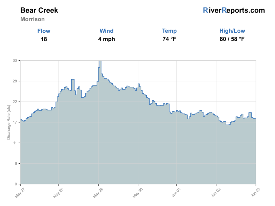
BlueStreamFly cannot read the latest value from this image. Check the chart on RiverReports Opens in a new tab.
If you go: Floating. A float is in play where this report supports boat access and wind, releases, and shuttle logistics are manageable.
Check first: Flow unavailable
Rating updatedRiver local time:
Float: A float is in play where this report supports boat access and wind, releases, and shuttle logistics are manageable.
NWS air forecast near
This is an air forecast, not a river-temperature reading. Check the water with a stream thermometer before fishing in hot weather.
RiverReports gauge
BlueStreamFly cannot read the latest value from this image. Check the chart on RiverReports Opens in a new tab.
Cloudy
The National Weather Service forecast is temporarily unavailable.
RiverReports gauge: Bear Creek near Morrison
Seasonal starting points, not a live hatch report. Match what you see on the water.
Each fly name opens its matching Fly Box guide.
Bear Creek is best when flows are cool and stable. If the creek is very low, warm, muddy, or crowded, treat it as a scouting day or choose a larger nearby river.
Use stealth, small dries, light droppers, and avoid walking through holding water.
Dry-dropper rigs and small nymphs can pick apart pocket water and plunge pools.
Wait for clarity or use a larger nearby river with safer visibility.
Fish early, carry a thermometer, and stop targeting trout if temperatures are stressful.
These scores compare the risks of wading, bank fishing, and floating.
Wading is in play only where your chosen access has clear footing, legal entry, and no forced crossings.
This report does not recommend bank fishing on this reach.
A float is in play where this report supports boat access and wind, releases, and shuttle logistics are manageable.
Is Bear Creek worth the trip today? Check flow, weather, hatches, access, and rules for Colorado before you go.
Bear Creek is a small foothills trout stream, so the right plan depends on exact reach, flow, temperature, and public access. This report is scoped to the Morrison and Bear Creek Lake Park area, not the closed El Paso County Bear Creek greenback reach.
Float: A float is in play where this report supports boat access and wind, releases, and shuttle logistics are manageable.
The USGS source did not return a usable value. Open the official station before committing to the trip.
Fall: Cooler water and lighter pressure make small dries, nymphs, and streamers more practical.
The current NWS air forecast is about 54F, and the next 24-hour high reaches about 73F. Cloudy.
No active NWS alert was returned for this forecast point.
Use the Morrison gauge trend as a small-water warning tool. Stable clear flows are the better fit for pocket water and soft edges, while storm spikes, mud, or very thin warm water should end the trout plan quickly.
Skip Bear Creek when thunderstorms stain the creek, when low warm water makes trout handling poor, when park or trail pressure is heavy, or when you cannot confirm the special fishing rule reach language for your exact section.
Choose one short public section and fish it carefully. Bear Creek works best when you slow down, cover shaded pockets and undercut edges, and leave room for other park users instead of hopping every visible pullout.
If Bear Creek is too warm, crowded, or off-color, pivot to Clear Creek for another close Front Range option or to Boulder Creek when a different small-stream plan fits the weather better.
Use these places as starting points. Open the access link below and check posted signs before you park or enter.
CPW lists Jefferson County Bear Creek special fishing rules from Evergreen Lake Dam to Bear Creek Reservoir. Verify current reach language, artificial-only rules, and rainbow/cutbow release rules before fishing.
Use the Morrison gauge and watch posted property around bridge and town access.
Lakewood manages recreation and fishing access in the park area. Check current park rules before entering.
Jefferson County park access is useful for walking the creek area where fishing is allowed and posted.
Official agencies and primary river operators come first. Secondary tools are labeled so you know what carries the most weight.
Check what is allowed, where the rule applies, and whether the river is open.
Check the latest river reading and forecast before you leave.
Check public entry points, land rules, and seasonal access changes.
Check what is allowed, where the rule applies, and whether the river is open.
Open the current rules and check the river section, season, and special limits.
Check the latest river reading and forecast before you leave.
Open this page and check the latest safety advice before your trip.
Open this river reading to check the latest level, flow, and update time.
Open this river reading to check the latest level, flow, and update time.
Check public entry points, land rules, and seasonal access changes.
Open the land or access page, then check signs before you park or enter.
Open the land or access page, then check signs before you park or enter.
What was checked: This report is maintained from current regulation, access, flow, weather, and public planning sources so anglers can make better trip decisions than a raw gauge or generic overview would allow.
Live measurements and forecasts keep their provider timestamps. Rules, access, and trip guidance use the source-review date shown here. BlueStreamFly planning advice is editorial interpretation, not an agency notice.
First-hand experience: BlueStreamFly does not claim a first-hand visit or local field test for this report unless a real contributor is explicitly named and linked.
It covers Jefferson County Bear Creek near Morrison and Bear Creek Lake Park, not the protected El Paso County Bear Creek.
It can be, but it is small and pressured, so beginners should focus on short casts, stealth, and low-impact handling.
Use RiverReports for the Bear Creek visual chart and USGS 06710605 Bear Creek above Bear Creek Lake near Morrison as the readable official backstop for the score. This is a better current-data match than the old Morrison station used before the July 6 review.
Use RiverReports for the Bear Creek visual chart and USGS 06710605 Bear Creek above Bear Creek Lake near Morrison as the readable official backstop for the score. This is a better current-data match than the old Morrison station used before the July 6 review.