RiverReports preview · current series loading
Recent flow
RiverReports gauge
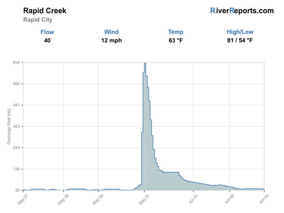
Showing the available RiverReports chart while the current structured flow series loads. Check the chart on RiverReports Opens in a new tab.
No single best way to fish. Wading and Bank fishing have the same top score. Use current access, footing, weather, and local rules to choose.
Rating updatedRiver local time:
USGS shows 18 cfs. The flow has been stable over about 6 hours. USGS marks this reading provisional and may revise it. USGS records for this date (2017-2026, 10 readings) show a median near 56 cfs and a low-water marker near 29 cfs; today's flow is unusually low for the date. Low water can make fish spooky, warm, pressured, or concentrated; check temperature and handling risk.
NWS air forecast near
This is an air forecast, not a river-temperature reading. Check the water with a stream thermometer before fishing in hot weather.
RiverReports gauge
Showing the available RiverReports chart while the current structured flow series loads. Check the chart on RiverReports Opens in a new tab.
Areas Of Fog
The National Weather Service forecast is temporarily unavailable.
RiverReports gauge: Rapid Creek at Rapid City
Seasonal starting points, not a live hatch report. Match what you see on the water.
Each fly name opens its matching Fly Box guide.
The best Rapid City creek days come on stable modest flow, cool mornings, and enough water clarity that you can spot shade lines and current cushions before stepping into them. Skip the middle of the day when foot traffic is heavy and the easiest park pockets have already been lined over.
Best for short nymph rigs, dry-dropper work, and careful streamer swings through park-side seams.
Fish early, stay off the skyline, and cover the near bank before stepping into any city-side run.
Treat it like a short soft-edge session and skip any stretch where the bankside visibility is gone.
Expect heavier public use and pick only the shadiest slots if water temperature still leaves a trout-safe margin.
Wading and Bank fishing have the same top score. Use current access, footing, weather, and local rules to choose.
Wading is in play only where your chosen access has clear footing, legal entry, and no forced crossings.
Bank and edge fishing remains a practical low-commitment option if access is legal and footing is safe.
This report does not recommend floating this reach.
Is Rapid Creek worth the trip today? Check flow, weather, hatches, access, and rules for Rapid City, South Dakota before you go.
Rapid Creek through Rapid City is one of the more unusual public trout options in the region because the city park system gives easy access while the creek still fishes like real tailwater-influenced trout water. Start with the RiverReports chart, keep USGS 06418800 open, and work a small set of greenway sections well instead of racing from bridge to bridge.
USGS shows 18 cfs. The flow has been stable over about 6 hours. USGS marks this reading provisional and may revise it. USGS records for this date (2017-2026, 10 readings) show a median near 56 cfs and a low-water marker near 29 cfs; today's flow is unusually low for the date. Low water can make fish spooky, warm, pressured, or concentrated; check temperature and handling risk.
Wade: Wading is in play only where your chosen access has clear footing, legal entry, and no forced crossings.
Fall: A top window for cooler water, lighter crowds, and better brown-trout intent.
The current NWS air forecast is about 49F, and the next 24-hour high reaches about 60F. Areas Of Fog.
No active NWS alert was returned for this forecast point.
Use the Rapid City gauge with stormwater, clarity, and park pressure. Stable clear flow is the best in-town signal.
Skip when stormwater is pushing the creek, water is warm, bridge current is unsafe, parks are crowded, or public-space use makes fishing awkward.
Start with the Rapid City gauge, then choose Canyon Lake, Founders, Memorial, or another municipal park before picking flies.
Compare Rapid Creek Below Pactola, upper Rapid Creek, or Castle Creek Below Deerfield when the city reach is high, warm, crowded, or storm-stained.
Use these places as starting points. Open the access link below and check posted signs before you park or enter.
Recheck the 2026 South Dakota Fishing Handbook and current state rules before fishing. Black Hills trout rules and any local restrictions still matter on the Rapid City reach.
A strong upstream city starting point where park access and the creek area line up cleanly.
Useful for working the creek-side path and greenway water without guessing at public access.
A good central-city checkpoint when you need easy parking and a short after-work session.
Official agencies and primary river operators come first. Secondary tools are labeled so you know what carries the most weight.
Check what is allowed, where the rule applies, and whether the river is open.
Check the latest river reading and forecast before you leave.
Check public entry points, land rules, and seasonal access changes.
Use these links for stocking, safety, and other local details.
Check what is allowed, where the rule applies, and whether the river is open.
Open the current rules and check the river section, season, and special limits.
Check the latest river reading and forecast before you leave.
Open this page and check the latest safety advice before your trip.
Open this river reading to check the latest level, flow, and update time.
Open this river reading to check the latest level, flow, and update time.
Check public entry points, land rules, and seasonal access changes.
Open the land or access page, then check signs before you park or enter.
Open the land or access page, then check signs before you park or enter.
Use these links for stocking, safety, and other local details.
Open this page for more river information and check when it was last updated.
Open this page for more river information and check when it was last updated.
What was checked: This report starts with official regulation, access, flow, weather, and public-land sources, then adds practical planning guidance for fly anglers.
Live measurements and forecasts keep their provider timestamps. Rules, access, and trip guidance use the source-review date shown here. BlueStreamFly planning advice is editorial interpretation, not an agency notice.
First-hand experience: BlueStreamFly does not claim a first-hand visit or local field test for this report unless a real contributor is explicitly named and linked.
Use RiverReports for the live chart and keep USGS site 06418800 at Rapid City open as the official in-town reference.
Start with the named public parks along the creek area such as Canyon Lake Park, Founders Park, and Memorial Park instead of guessing at informal pull-offs.
No. This route is the in-town Rapid City area and fishes differently from both the upper Silver City reach and the below-Pactola tailwater.


