RiverReports preview · current series loading
Recent flow
RiverReports gauge
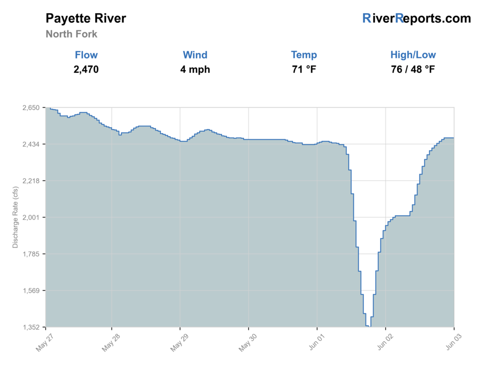
Showing the available RiverReports chart while the current structured flow series loads. Check the chart on RiverReports Opens in a new tab.
No access method is recommended today. Review the live conditions below before choosing another river or day.
Rating updatedRiver local time:
An active alert is in effect: Flash Flood Watch issued October 22 at 2:42PM MDT until October 23 at 12:00PM MDT by NWS Boise ID. Check public safety sources before going.
Flash Flood Watch issued October 22 at 2:42PM MDT until October 23 at 12:00PM MDT by NWS Boise ID
NWS air forecast near
This is an air forecast, not a river-temperature reading. Check the water with a stream thermometer before fishing in hot weather.
RiverReports gauge
Showing the available RiverReports chart while the current structured flow series loads. Check the chart on RiverReports Opens in a new tab.
Rain Showers
The National Weather Service forecast is temporarily unavailable.
RiverReports gauge: North Fork Payette River near Banks
Seasonal starting points, not a live hatch report. Match what you see on the water.
Also try hopper-dropper
Each fly name opens its matching Fly Box guide.
This river is most useful when flows settle enough to reveal fishable bank structure and when you want a canyon roadside day more than a technical trout destination. It is least useful when runoff, raft traffic, or unrealistic trout expectations override the actual character of the river.
Best for finding bank seams, eddies, and short nymph or dry-dropper drifts off official access points.
Good for more visible holding water, but also exposes just how limited safe bank entries can be.
Skip serious wading plans. The river becomes a whitewater area first and a fishing stop second.
Slow down with nymphs and work protected soft structure near accessible banks.
No access method is recommended in today's conditions. Review the live river and weather checks before making another plan.
Not recommended today. Recheck the river, weather, and access before planning another trip.
Not recommended today. Recheck the river, weather, and access before planning another trip.
Not recommended today. Recheck the river, weather, and access before planning another trip.
Is Payette River worth the trip today? Check flow, weather, hatches, access, and rules for North Fork, Idaho before you go.
The North Fork Payette is better known for rafting than trout glamour, but it can still make a solid fly-fishing day when flows are moderate enough to show real seams and when you choose access points that let you fish safely from the bank. This is a river for disciplined spot selection, not for pretending every roadside rapid is fishable.
An active alert is in effect: Flash Flood Watch issued October 22 at 2:42PM MDT until October 23 at 12:00PM MDT by NWS Boise ID. Check public safety sources before going.
This month is not listed as a top seasonal window in this page's reviewed season notes. Use current regulations, flow, temperature, and access checks before treating the score as a slam dunk.
The forecast has storm or heavy-precipitation risk, so timing and access matter more than the score alone.
USGS shows 275 cfs. The flow has been stable over about 6 hours. USGS marks this reading provisional and may revise it. USGS records for this date (1948-2026, 79 readings) show a typical middle range of 250 cfs to 475 cfs. Flow is within the typical range for this date, so weather, temperature, and access become the next checks.
The current NWS air forecast is about 50F, and the next 24-hour high reaches about 53F. Rain Showers.
Moderate flows that still show clear eddies, side current, and bank seams without turning every accessible stop into a safety problem.
Skip when runoff or canyon push leaves no clean edges, or when rafting traffic and highway crowds wipe out the quiet controlled stops this river needs.
Start near Banks, fish one named Forest Service access well, and move only when the next stop clearly offers softer structure or less shared-use traffic.
If the North Fork Payette is too forceful, switch to Mores Creek for small water or Boise River for a bigger but more forgiving urban-area option.
Use these places as starting points. Open the access link below and check posted signs before you park or enter.
IDFG's 2025-2027 North Fork Payette rules include catch-and-release trout rules from Smylie Bridge to Payette Lake between December 1 and the Friday of Memorial Day weekend, kokanee catch-and-release upstream of Payette Lake, and Southwest Region general rules on other sections. Check the current planner before choosing your exact reach.
A strong day-start anchor close to Banks with direct river adjacency and a named public site.
A practical mid-area stop where official access and fishable bank water line up well.
A useful farther-up canyon option where the Forest Service specifically notes trout and whitefish opportunity.
Official agencies and primary river operators come first. Secondary tools are labeled so you know what carries the most weight.
Check what is allowed, where the rule applies, and whether the river is open.
Check the latest river reading and forecast before you leave.
Check public entry points, land rules, and seasonal access changes.
Check what is allowed, where the rule applies, and whether the river is open.
Open the current rules and check the river section, season, and special limits.
Check the latest river reading and forecast before you leave.
Open this page and check the latest safety advice before your trip.
Open this river reading to check the latest level, flow, and update time.
Open this river reading to check the latest level, flow, and update time.
Check public entry points, land rules, and seasonal access changes.
Open the land or access page, then check signs before you park or enter.
Open the land or access page, then check signs before you park or enter.
Open the land or access page, then check signs before you park or enter.
What was checked: This report uses official regulation, flow, weather, and public-access sources first, then adds practical planning guidance for fly anglers.
Live measurements and forecasts keep their provider timestamps. Rules, access, and trip guidance use the source-review date shown here. BlueStreamFly planning advice is editorial interpretation, not an agency notice.
First-hand experience: BlueStreamFly does not claim a first-hand visit or local field test for this report unless a real contributor is explicitly named and linked.
It is primarily famous for whitewater, but it still offers worthwhile fly-fishing windows when flows are moderate and you fish safe accessible edges.
Usually no. The best plan is conservative bank-based fishing from official access points rather than ambitious canyon wading.
Start with RiverReports and USGS 13246000 near Banks for the lower canyon reach this page is built around.