RiverReports chart
Recent flow
RiverReports gauge
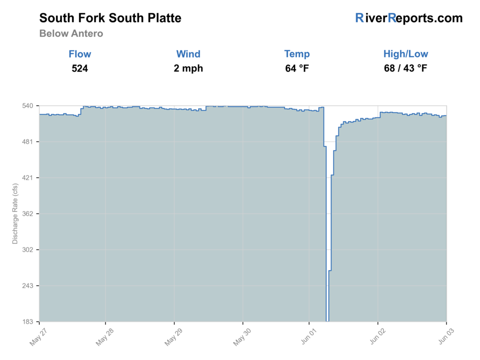
BlueStreamFly cannot read the latest value from this image. Check the chart on RiverReports Opens in a new tab.
Best option: Floating. A float is in play where this report supports boat access and wind, releases, and shuttle logistics are manageable.
Check first: No structured live flow
Rating updatedRiver local time:
RiverReports is linked for the flow chart, but this page does not have a structured live flow value the score can read automatically. Treat the rating as conservative and open the chart before committing.
NWS air forecast near
This is an air forecast, not a river-temperature reading. Check the water with a stream thermometer before fishing in hot weather.
RiverReports gauge
BlueStreamFly cannot read the latest value from this image. Check the chart on RiverReports Opens in a new tab.
Partly Sunny
The National Weather Service forecast is temporarily unavailable.
RiverReports gauge: South Fork South Platte below Antero
Seasonal starting points, not a live hatch report. Match what you see on the water.
Also try Black beauty
Each fly name opens its matching Fly Box guide.
This is usually a shoulder-season through fall wading plan for anglers who want technical meadow-river trout water without the broader crowds of Deckers. Wind, spring runoff, and ambiguous property lines all reduce the value of forcing a full-day commitment.
Best for reading cutbanks, soft seams, and short drifts without forcing long crossings.
Fish small flies, longer leaders, and a very low profile because the meadow setting exposes every mistake.
Treat the reach as a scouting stop or skip it rather than gambling on soft edges that are no longer really fishable.
Shorten leaders, simplify rigs, and expect the open valley to erase much of the delicate presentation advantage this reach usually rewards.
These scores compare the risks of wading, bank fishing, and floating.
Wading is in play only where your chosen access has clear footing, legal entry, and no forced crossings.
This report does not recommend bank fishing on this reach.
A float is in play where this report supports boat access and wind, releases, and shuttle logistics are manageable.
Is South Fork South Platte Below Antero worth the trip today? Check flow, weather, hatches, access, and rules for Colorado before you go.
The South Fork below Antero is most useful when flows are stable enough to leave distinct seams, the wind is manageable, and you respect how limited the legal access footprint can be. The better days come from working posted easement water carefully instead of wandering the valley and guessing where public fishing begins.
RiverReports is linked for the flow chart, but this page does not have a structured live flow value the score can read automatically. Treat the rating as conservative and open the chart before committing.
Float: A float is in play where this report supports boat access and wind, releases, and shuttle logistics are manageable.
Fall: Often the cleanest combination of stable water, cooler weather, and technical trout conditions.
The current NWS air forecast is about 41F, and the next 24-hour high reaches about 63F. Partly Sunny.
No active NWS alert was returned for this forecast point.
Stable moderate flows that keep cutbanks, riffle edges, and meadow seams distinct without erasing the softer holding water.
Skip when South Park wind overwhelms presentation, when runoff or release changes bury the banks, or when you cannot confirm the easement you plan to use.
Start with one CPW access point, fish the best bank structure close to the legal area, and keep a canyon backup ready if wind or water shape turns against you.
If this reach gets too windy or vague on access, pivot to Eleven Mile Canyon or the broader Deckers South Platte area.
Use these places as starting points. Open the access link below and check posted signs before you park or enter.
Colorado special fishing rules on the South Fork South Platte in Park County are protective and section-by-section. Artificial flies and lures only apply on the below-Antero and lower South Fork sections, and trout return and size-limit rules change by subsection. Check the current Colorado special fishing rules page before fishing.
The main below-Antero public fishing anchor with fenced and posted easement access and designated parking only.
A narrower public easement where access is limited to within 25 feet of the stream centerline.
Useful for supplies and weather decisions before you commit to the open South Park valley.
Official agencies and primary river operators come first. Secondary tools are labeled so you know what carries the most weight.
Check what is allowed, where the rule applies, and whether the river is open.
Check the latest river reading and forecast before you leave.
Check public entry points, land rules, and seasonal access changes.
Check what is allowed, where the rule applies, and whether the river is open.
Open the current rules and check the river section, season, and special limits.
Check the latest river reading and forecast before you leave.
Open this page and check the latest safety advice before your trip.
Open this river reading to check the latest level, flow, and update time.
Check public entry points, land rules, and seasonal access changes.
Open the land or access page, then check signs before you park or enter.
Open the land or access page, then check signs before you park or enter.
Open the land or access page, then check signs before you park or enter.
What was checked: This report uses official regulation, flow, weather, access, and public-land sources first, then adds practical planning guidance for fly anglers.
Live measurements and forecasts keep their provider timestamps. Rules, access, and trip guidance use the source-review date shown here. BlueStreamFly planning advice is editorial interpretation, not an agency notice.
First-hand experience: BlueStreamFly does not claim a first-hand visit or local field test for this report unless a real contributor is explicitly named and linked.
No. This page is for the South Fork South Platte below Antero in South Park, not the Deckers and Cheesman area farther downstream.
Start with the CPW Badger Basin and Knight-Imler pages because they describe the public easements and parking limits that matter most here.
Skip when strong wind ruins line control, when flows remove the softer meadow seams, or when you are unsure about the easement boundaries you plan to fish.


