RiverReports preview · current series loading
Recent flow
RiverReports gauge
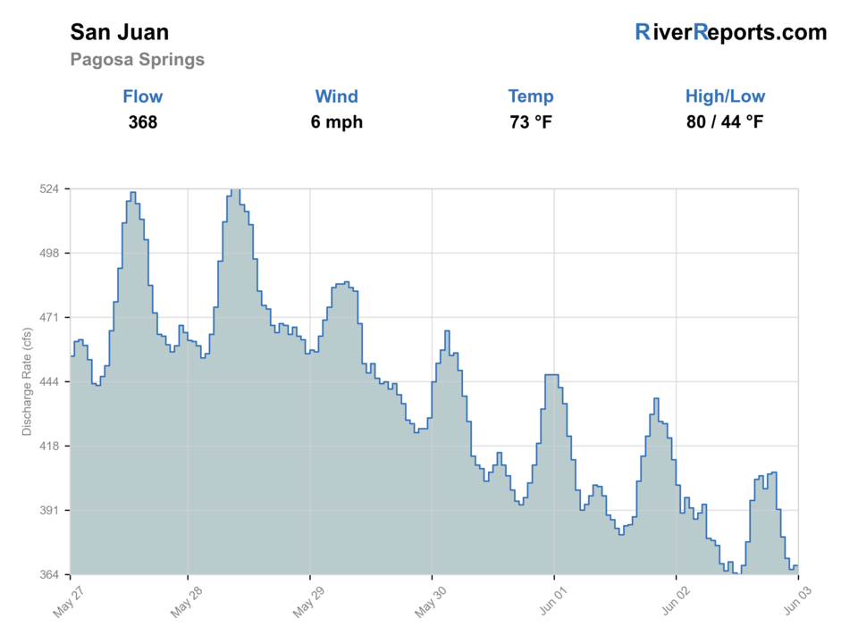
Showing the available RiverReports chart while the current structured flow series loads. Check the chart on RiverReports Opens in a new tab.
Flow is high for this time of year.
No access method is recommended today. Review the live conditions below before choosing another river or day.
Rating updatedRiver local time:
USGS shows 269 cfs. The flow has been rising about 16% over about 6 hours. USGS marks this reading provisional and may revise it. USGS records for this date (1936-2025, 90 readings) show a median near 89 cfs and the upper quartile near 207 cfs; today's flow is high for the date. Fishable water may exist, but do not rate it highly without a safe access, clarity, and wading or boat plan.
NWS air forecast near
This is an air forecast, not a river-temperature reading. Check the water with a stream thermometer before fishing in hot weather.
RiverReports gauge
Showing the available RiverReports chart while the current structured flow series loads. Check the chart on RiverReports Opens in a new tab.
Showers And Thunderstorms
The National Weather Service forecast is temporarily unavailable.
RiverReports gauge: San Juan River at Pagosa Springs
Seasonal starting points, not a live hatch report. Match what you see on the water.
Each fly name opens its matching Fly Box guide.
Summer mornings and early fall are the best practical windows. Spring runoff and high tubing flows can make fishing less useful even when access is easy.
Use small dries, light nymphs, and careful approaches around visible fish.
Best blend for short nymph rigs, dry-droppers, and edge fishing.
Fishing may be less practical around tubing and fast water.
Fish early and quit if trout handling becomes stressful.
No access method is recommended in today's conditions. Review the live river and weather checks before making another plan.
Not recommended today. Recheck the river, weather, and access before planning another trip.
Not recommended today. Recheck the river, weather, and access before planning another trip.
Not recommended today. Recheck the river, weather, and access before planning another trip.
Is San Juan at Pagosa Springs worth the trip today? Check flow, weather, hatches, access, and rules for Colorado before you go.
The San Juan through Pagosa Springs is convenient, scenic, and flow-sensitive. It is most useful when the river is clear enough to fish, public access is obvious, and town recreation does not crowd the best holding water.
USGS shows 269 cfs. The flow has been rising about 16% over about 6 hours. USGS marks this reading provisional and may revise it. USGS records for this date (1936-2025, 90 readings) show a median near 89 cfs and the upper quartile near 207 cfs; today's flow is high for the date. Fishable water may exist, but do not rate it highly without a safe access, clarity, and wading or boat plan.
The forecast has storm or heavy-precipitation risk, so timing and access matter more than the score alone.
An active public alert is in effect near this forecast point, so the score is capped at caution until conditions are checked. NWS alert: Hydrologic Outlook issued October 9 at 10:53AM MDT by NWS Grand Junction CO.
Fall: Often the best mix of clear flows, cooler water, and lower recreation pressure.
The current NWS air forecast is about 52F, and the next 24-hour high reaches about 60F. Showers And Thunderstorms.
Clear, moderate flows that leave fishable edges without heavy tubing pressure.
Skip during high runoff, heavy town recreation, dirty water, or warm low-water afternoons.
Check the gauge and public access in town, fish early, then move to the Piedra or Animas if the town reach is crowded.
Piedra River is the best nearby change-of-pace when town access or recreation pressure limits the San Juan.
Use these places as starting points. Open the access link below and check posted signs before you park or enter.
Check the current Colorado fishing brochure before fishing the Pagosa Springs reach. Use New Mexico rules only if you travel downstream to New Mexico water.
Use designated town access points for the San Juan River area.
A practical flow reference for town-water timing.
Useful for scouting public river use and crowding before fishing.
Official agencies and primary river operators come first. Secondary tools are labeled so you know what carries the most weight.
Check what is allowed, where the rule applies, and whether the river is open.
Check the latest river reading and forecast before you leave.
Check public entry points, land rules, and seasonal access changes.
Check what is allowed, where the rule applies, and whether the river is open.
Open the current rules and check the river section, season, and special limits.
Open the current rules and check the river section, season, and special limits.
Check the latest river reading and forecast before you leave.
Open this page and check the latest safety advice before your trip.
Open this river reading to check the latest level, flow, and update time.
Open this river reading to check the latest level, flow, and update time.
Check public entry points, land rules, and seasonal access changes.
Open the land or access page, then check signs before you park or enter.
What was checked: This report uses official regulation, flow, weather, access, and public-land sources first, then adds practical planning guidance for fly anglers.
Live measurements and forecasts keep their provider timestamps. Rules, access, and trip guidance use the source-review date shown here. BlueStreamFly planning advice is editorial interpretation, not an agency notice.
First-hand experience: BlueStreamFly does not claim a first-hand visit or local field test for this report unless a real contributor is explicitly named and linked.
No. This page covers the San Juan River at Pagosa Springs, Colorado. The Navajo Dam tailwater is in New Mexico.
Use designated public river access locations and respect posted banks, other river users, and private property.
Fish early when water is cooler and town recreation pressure is lighter.


